Tropical Storm Erin formed in the Atlantic Monday morning, Aug. 11.
The National Hurricane Center issued its first advisory on the fifth-named storm of the Atlantic hurricane season at 11 a.m., warning Erin could become a hurricane by Wednesday, Aug. 13 and a major hurricane by Saturday, Aug. 16, as it moves quickly west across the Atlantic.
➤ Weather alerts via text: Sign up to get updates about current storms and weather events by location
AccuWeather forecasters are predicting Erin could turn north on a parallel path to Florida as it approaches the Caribbean.
The National Hurricane Center is also tracking a new disturbance in the Gulf, which has a low chance for development but could bring heavy rainfall to the Florida Panhandle over the next day or two.
Elsewhere in the Atlantic basin, at its 2 p.m. advisory, the National Hurricane Center was tracking two other systems.
Invest 96L is moving north in the central Atlantic and has a low chance for development.
Another disturbance is a non-tropical area of low pressure a few hundred miles south-southeast of Nova Scotia. It also has a low chance for development.
Will Sarasota, Bradenton and Manatee County see impacts from Erin?
Here's the latest advisory from the National Hurricane Center as of 2 p.m., Aug. 11:
Tropical Storm Erin develops in eastern Atlantic. Expected to become major hurricane
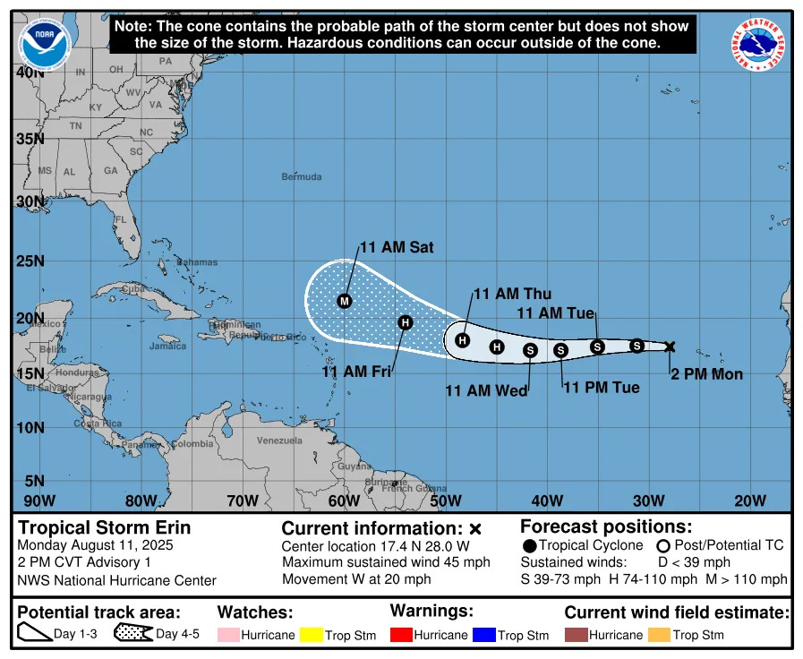
Invest 97L became Tropical Storm Erin Monday morning, with the National Hurricane Center issuing its first advisory on the system at 11 a.m. Aug. 11.
Forecasters are predicting Erin will continue to strengthen as it moves quickly across the Atlantic, becoming a hurricane on Wednesday, Aug. 13, and a major hurricane with 115-mph winds by Saturday, Aug. 16.
NOAA hurricane tracker: See spaghetti models for Tropical Storm Erin
Special note about spaghetti models: Illustrations include an array of forecast tools and models, and not all are created equal. The hurricane center uses only the top four or five highest performing models to help make its forecasts.
National Hurricane Center tracking 4 systems. How likely are they to strengthen?
Northeastern Gulf: A weak surface trough in the northeastern Gulf near the Florida Panhandle is associated with a broad area of disorganized showers and thunderstorms. While development of this system is not anticipated before it moves inland, locally heavy rainfall could produce flash-flooding along portions of the Florida Panhandle over the next day or so.
Formation chance through 48 hours: low, near 0 percent.
Formation chance through 7 days: low, near 0 percent.
Invest 96L: A weak surface trough of low pressure located over the central Atlantic is interacting with an upper-level trough, producing scattered disorganized shower and thunderstorm activity. Significant development of this system appears unlikely over the next few days as the system drifts generally northward, remaining over the central Atlantic.
Formation chance through 48 hours: low, 10 percent.
Formation chance through seven days: low, 10 percent.
Area of low pressure: A non-tropical area of low pressure is currently located a few hundred miles to the south-southeast of Nova Scotia, Canada. While current shower and thunderstorm activity with the system remains limited, this system is drifting over the warm waters of the Gulf Stream, and some tropical or subtropical development could occur over the next day or two. By the middle of this week, the system isexpected to move northward over cooler waters, ending its chances for further tropical development.
Formation chance through 48 hours: low, 10 percent.
Formation chance through seven days: low, 10 percent.
What is an invest?
Short for investigation, the National Hurricane Center uses the term invest for areas of low pressure it is monitoring for potential development into a tropical depression or storm.
Invests are not tropical depressions or tropical storms. They're usually clusters of showers and thunderstorms, and just because they've been designated as an invest does not guarantee they'll strengthen into a tropical storm or hurricane.
Invests run from 90 to 99, followed by a letter: L for the Atlantic basin and E for those in the eastern Pacific. After 99, it starts over again and the next invest would be 90.
Once something has been designated as an invest, specialized data sets and computer models can begin, including scheduling Hurricane Hunter aircraft missions and running spaghetti models.
What do the colored, hatched areas on the NOAA map mean?
The hatched areas on the National Hurricane Center's tropical outlook map indicate "areas where a tropical cyclone — which could be a tropical depression, tropical storm or hurricane — could develop," said National Hurricane Center Deputy Director Jamie Rhome.
The colors make it visibly clear how likely a system could develop, with yellow being low, orange medium, and red high.
The National Hurricane Center generally doesn't issue tropical advisories until there is a named storm, but there is an exception.
"If a system is near land and there is potential for development, the National Hurricane Center won't wait before it issues advisories, even if the system hasn't become an actual storm. This gives residents time to prepare," Rhome said.
Are Sarasota, Bradenton, Manatee County likely to be impacted by Tropical Storm Erin?
It's too early at this time to determine if there will be any impact to Florida or the U.S. from Tropical Storm Erin.
Erin could bring an increase in rough surf and rip currents to the east coast next weekend and into early next week, even if it curves north, staying away from Florida and the U.S., according to AccuWeather.
"The tropics remain quiet, and are likely to stay that way for another 10 days or more," said Ryan Truchelut on Aug. 9.
"While there is hope the active peak months of hurricane season may not translate into another awful year in human terms, the reality is that U.S. hurricane impacts are likely and to be expected over the next few months."
Truchelut is the chief meteorologist with WeatherTiger and works with the USA TODAY Network.
Sarasota, Bradenton, Manatee County weather radar for Aug. 11, 2025. See rain associated with system in Gulf
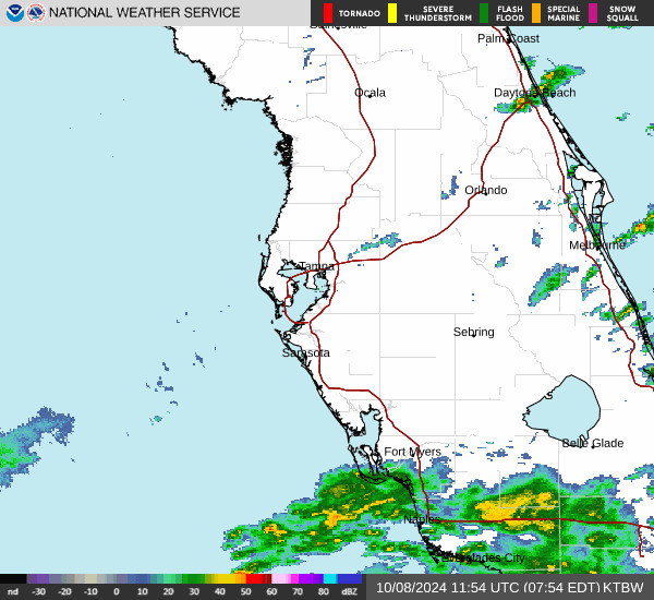
A disturbance in the northeast Gulf has a near 0 percent chance of developing before it moves onshore, the National Hurricane Center said "locally heavy rainfall could produce flash-flooding along portions of the Florida Panhandle overthe next day or so."
Weather watches and warnings issued in Sarasota, Bradenton, Manatee County
When is the Atlantic hurricane season?
The Atlantic hurricane season runs from June 1 through Nov. 30.
Ninety-seven percent of tropical cyclone activity occurs during this time period, NOAA said.
The Atlantic basin includes the northern Atlantic Ocean, Caribbean Sea and Gulf of America, as the Gulf of Mexico is now known in the U.S. per an order from President Trump. NOAA and the National Hurricane Center are now using Gulf of America on its maps and in its advisories.
When is the peak of hurricane season?
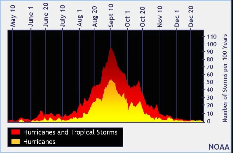
The peak of the season is Sept. 10, with the most activity happening between mid-August and mid-October, according to the Hurricane Center.
Hurricane names for 2025 season
Here are the names for the 2025 Atlantic hurricane season, along with how to pronounce them. The first hurricane of the season typically forms Aug. 11.
Andrea(June 20)Barry(June 29)Chantal(July 5)Dexter: (Aug. 3)Erin: AIR-rin (Aug. 11)
Fernand: fair-NAHN (historically forms Aug. 29)
Gabrielle: ga-bree-ELL
Humberto: oom-BAIR-toh
Imelda: ee-MEHL-dah
Jerry: JEHR-ee
Karen: KAIR-ren
Lorenzo: loh-REN-zoh
Melissa: meh-LIH-suh
Nestor: NES-tor
Olga: OAL-guh
Pablo: PAHB-lo
Rebekah: reh-BEH-kuh
Sebastien: se-BAS-tee-en
Tanya: TAHN-yuh
Van: van
Wendy: WEN-dee
National Hurricane Center map: See what forecasters watching now
Systems currently being monitored by the National Hurricane Center include:
Why does NHC say 'tropical cyclone' on its maps instead of hurricane or tropical storm?
Tropical cyclone is the generic term used by the National Weather Service, NOAA and the National Hurricane Center for any tropical system, even if it's in the tropical Atlantic basin.
To be more precise, a tropical cyclone is a "rotating, organized system of clouds and thunderstorms that originates over tropical or subtropical waters and has closed, low-level circulation," NOAA sadi.
Once maximum sustained winds reach 74 mph, what it is called is determined by where it originated:
Hurricane: for storms in the North Atlantic, central North Pacific, and eastern North Pacific.
Typhoon: for storms in the Northwest Pacific.
Cyclone: for storms in the South Pacific and Indian Ocean.
Interactive map: Hurricanes, tropical storms that have passed near your city
Stay informed. Get weather alerts via text
What's next?
We will update our tropical weather coverage daily.
Download your local site's app to ensure you're always connected to the news. And look for our special subscription offers here.
This article originally appeared on Sarasota Herald-Tribune: Tropical Storm Erin 2025 spaghetti models. Sarasota, Bradenton impact


Comments