Central Louisiana, the region that encompasses the state's midsection, is made up of the Avoyelles, Catahoula, Concordia, Grant, LaSalle, Rapides, Vernon and Winn parishes.
Central Louisiana's landscape is made up of extensive prairies, piney hills, as well as minor swamplands, rivers and deciduous forests.
Louisiana's geographical center point lies within this region, nestled in a rural setting within a small town.
Louisiana's geographical center point located in Avoyelles Parish. Here's what to know
The answer of where Louisiana's geographical center is lies in Avoyelles Parish, where the Avoyelles Commission of Tourism has commemorated the "Centre de la Louisiane," designating the point with a marker in October 2024.
The geographic center of Louisiana can be found in Avoyelles Parish, southeast of Marksville, within the town of Mansura. The marker indicating the "Centre de la Louisiane" is located on Old River Road, about five miles southeast of Marksville, near the Raccourci Old River.
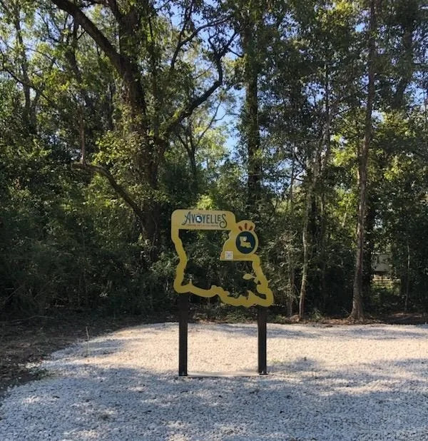
While the marker can be difficult to find, as it's considered to be off the beaten path, the Avoyelles Commission of Tourism has placed kiosks with QR codes throughout the parish. When the QR code is scanned, a site will pop up that provides information on how to find Louisiana's marked center point.
Visitors will know they've found the center when they see a sign designating the center, a sign that also happens to double as a great photo op, according to Travel Avoyelles.
Presley Bo Tyler is a reporter for the Louisiana Deep South Connect Team for Gannett/USA Today. Find her on X @PresleyTyler02 and email at [email protected]
This article originally appeared on Shreveport Times: Where is the center of Louisiana? Geographical center point found here


Comments