Hurricane Erin formed in the Atlantic Aug. 15 and rapidly strengthened to a catastrophic Category 5 storm with 160 mph winds on Saturday, Aug. 16, according to the latest advisory from the National Hurricane Center.
Erin is the first hurricane of the 2025 Atlantic hurricane season.
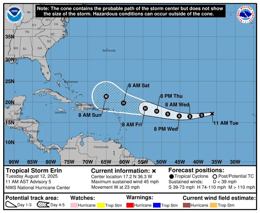
Hurricane Erin's center position was estimated at about 235 mile east-northeast of San Juan, Puerto Rico and roughly 1,800 miles east-southeast of Miami.
The outer bands of Erin are expected to produce 2 to 4 inches of rainfall and isolated totals of 6 inches across the northern Leeward Islands, the Virgin Islands, and Puerto Rico through Aug. 17. Flash and urban flooding, and landslides or mudslides, are possible.
Erin continues to move fairly quickly to the west-northwest, but a turn to the north is expected early next week.
➤ Weather alerts via text: Sign up to get updates about current storms and weather events by location
Tropical storm watches are in effect for St. Martin, St. Barthelemy and Sint Maarten with tropical storm conditions possible within the next 12 hours.
Interests elsewhere in the northern Leeward Islands, Virgin Islands, and Puerto Rico, as well as in the Turks and Caicos and the southeastern Bahamas should monitor the progress of Erin, the hurricane center advised.
The center of Erin is expected to move just north of the northern Leeward Islands, the Virgin Islands, and Puerto Rico over the weekend.
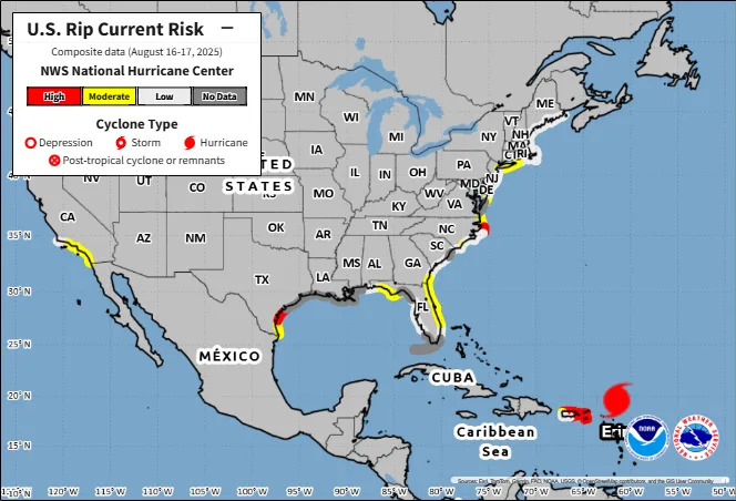
Erin is expected to produce dangerous surf and rip currents along the beaches of the Bahamas, much of the east coast of the U.S., including Florida, and Atlantic Canada next week.
Erin is expected to bring dangerous conditions to offshore waters and beaches along the Florida coast from Aug. 18 - 21, including rip currents and rough, high surf with breakers greater than 7 feet on the 19th and 20th, said the weather service office in Jacksonville, Florida.
➤ Hurricane drama vs. data: Why Erin is a minuscule threat to Florida, U.S. east coast
Hurricane categories: Saffir-Simpson Hurricane Wind Scale
Category 1 hurricane: 74-95 mph
Category 2 hurricane: 96-110 mph
Category 3 hurricane: 111-129 mph
Category 4 hurricane: 130-156 mph
Category 5 hurricane: 157 mph or higher
Hurricane Erin update, path
Special note on the NHC cone: The forecast track shows the most likely path of the center of the storm. It does not illustrate the full width of the storm or its impacts, and the center of the storm is likely to travel outside the cone up to 33% of the time.
Location: 1050 miles north of Anguilla
Maximum sustained winds: 160 mph
Movement: west-northwest at 17 mph
Pressure: 917 mb
Next advisory: 2 p.m. ET
Hurricane Erin now a Category 5 storm
Hurricane Erin strengthened to a catastrophic Category 5 storm with 160 mph winds Saturday, Aug. 16.
Spaghetti models for Hurricane Erin. Where is the storm going?
Special note about spaghetti models: Illustrations include an array of forecast tools and models, and not all are created equal. The hurricane center uses only the top four or five highest performing models to help make its forecasts.
Is there a hurricane coming to Florida?
No. Erin is moving west-northwest and the center of the storm is expected to remain east of Florida.
Remember, forecasts can change, so it's always best to be prepared.
What impacts could Hurricane Erin have on Florida?
"The threat of direct impacts in the Bahamas and along the east coast of the United States appears to be gradually decreasing.
"There will still be a significant risk of dangerous surf and rip currents along western Atlantic beaches next week."
How strong is Hurricane Erin and where could it go? See the scenarios
At 11:20 a.m., the center of Hurricane Erin was located near latitude 19.7 North, longitude 62.8 West.
Erin is moving toward the west near 17 mph, and this motion is expected to continue this afternoon.
A turn toward the west-northwest is expected tonight with a decrease in forward speed, and a turn toward the north is expected to occur early next week.
On the forecast track, the center of Erin is expected to move just north of the northern Leeward Islands, the Virgin Islands, and Puerto Rico over the weekend.
Reports from Air Force Reserve and NOAA Hurricane Hunter aircraft indicate that maximum sustained winds have increased to near 160 mph with higher gusts.
Erin is a Category 5 hurricane on the Saffir-Simpson Hurricane Wind Scale. Fluctuations in intensity are expected for the rest of the weekend.
Hurricane-force winds extend outward up to 30 miles (45 km) from the center and tropical-storm-force winds extend outward up to 140 miles mainly to the north of the center.
Have any watches or warnings been issued for Hurricane Erin?
A tropical storm watch is in effect for:
St. Martin and St. Barthelemy
Sint Maarten
A Tropical Storm Watch means that tropical storm conditions are possible within the watch area, in this case within the next 12 hours.
Hazards affecting land from Hurricane Erin
RAINFALL: The outer bands of Erin are expected to continue producing areas of heavy rainfall through Sunday across the northern Leeward Islands, the Virgin Islands, and Puerto Rico. Rainfall totals of 2 to 4 inches, with isolated totals of 6 inches, are expected. Locally considerable flash and urban flooding, along with landslides or mudslides, are possible.
WIND: Tropical storm conditions are possible within the watch area today.
SURF: Swells generated by Erin will affect portions of the northern Leeward Islands, the Virgin Islands, Puerto Rico, Hispaniola, and the Turks and Caicos Islands through the weekend. These swells will spread to the Bahamas, Bermuda, and the east coast of the United States early next week. These rough ocean conditions will likely cause life-threatening surf and rip currents. Please consult products from your local weather forecast office for more information.
Key messages from the National Hurricane Center: What you need to know about Hurricane Erin
Heavy rainfall at times through Sunday across the northern Leeward Islands, the Virgin Islands, and Puerto Rico may lead to locally considerable flash and urban flooding, along with landslides or mudslides.
Gusts to tropical storm force in Erin's outer rainbands are likely in portions of the northern Leeward Islands through tonight and over portions of the Virgin Islands and Puerto Rico later today through Sunday. Tropical-storm force wind gusts are possible in the Turks and Caicos Islands and Southeast Bahamas
Erin is expected to produce life-threatening surf and rip currents along the beaches of the Bahamas, much of the east coast of the U.S., and Atlantic Canada next week.
Interests in Bermuda should continue to monitor the progress of Erin since there is a risk of strong winds, heavy rainfall, and high surf by the middle part of next week.
Current forecast: How strong could Hurricane Erin get?
At 11 a.m.: 160 mph
12 hours: 165 mph
24 hours: 160 mph
36 hours: 155 mph
48 hours: 150 mph
60 hours: 145 mph
72 hours: 140 mph
96 hours: 130 mph
120 hours: 110 mph
System off North Carolina has low chance of development
Northwestern Atlantic: A broad and weak area of low pressure located off the coast of North Carolina is producing disorganized shower activity.
Some slight development of this system is possible over the next day or two while it moves little over the warm waters of the Gulf Stream.
By Monday, environmental conditions are expected to become unfavorable for further development.
Formation chance through 48 hours: low...10 percent.
Formation chance through 7 days: low...10 percent.
Interactive map: What tropical storms, hurricanes have impacted your area in the past?
Stay informed. Get weather alerts via text
What's next?
We will update our tropical weather coverage daily.
Download your local site's app to ensure you're always connected to the news. And look for our special subscription offers here.
Contributing: Dinah Pulver, USA TODAY
This article originally appeared on Palm Beach Post: Hurricane Erin path: Storm track, Florida impact


Comments