As dangerous heat sears the Kansas City area this weekend, it’s hard to imagine snow blanketing the metro.
Even as the dog days of August keep air conditioners working overtime, we at The Star can’t resist asking: What will the coming cold season hold?
With summer winding down and winter on the horizon, we took a look ahead.
To find out, we dug into three-month seasonal forecast outlooks from the National Weather Service’s Climate Prediction Center for the fall and winter months. We also spoke with a climatologist and the folks from the Farmers’ Almanac.
For many, this summer has felt like one of the most miserably hot in recent memory. But the reality isn’t quite as extreme as some may believe. High humidity, rather than record-breaking temperatures, is what has made this summer feel so oppressive.
And just because it’s been hot this summer doesn’t mean the metro is destined for an equally dramatic winter.
“Some people think that, ‘Wow, it’s so hot now our winter’s going to be very cold,’” said Doug Kluck, a retired National Oceanic and Atmospheric Administration climatologist. “That doesn’t hold water, scientifically.”
Mild, harsh, normal: No clear signal
From a climatological point of view, the winter months are December, January and February.
Kluck says it’s difficult to predict which months will feel colder, but he can offer some clues as to what we might expect.
From seasonal outlooks and recent weather trends to water temperatures out in the Pacific, there’s a lot that goes into predicting what Kansas City’s winter might bring. But even after weighing all the data, Kluck says there is a lot of uncertainty and forecasts will likely change between now and when winter sets in.
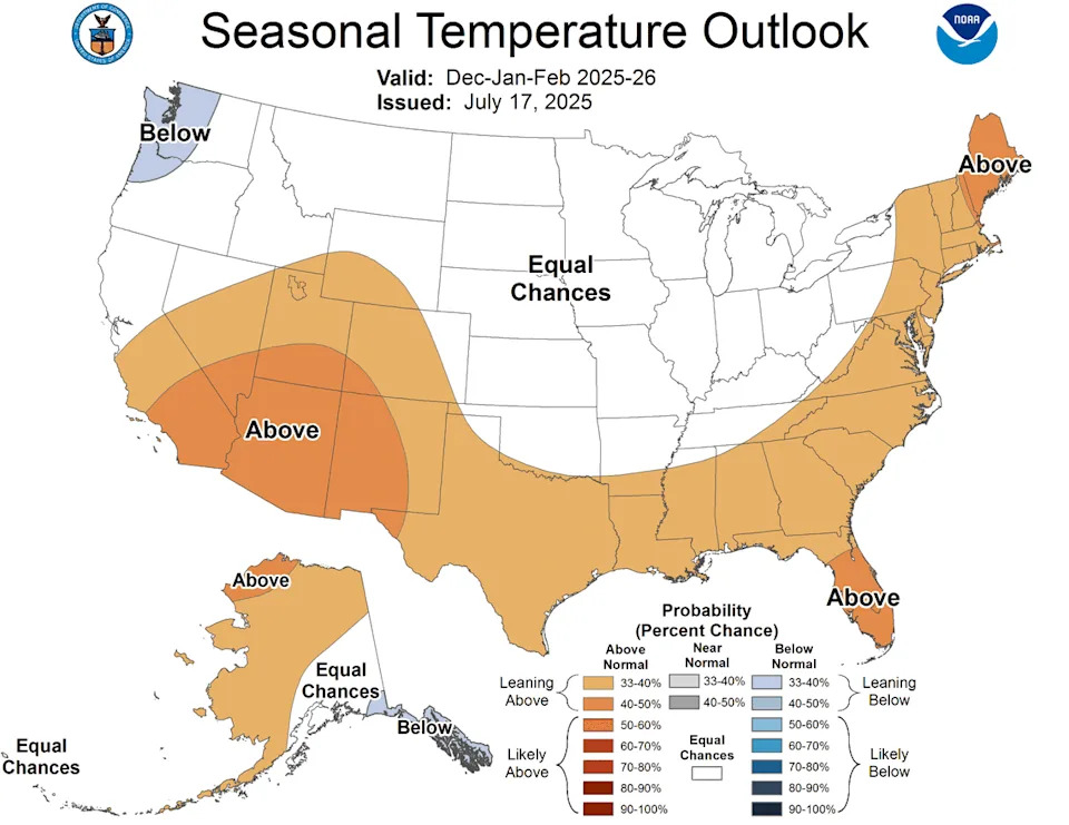
Looking at the Climate Prediction Center’s three-month outlook for winter, there’s no clear signal on what the weather will be like.
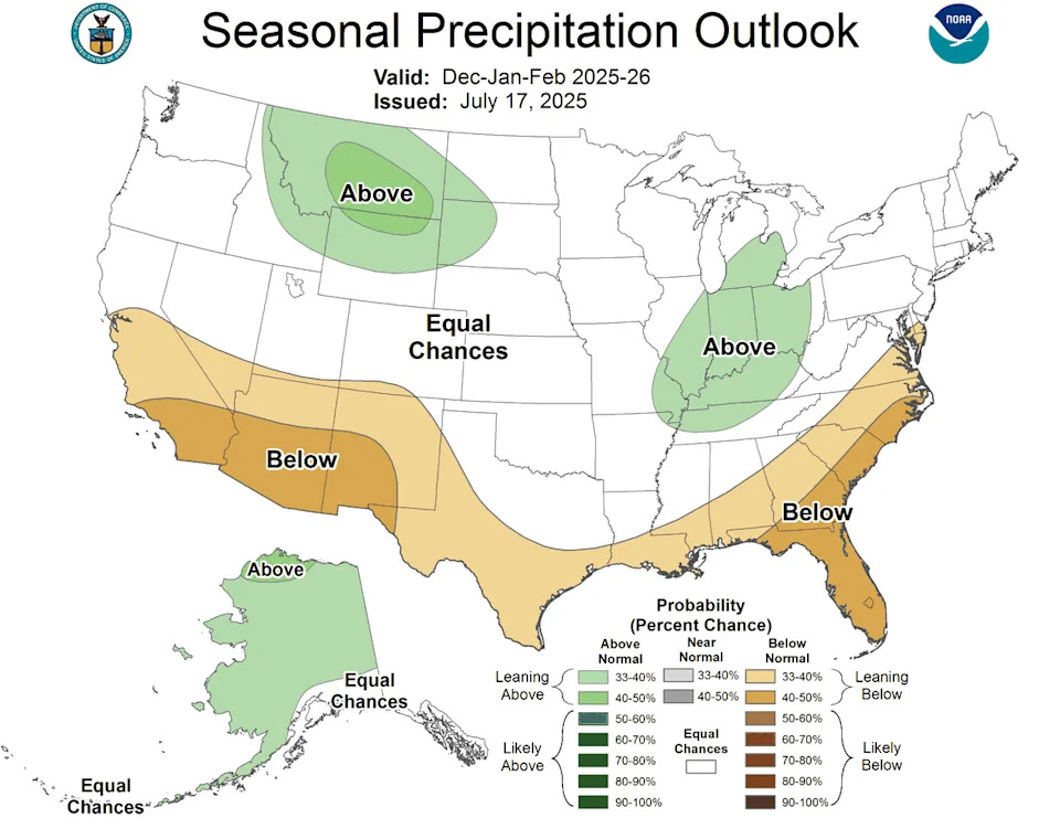
The latest outlook gives Kansas City about equal odds for winter being warmer, colder, or about average — both for temperatures and precipitation. In other words, it’s a toss-up.
For fall, which is September, October and November, the Climate Prediction Center says that temperatures are leaning toward being warmer than usual, with equal chances of precipitation.
The same holds for the period that leads into early winter — October, November and December.
Examining trends reveals that it has been warmer than usual, particularly in the fall, Kluck said.
“If you remember last October, we were in the 90s,” he said. “It was actually pretty brutal.”
NOAA’s official winter forecast still to come
But that doesn’t guarantee a repeat performance this year.
The tendency for warmer-than-normal conditions has also stretched into November and December, he said.
“There’s a flip point in there somewhere where all of a sudden we get cold,” Kluck said.
While a week or two of cold is still possible, odds slightly favor warmer-than-usual temperatures overall for early winter.
By the time the winter months of December, January and February roll around, the current forecast stands at equal chances for both temperatures and precipitation for Kansas City.
The outlooks aren’t official forecasts, and the agency updates them on the third Thursday of every month. NOAA won’t issue an official winter forecast until October.
“Stay tuned, because inevitably, the outlook will change between now and October when the official winter forecast comes up,” Kluck said.
Will a weak La Niña affect KC’s weather?
Another factor coming into play is the water temperature in the Pacific Ocean.
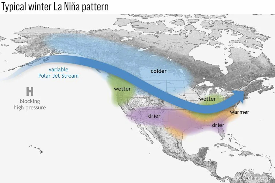
Forecasters expect La Niña conditions to develop this fall and early winter, according to an update from the Climate Prediction Center.
La Niña — a pattern of cooler-than-average Pacific Ocean waters — may develop this fall and linger into early winter, but forecasters say it will likely be weak and short-lived.
“Oftentimes these weak La Niñas can mean more snow — it doesn’t mean they will — but there’s a slight tendency towards more snow and a slight tendency towards colder than normal.”
That’s especially true for the upper Midwest and northern Plains.
But will that mean colder or snowier conditions closer to the Kansas City area? It’s complicated.
Kansas City sits in between the typically wetter, colder north and the milder, drier south in a typical La Niña pattern.
Kluck says he’s seen both very warm winters and brutally cold winters during La Niñas. But these years often come with wilder temperature swings, opening the door for more cold air outbreaks.
A study published last year on Climate.Gov showed that from the Nebraska and Iowa border north, snowfall tends to be heavier from Nebraska and Iowa north during a weak La Niña, Kluck said. Missouri and Kansas tend to have a little less snowfall.
What are others saying about the upcoming winter?
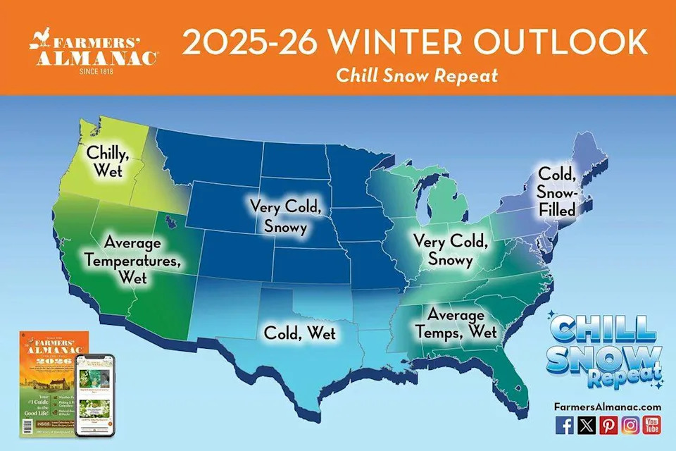
The Farmers’ Almanac released its extended weather forecast for the 2025-26 winter season earlier this week, saying that for the country as a whole it will be a “chill, snow and repeat” pattern, said Editor Sandi Duncan.
“It’s going to be kind of a wild ride with endless looping of this chill-snow-repeat,” Duncan said.
The Farmers’ Almanac uses a proprietary astronomical and mathematical formula that dates back to 1818, which looks at things like planet positions, the moon location, as well as sunspot activity for the basis of its long-range outlooks.
For the region that covers Kansas and Missouri, Duncan predicts “cold and snowy/wet conditions.”
Fall will start warm, but finish cold and rainy. Halloween should be okay, Duncan said, but there might be some precipitation during Thanksgiving.
Mid-November into December is when that cold, rainy finish to the fall season will occur, Duncan said, with some possible snow in mid-December for the more northern areas of Kansas City’s region.
“Make sure you have your sweaters and your firewood ready,” Duncan advised, adding that mid-January and mid-February stand out for bitter cold in the Almanac’s forecast.
They are also expecting moderate snowfall between January 16th and 19th, followed by rain in southern Missouri and Kansas towards the end of January.
“In February, we do see a possible snowstorm around the 19th of February in Kansas, and then a wintry mix for southern Missouri,” Duncan said. “So towards the end of February, I’d keep your eyes out on either snow, icy, wintry conditions for sure.”
Unfortunately, the winter weather is expected to persist, with the possibility of snow and cold temperatures lasting into the middle of March. The spring warm-up will hold off until the beginning of April.
“It will be a decent spring once it finally gets here,” Duncan said.
As anyone who’s weathered a few Kansas City winters knows, forecasts may give us hints, but around here, the weather always gets the last word. All we can do is wait and see what the season brings.


Comments