Aug. 17 (UPI) -- Hurricane Erin weakened to a Category 3 storm with maximum sustained winds of 125 mph as its outer bands pounded the Virgin Islands and Puerto Rico with gusty winds and heavy rains on Sunday.
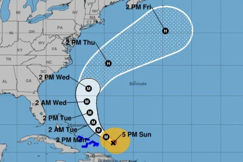
The U.S. East Coast is forecast to have rough ocean conditions through the middle of the week as the storm strengthens, the National Hurricane Center said. Tropical storm warnings were issued for southeast Bahamas, which is about 300 miles east of Miami.
The storm is moving westerly at 13 mph in warm waters as it continues to grow in size and could affect the East Coast this week, the NHC reported in a 5 p.m. EDT update.
"The track guidance is in good agreement on the northward turn but there are differences in how close the hurricane will come to the U.S. East Coast in the 72-hour time frame," NHC forecaster Pasch said in a discussion.
The storm was located about 275 miles northwest of San Juan, Puerto Rico, and about 165 miles east of Grand Turk Island after passing the Leeward Islands on Saturday.
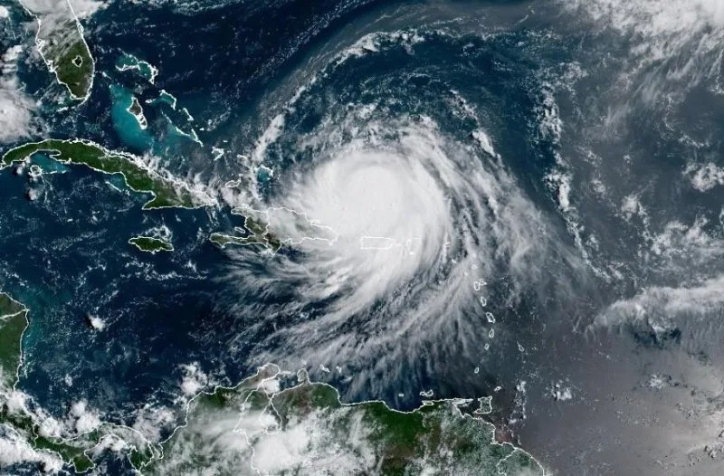
The season's first Atlantic hurricane reached Category 5 status Saturday morning, the highest in the class, after rapidly intensifying overnight. It became a Category 1 hurricane on Friday, the year's fifth named storm.
Erin dropped to a Category 4 and then a 3 overnight into Sunday, but remained a major hurricane. If winds reach 130 mph, Erin would again be listed as a Category 4 hurricane.
"Since the large-scale environment is expected to be favorable for about another day, re-strengthening is possible during that time period," NHC forecaster John Cangialsi. "However, it should be noted that predicting the intensity evolution from internal dynamics are challenging, and models often provide Little reliability in their solutions."
A tropical storm warning remains for the Turks and Caicos Islands and southeast Bahamas. Hurricane-force winds extend up to 50 miles from the center, and tropical-force ones up to 205 miles.
The storm was skirting Puerto Rico rather than hitting it directly.
Erin's motion is expected to decrease in forward speed on Sunday, followed by a gradual turn to the north on Monday and Tuesday, NHC said.
On the forecast track, Erin's core is projected to pass to the east of the Turks and Caicos Islands and southeastern Bahamas on Sunday and Monday.
By late Wednesday and into Thursday night, the storm is forecast to be a few hundred miles west of Bermuda and outside the big tracking cone as it makes a northwest track. Erin is then forecast to travel north hundreds of miles from the East Coast.
Erin's outer bands will produce additional rainfall of 2 to 4 inches across the Virgin Islands and Puerto Rico, with isolated totals of up to 8 inches through Monday. "Locally considerable flash and urban flooding, along with landslides or mudslides, are possible," NHC said.
Also, swells will affect those places, as well as Hispaniola and the Turks and Caicos Islands, during the next couple of days, the agency said.
"Erin is expected to produce life-threatening surf and rip currents along the beaches of the Bahamas, much of the East Coast of the U.S., Bermuda, and Atlantic Canada during the next several days," Cangialsi said.
He said interests along the North Carolina and mid-Atlantic coasts, as well are Bermuda "should monitor the progress of Erin as there is a risk of strong winds associated with the outer rainbands during the middle of next week."
Alex Sosnowski, AccuWeather senior meteorologist, said portions of the North Carolina's Outer Banks and coastal Virginia will experience several feet of storm surge, leading to significant coastal flooding and beach erosion.
He said the closest land mass for Erin to hit could be southeastern Newfoundland in Canada on Friday.
Erin became the first hurricane of the 2025 Atlantic storm season two days ago.
There have been four named storms so far this season in the Atlantic. Tropical Storm Chantal caused major flooding in North Carolina but has been the only of the four to make landfall in the United States this year.
The Atlantic hurricane season began on June 1 and ends on Nov. 30. The peak hurricane season goes from mid-August through September and into mid-October.
Ninety-three percent of hurricane landfalls along the U.S. Gulf Coast and the East Coast have occurred from August through October, the Weather Channel reported in citing data from the National Oceanic and Atmospheric Administration
Last year at this time, there also had been five named storms.


Comments