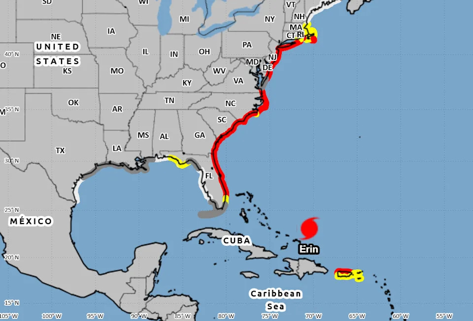
A new system has emerged in the eastern tropical Atlantic, heading westward toward the Leeward Islands as Hurricane Erin continues to spin in the Atlantic Ocean, bringing with it life-threatening surf and rip currents along the beaches of the Bahamas, much of the east coast of the United States, Bermuda and Atlantic Canada.
Erin formed early Friday, Aug. 15, marking the first hurricane of the 2025 Atlantic hurricane season before exploding overnight and strengthening into a Category 5 storm by afternoon Saturday, Aug. 16.
The hurricane is the fifth named storm of what forecasters predicted would be an above-average season. But more notably, it is only the fifth hurricane on record to reach Category 5 strength this early — and the first to do so outside the Gulf or Caribbean, according to WPLG-TV hurricane specialist Michael Lowry.
The system strengthened to sustained winds of 160 mph, but later that day an eyewall replacement cycle caused Erin to weaken slightly.
➤ Weather alerts via text: Sign up to get updates about current storms and weather events by location
Will Hurricane Erin impact Texas?
While Hurricane Erin is not expected to make landfall on the U.S. and is forecast to dissipate in the open Atlantic by early Saturday, Aug. 23, dangerous and life-threatening rip and surf currents are predicted along the East Coast from Florida through Maine this week.
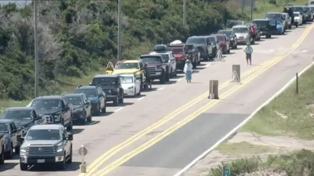
The storm’s rapid intensification has prompted increased emergency measures in North Carolina, and the Outer Banks — a popular summer vacation spot — are now under a state of emergency. Officials mandated evacuations for Hatteras Island, ordering visitors to leave by 10 a.m. Monday, Aug. 18, and residents by 8 a.m. Tuesday, Aug. 19, as forecasters warned of life-threatening rip currents, large swells, coastal flooding and road washouts.
Special note on the NHC cone: The forecast track shows the most likely path of the center of the storm. It does not illustrate the full width of the storm or its impacts, and the center of the storm is likely to travel outside the cone up to 33% of the time.
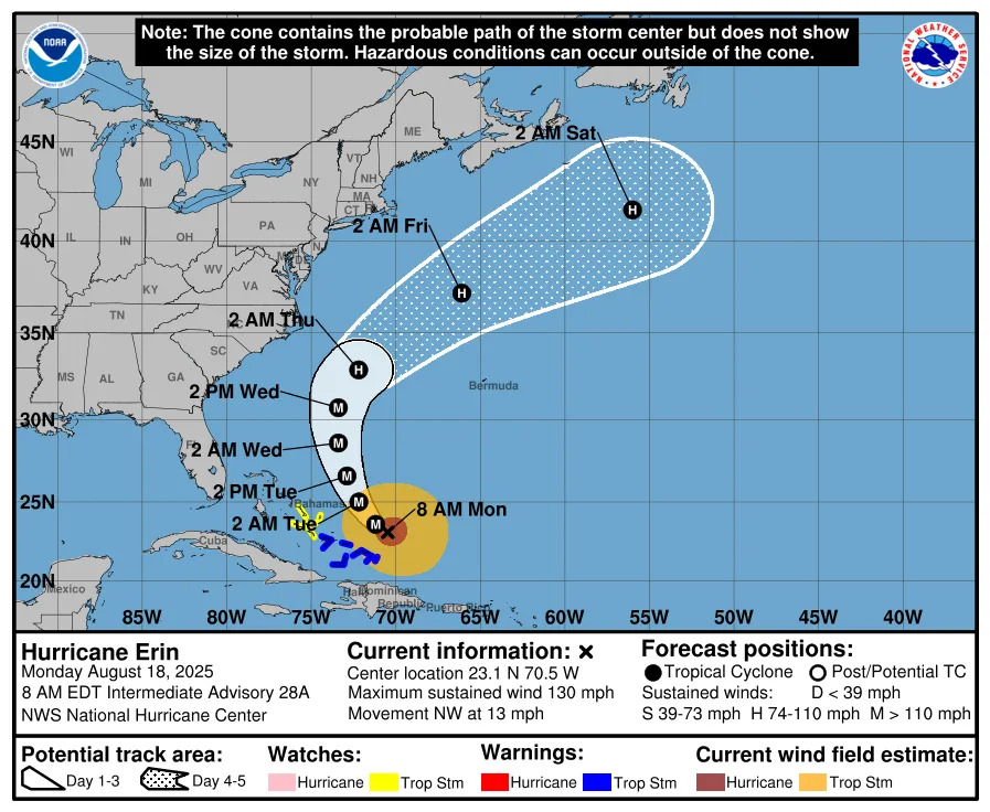
Here's the latest update Aug. 18 on Tropical Storm Erin.
Location: 915 miles south-southeast of Cape Hatteras North Carolina
Maximum sustained winds: 130 mph
Movement: northwest at 13 mph
Pressure: 956 mb
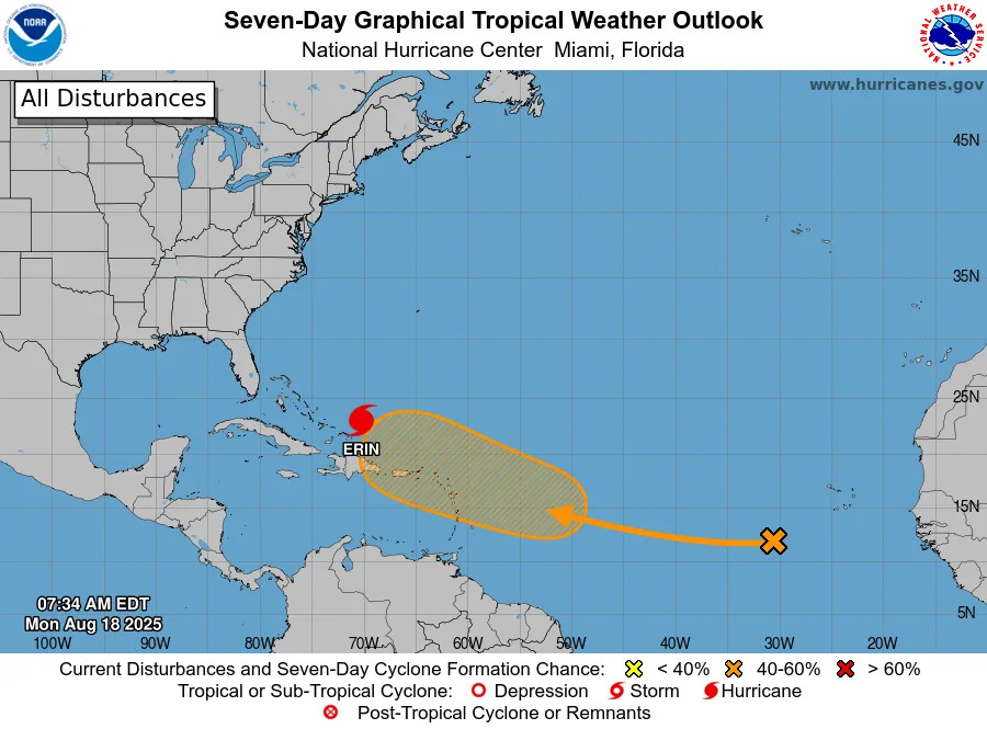
Will the new system impact Texas?
Forecasters said in an Aug. 18 advisory that conditions could allow gradual development, with a tropical depression possibly forming later this week. The system has a 50% chance of formation over the next seven days.
It’s still too early to know if the system will develop or where it will go, though current models show it approaching the Leeward Islands toward the end of the week.
Is the 2025 Atlantic hurricane season off to a slow start?
Erin is the fifth named storm of what forecasters predicted would be an above-average Atlantic hurricane season and is the first to reach hurricane strength this year.
Historically, the first hurricane forms around Aug. 11, the first major hurricane around Sept. 1 and the fifth named storm around Aug. 22, according to AccuWeather.
Forecasters say the season is entering its most active stretch. In their latest forecast, Colorado State University experts stuck to their July outlook of a slightly above-average season: 16 named storms, including eight hurricanes, three of them major.
A "normal" year sees 14 named storms, of which seven become hurricanes.
How does the 2025 Atlantic hurricane season compare to last year in Texas?
For Texas, the season has been relatively quiet so far — a sharp contrast to mid-August last year, when the state was already six weeks past the final storm to impact the state, which saw the two earliest storms of the 2024 hurricane season.
In late June 2024, Tropical Storm Alberto threatened the Texas, and by early July, the Lone Star State was tracking one one of the hardest-hit hurricanes of the season — Hurricane Beryl, which became the earliest Category 5 storm on record before making its third landfall near Matagorda. After that, the remainder of the season was relatively mild for Texas, with no other storm threatening the state.
No storms have directly affected Texas this season, but forecasters warn the season is ramping up as it nears its peak months in August and September.
Last week, on Friday, Aug. 15, Invest 98L — which the National Hurricane Center believed could strengthen into a tropical depression — reached South Texas but brought little impact other than a few inches of rainfall.
Atlantic storm tracker
This forecast track shows the most likely path of the center of the storm. It does not illustrate the full width of the storm or its impacts, and the center of the storm is likely to travel outside the cone up to 33% of the time.
Tropical Storm Erin spaghetti models
Special note about spaghetti models: Illustrations include an array of forecast tools and models, and not all are created equal. The hurricane center uses only the top four or five highest performing models to help make its forecasts.
When is the Atlantic hurricane season?
The Atlantic hurricane season runs from June 1 through Nov. 30.
Ninety-seven percent of tropical cyclone activity occurs during this time period, NOAA said. The season peaks in August and September.
The Atlantic basin includes the northern Atlantic Ocean, Caribbean Sea and Gulf of America, as the Gulf of Mexico is now known in the U.S. per an order from President Trump. NOAA and the National Hurricane Center are now using Gulf of America on its maps and in its advisories.
Prepare now for hurricanes
Delaying potentially life-saving preparations could mean waiting until it’s too late. "Get your disaster supplies while the shelves are still stocked, and get that insurance checkup early, as flood insurance requires a 30-day waiting period," NOAA recommends.
Develop an evacuation plan: If you are at risk from hurricanes, you need an evacuation plan. Now is the time to begin planning where you would go and how you would get there.
Assemble disaster supplies: Whether you’re evacuating or sheltering-in-place, you’re going to need supplies not just to get through the storm but for the potentially lengthy aftermath, NOAA said.
Get an insurance checkup and document your possessions: Contact your insurance company or agent now and ask for an insurance check-up to make sure you have enough insurance to repair or even replace your home and/or belongings. Remember, home and renters insurance doesn’t cover flooding, so you’ll need a separate policy for it. Flood insurance is available through your company, agent, or the National Flood Insurance Program. Act now, as flood insurance requires a 30-day waiting period.
Create a family communication plan: NOAA said to take the time now to write down your hurricane plan, and share it with your family. Determine family meeting places, and make sure to include an out-of-town location in case of evacuation.
Strengthen your home: Now is the time to improve your home’s ability to withstand hurricane impacts. Trim trees; install storm shutters, accordion shutters, and/or impact glass; seal outside wall openings.
Texas weather radar
Texas weather watches and warnings
Stay informed. Get weather alerts via text
Brandi D. Addison covers weather across the United States as the Weather Connect Reporter for the USA TODAY Network. She can be reached at [email protected].
This article originally appeared on Corpus Christi Caller Times: Another new system in Atlantic. Will it hit Texas? See projected path


Comments