The National Hurricane Center is tracking four systems in the Atlantic, according to the latest advisory from the National Hurricane Center.
Hurricane Erin was making its closest approach to the U.S. this morning, with the center about 200 miles east of Cape Hatteras. Large surf and life-threatening rip currents continue to make conditions along the coast from Florida through the mid-Atlantic dangerous.
➤ Live updates: Hurricane Erin unleashes dangerous waves on East Coast, threatening homes
➤ Weather alerts via text: Sign up to get updates about current storms and weather events by location
In the Central Atlantic is a tropical wave with a high chance of becoming a tropical depression this weekend and Invest 99L in the eastern Atlantic, which has a 40% chance of becoming a short-lived tropical depression in the next day or so.
"It’s worth watching the leftover disturbance down the road should it continue west into the Caribbean, but there’s no cause for concern," said Dr. Ryan Truchelut on Aug. 13. Truchelut is the chief meteorologist at WeatherTiger, and works with the USA TODAY Network.
"Otherwise, unfavorable upper-level wind conditions are expected to kick up this week over the Atlantic’s Main Development Region, and the end of August and first week of September should be relatively quiet in the tropics."
A new tropical disturbance popped up on the Hurricane Center's tropical outlook map Thursday morning. The area of low pressure in the central Atlantic has a low chance for development over the next seven days.
The next named storm of the Atlantic hurricane season will be Fernand.
Here's the latest advisory from the National Hurricane Center as of 8 a.m. Thursday, Aug. 21:
See projected path for Hurricane Erin
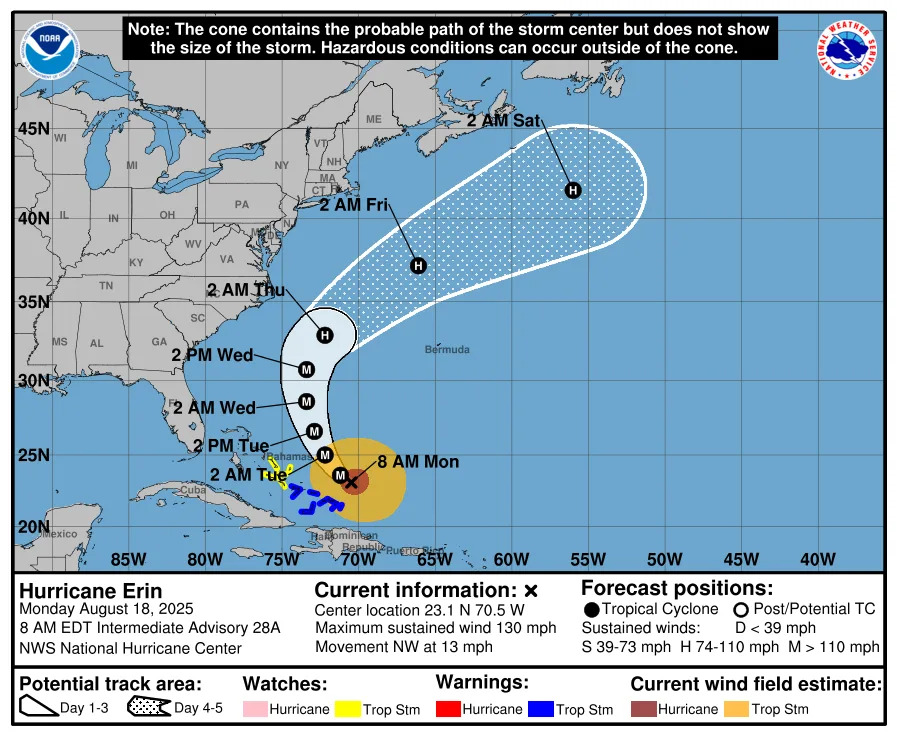
Special note on the NHC cone: The forecast track shows the most likely path of the center of the storm. It does not illustrate the full width of the storm or its impacts, and the center of the storm is likely to travel outside the cone up to 33% of the time.
NOAA hurricane tracker: See spaghetti models for Hurricane Erin
Special note about spaghetti models: Illustrations include an array of forecast tools and models, and not all are created equal. The hurricane center uses only the top four or five highest performing models to help make its forecasts.
What tropical waves, disturbances are in Atlantic basin now?
Tropical wave: An area of showers and thunderstorms associated with a tropical wave located a few hundred miles east of the Leeward Islands has changed little over the past several hours. Environmental conditions appear conducive for further development of this system, and a tropical depression is likely to form this weekend while it moves near or to the north of the northern Leeward Islands.
Formation chance through 48 hours: medium, 40 percent
Formation chance through 7 days: high, 70 percent
Invest 99L: Showers and thunderstorms associated with a tropical wave located several hundred miles west-southwest of the Cabo Verde Islands show some signs of organization. Environmental conditions appearmarginally favorable for additional development over the next day or so while the system moves west-southwestward at around 15 mph, and a short-lived tropical depression could form. In a couple of days, environmental conditions are expected to become unfavorable for further development.
Formation chance through 48 hours: medium, 40 percent
Formation chance through 7 days: medium, 40 percent
Area of low pressure: A small area of low pressure located about 1200 miles southwest ofthe Azores is producing limited showers and thunderstorms. Upper-level winds are only marginally conducive for development while the system moves slowly eastward over the next couple of days.
Formation chance through 48 hours: low, 30 percent.
Formation chance through 7 days: low, 30 percent.
Spaghetti models for Invest 99L
Special note about spaghetti models: Illustrations include an array of forecast tools and models, and not all are created equal. The hurricane center uses only the top four or five highest performing models to help make its forecasts.
Is another hurricane heading toward Florida?
It's still too early to tell whether the tropical wave in the central Atlantic or Invest 99L pose a threat to Florida or the U.S. but forecasters said a U.S. threat is unlikely.
"Unfavorable upper-level wind conditions are expected to kick up this week over the Atlantic’s Main Development Region, and the end of August and first week of September should be relatively quiet in the tropics," said Truchelut.
➤ Hurricane forecast: Erin brings thunderous surf, likely quiet spell till mid-September
Mid-August through mid-October is the busiest portion of hurricane season and officials regularly urge residents to always be prepared for storms.
What is an invest?
Short for investigation, the National Hurricane Center uses the term invest for areas of low pressure it is monitoring for potential development into a tropical depression or storm.
Invests are not tropical depressions or tropical storms. They're usually clusters of showers and thunderstorms, and just because they've been designated as an invest does not guarantee they'll strengthen into a tropical storm or hurricane.
Invests run from 90 to 99, followed by a letter: L for the Atlantic basin and E for those in the eastern Pacific. After 99, it starts over again, and the next invest would be 90.
Once something has been designated as an invest, specialized data sets and computer models can begin, including scheduling hurricane hunter aircraft missions and running spaghetti models.
What do the colored, hatched areas on the NOAA map mean?
The hatched areas on the National Hurricane Center's tropical outlook map indicate "areas where a tropical cyclone — which could be a tropical depression, tropical storm or hurricane — could develop," said National Hurricane Center Deputy Director Jamie Rhome.
The colors make it visibly clear how likely a system could develop, with yellow being low, orange medium and red high.
The National Hurricane Center generally doesn't issue tropical advisories until there is a named storm, but there is an exception.
"If a system is near land and there is potential for development, the National Hurricane Center won't wait before it issues advisories, even if the system hasn't become an actual storm. This gives residents time to prepare," Rhome said.
Florida weather radar for Aug. 21, 2025
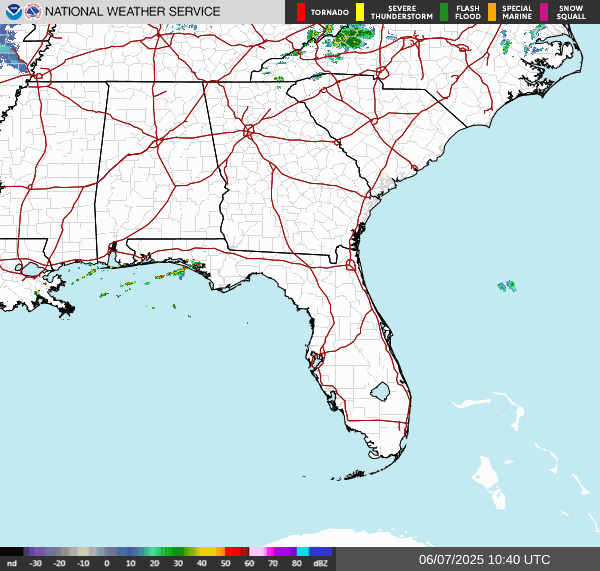
Weather watches and warnings issued in Florida
When is the Atlantic hurricane season?
The Atlantic hurricane season runs from June 1 through Nov. 30.
Ninety-seven percent of tropical cyclone activity occurs during this time period, NOAA said.
The Atlantic basin includes the northern Atlantic Ocean, Caribbean Sea and Gulf of America, as the Gulf of Mexico is now known in the U.S. per an order from President Trump. NOAA and the National Hurricane Center are now using Gulf of America on its maps and in its advisories.
When is the peak of hurricane season?
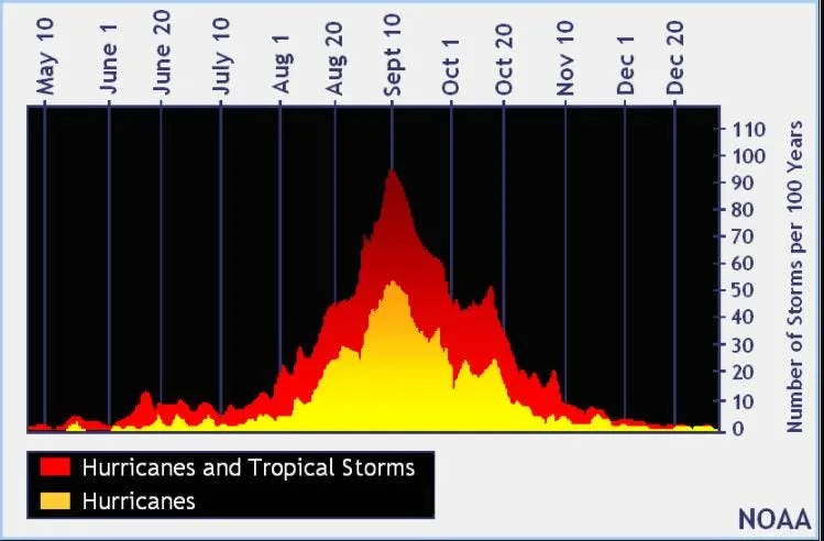
The peak of the season is Sept. 10, with the most activity happening between mid-August and mid-October, according to the Hurricane Center.
Hurricane names for 2025 season
Here are the names for the 2025 Atlantic hurricane season, along with how to pronounce them.
Andrea(June 20)Barry(June 29)Chantal(July 5)Dexter: (Aug. 3)Erin: (Aug. 11; hurricane Aug. 15; major hurricane Aug. 16)
Fernand: fair-NAHN (sixth-named storm historically forms Aug. 29)
Gabrielle: ga-bree-ELL
Humberto: oom-BAIR-toh
Imelda: ee-MEHL-dah
Jerry: JEHR-ee
Karen: KAIR-ren
Lorenzo: loh-REN-zoh
Melissa: meh-LIH-suh
Nestor: NES-tor
Olga: OAL-guh
Pablo: PAHB-lo
Rebekah: reh-BEH-kuh
Sebastien: se-BAS-tee-en
Tanya: TAHN-yuh
Van: van
Wendy: WEN-dee
National Hurricane Center map: See what forecasters are watching now
Systems currently being monitored by the National Hurricane Center include:
Interactive map: Hurricanes, tropical storms that have passed near your city
Stay informed. Get weather alerts via text
What's next?
We will update our tropical weather coverage daily.
Download your local site's app to ensure you're always connected to the news. And look for our special subscription offers here.
This article originally appeared on Treasure Coast Newspapers: NOAA tracking Hurricane Erin, Invest 99L, 2 others. See impacts, paths


Comments