No disturbance in the Atlantic looks like it will pose a threat to Florida or the Caribbean anytime soon, giving the state a bit of breathing room as Hurricane Erin leaves the region on its northern path.
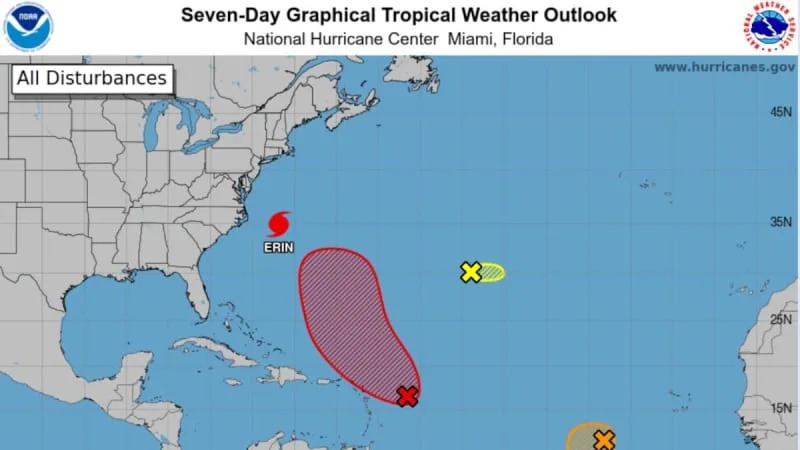
On Thursday, the National Hurricane Center once again upped the chances that the nearest disturbance could develop into a tropical depression this weekend as it approaches the easternmost Caribbean islands. As of the 8 a.m. update, the system had a 70% chance of developing in the next seven days and a 40% chance in the next two days.
The same mass of cool air that should bring welcoming fall-like temperatures to most of the U.S. in the next few days (not Florida, sorry) is expected to help steer any would-be storm that does form out to sea, , a similar L-shaped forecast track to Hurricane Erin.
The other tropical wave, closer to Africa, was tagged as invest 99L a few days ago — an internal term that allows the hurricane center to sic some of its powerful hurricane models on the small system and help predict where and when it may form.
As of Thursday morning, forecasters held its chances of developing into a tropical depression or storm at 40% in the next two to seven days. They say a “short-lived” tropical depression could spawn in the brief period of good conditions the little system will see in the next few days.
Other long-term storm models, a minority of them, suggest the system could survive even after its window of good conditions closes and potentially head farther west into the Caribbean as a weak tropical storm.
“99L has a short shelf life apparently, but some guidance tries to ramp it over time. If it can survive easterly shear and make it to the islands early next week it may not just disappear,” wrote the Weather Channel’s Jim Cantore on X Thursday.
Thursday morning, forecasters also tagged a brand new disturbance located between the first two. They gave this one a 30% shot of forming a tropical depression or storm in the next two to seven days as it moves eastward.
The next name on the storm list is Fernand.
The latest on Hurricane Erin
North Carolina’s Outer Banks were feeling Erin on Thursday morning, as the storm brought in at least 2 feet of storm surge over land, sloshing roads and homes on the vulnerable barrier islands.
Virginia and parts of Maryland were also seeing storm surge from the massive storm, which remained offshore but is so large that its outer bands were bringing in wave after wave of tropical storm-force winds and high surf to the coastal communities — a trend that is expected to continue throughout the day as Erin creeps north.
Hurricane Erin’s track leaned more west as it shot along the Eastern seaboard, sparing Bermuda but scraping along several Northeastern states’ coasts.
By Friday, the hurricane is expected to curve back northeast and head out to sea, where the cooler northern waters will slow it down to at least a tropical storm by early next week.
• • •
Tampa Bay Times hurricane coverage 2025
Here’s a look at the 2025 hurricane season forecasts so far.
What to know about river flooding in Tampa Bay this hurricane season.
Here are the lessons you learned from Tampa Bay’s historic 2024 hurricane season.


Comments