Tight on time? This story is for you. It's an abbreviated, text view of what's happening with Hurricane Erin. Click here for more details and to see the latest spaghetti models.
Sign up to get weather alerts via text based on your interests or location.
Hurricane Erin continues to move northeast, staying well offshore and away from the U.S. coast. Although it passed Florida without making landfall on Wednesday, August 20, the storm is still having an impact on the state's beaches.
The National Weather Service has issued extended hazardous weather advisories for all beaches in Southeast Georgia and Northeast Florida. Including, a High Rip Current Risk remains in effect through 8 p.m. on Friday, August 22, while a High Surf Advisory is in place until 8 p.m. on Wednesday, August 21. Here's what to expect:
National Weather Service warns of ‘Hazardous Weather Conditions’ in Jacksonville:
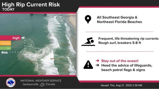
Frequent, life-threatening rip currents
Rough surf with breakers between 5–8 feet
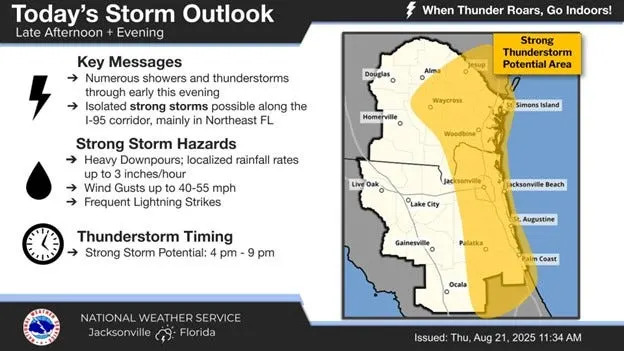
Numerous showers and thunderstorms through early evening
Isolated strong storms likely along the I-95 corridor, especially in Northeast Florida
Additional thunderstorm potential between 4 p.m. and 9 p.m.
What are Hurricane Erin's local impacts today?
High Rip Current Risk through Friday
High Surf & Beach Erosion Today NE Florida
Small Craft Advisory through Friday
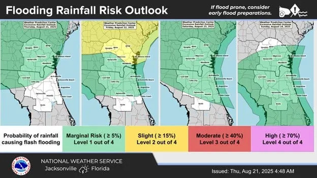
Thunderstorm and flooding Risks
Widespread afternoon & evening storms Friday through Weekend
Strong storm hazards: Gusty winds & frequent lightning
Local flooding rain risk Friday through weekend
NWS is warning of 'slight risk of flooding' Friday
Is there another hurricane coming toward Florida?
The National Hurricane Center is tracking four systems in the Atlantic, according to the latest advisory from the National Hurricane Center.
Hurricane Erin was making its closest approach to the U.S. this morning, with the center about 200 miles east of Cape Hatteras. Large surf and life-threatening rip currents continue to make conditions along the coast from Florida through the mid-Atlantic dangerous.
➤ Hurricane forecast: Erin brings thunderous surf, likely quiet spell till mid-September
Where is Hurricane Erin right now?
At 11 a.m., Erin was located 260 miles east of Cape Hatteras, North Carolina, and 410 miles west-northwest of Bermuda.
➤ Spaghetti models for Hurricane Erin
How strong is Hurricane Erin?
At 11 a.m., maximum sustained winds were at 100 mph, making Erin a Category 2 storm.
How big is Hurricane Erin?
Erin is a very large hurricane.
Hurricane-force winds extend outward up to 105 miles from the center and tropical-storm-force winds extend outward up to 320 miles.
Watches, warnings issued for Florida, US
No watches or warnings are in effect for Florida.
A storm surge warning is in effect for:
Cape Lookout to Duck, North Carolina
A tropical storm warning is in effect for:
Beaufort Inlet, North Carolina to Chincoteague, Virginia, including Pamlico and Albemarle Sounds
What impacts is Hurricane Erin having on Florida?
Erin continues to bring frequent and life-threatening rip currents to Northeast Florida beaches. Breakers could be 5 to 8 feet.
Along east central Florida beaches, life-threatening rip currents continue Thursday, along with 5-7 foot breakers.
What should you do if you live in Florida?
Officials continue to urge people to stay out of the ocean to avoid the dangerous surf and life-threatening rip currents.
Remember, the busiest period of hurricane season will last through mid-October.
Now is the time to:
Keep an eye on weather updates. and make sure you monitor the latest conditions.
What's next?
We will continue to update our tropical weather coverage daily.
Download your local USA TODAY Network newspaper site's app to ensure you're always connected to the news. And look for our special subscription offers here.
This story has been updated to include new information.
This article originally appeared on Florida Times-Union: Forecast: Rip currents, thunderstorms and flooding. What to expect?


Comments