This season’s first hurricane – and the first of the Trump administration’s new era of meteorological austerity – has been making its closest pass to the US this week.
On Friday morning, weaker than days earlier, it is still a large storm, heading north-east, and impacting the US east coast with threats of coastal flooding.
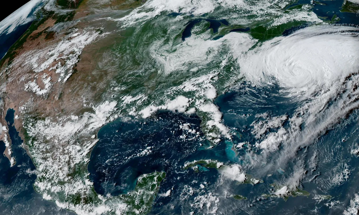
But at its peak earlier this week, Hurricane Erin was one of the strongest and largest hurricanes ever recorded in the Atlantic Ocean.
Worryingly, Hurricane Erin also intensified at nearly the fastest rate ever seen in the Atlantic basin last weekend, going from a tropical storm to category 5 in about 24 hours. Only a handful of hurricanes in history have strengthened so quickly into as large and intense a storm as Erin.
Erin’s extremely rapid intensification underscores the danger of hurricane season in an era of climate crisis, a diminished Fema and an understaffed National Weather Service.
Although Hurricane Erin’s impact has been limited to some heavy rains in Puerto Rico and huge waves along the east coast, many emergency managers in storm-weary Florida took it as a warning sign.
“My initial thoughts were: thank you, Jesus, it’s not coming to Florida,” said Heather Henderson-Scheu, the emergency management director of Suwannee county, Florida, which is about 80 miles east of Tallahassee.
“This is becoming the new reality,” said Henderson-Scheu. “It’s really concerning because it doesn’t give you as much time to prepare, even though we’re inland.”
In 2023, Hurricane Idalia grew from a category 1 to a category 4 in less than 24 hours, becoming the strongest storm to affect Florida’s Big Bend region in more than 70 years. Including Idalia, four hurricanes have made landfall in Florida in less than two years. All four of them have tracked near or over Suwannee county, home to more than 50,000 people and the heart of the state’s poultry industry, which has suffered greatly since Helene’s landfall last year.
“We got calls all weekend about Erin,” said Henderson-Scheu. “After what we’ve been through, people are real eager to not stay in their houses any more.”
Rapid intensification just before landfall – defined as a windspeed increase of at least 35mph in less than 24 hours – is now happening five times more often than it did in the 1980s, a trend that scientists have recently attributed to global warming.
The waters where the intensification happened were record warm, a record that was made at least 100 times more likely due to climate change per an analysis from Climate Central. Those record warm waters likely added about 9 mph to its peak wind speed, enough to boost it from a category 4 to a category 5.
The ability for scientists to forecast the conditions that lead to rapid intensification has improved greatly over the past 10 years or so, in part because these conditions are happening much more often now. There have been 42 hurricanes that have reached category 5 in the Atlantic since records began in 1851, and 11 of those have happened in the past 10 years.
Erin’s intensification rate was not perfectly captured by the National Hurricane Center in advance, nor by any of the computer models it uses. Emergency managers told the Guardian they don’t need perfect forecasts to take appropriate actions in advance.
“The situation just calls for understanding that our expected impacts can change very rapidly,” said Megan Milanese, the emergency management director for Lake county, Florida, just west of Orlando. “So, typically what we do is we plan for the worst situation and hope for the better one, and that way we have that preparation in place if the worst thing occurs.”
Emergency planning under that kind of uncertainty isn’t a new struggle for emergency managers. During Hurricane Ian in 2022, initial forecasts showed the storm would track parallel to Florida’s west coast, which meant that small changes in the storm’s expected path resulted in large changes to the storm’s expected landfall location.
“We’re all sort of expectant of these sort of small shifts in the grand scheme of Earth, but big changes for us,” said Lane Schneider, the emergency management director for Hardee county, Florida, east of Sarasota. “A lot of times, it just doesn’t necessarily matter where in the state it goes because we’re also used to the storms just being large and preparing for it anyways.”
The onslaught of hurricanes in recent years have helped Henderson-Scheu and her team hone their county’s hurricane plans to the point that it now takes just several hours to coordinate resources with the governor’s office and the county’s school system, open up shelters, and begin the evacuation process.
“What we’re trying to do in our community is change that mindset of it’s not going to ever happen here,” said Henderson-Scheu. “Now it’s about *when* it happens here, because it has happened here, and because of the temperatures of the ocean, it is going to continue to happen here. So we’re really pushing preparedness.”
Eric Holthaus is a meteorologist and climate journalist based in Minnesota


Comments