The worst of the effects of Hurricane Erin are over in Massachusetts, but high surf advisories and a coastal flood warning remain in effect.
For most of this week, Massachusetts has already been experiencing the impacts from Erin, including rip currents and surf conditions.
Some communities in the Bay State closed beaches to swimmers, including South Shore beaches on Nantucket, Horseneck Beach in Westport and some Scituate beaches.
So where is Erin now? And what effects from the storm remain?
Here's what to know.
What effects from Erin are still being felt in MA?
A coastal flood advisory remains in place until late tonight (Friday, Aug. 22), and high surf warnings will be maintained through 8 p.m. Saturday.
Those warnings are specifically for Plymouth, and Essex counties.
A statement from the National Weather Service says, people in those areas can expect, "Large breaking waves of 10 to 15 feet on ocean beaches, rough surf will likely cause some splashover onto coastal roads around the time of high tide. Dangerous swimming and surfing conditions and localized beach erosion."
Rip currents, which have been an issue at beaches in Massachusetts, will still be a problem through Saturday.
What are rip currents?
They are powerful channels of fast-moving water, and they have killed about 50 people in the U.S. so far this year, according to a release last week from AccuWeather.
If you are caught in a rip current, officials advise you to swim parallel to the shore until you are out of the channel, AccuWeather noted in the release.
What does the weather forecast look like going forward this week?
According to the National Weather Service's online forecaster's discussion, "Seasonable weather expected today and Saturday with breezy conditions. Turning more unsettled for Sunday night through Monday chances for showers and thunderstorms before dry weather returns midweek."
Where is Hurricane Erin now?
Hurricane Erin is entering the first stages of a post-tropical transition as it continues to move away from the eastern coast of the United States, although swimming at many beaches is likely to remain dangerous for a few more days, according to the National Hurricane Center.
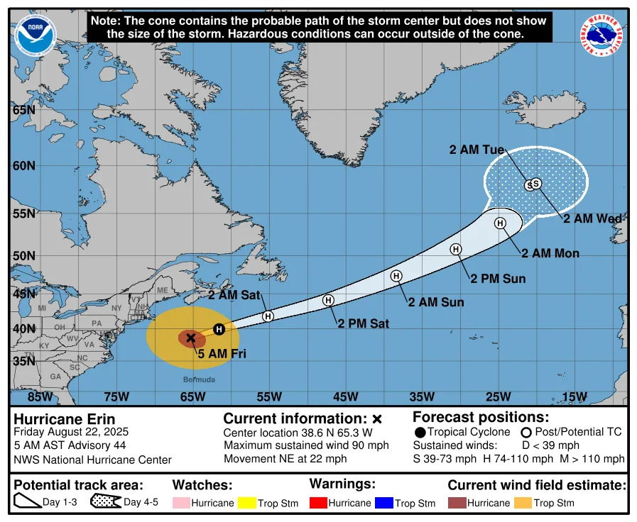
The latest Hurricane Weather Center advisory, released at 5 a.m. on Aug. 22, shows that Erin is located about 425 miles south-southwest of Halifax, Nova Scotia with maximum sustained winds near 90 mph with higher gusts. Forecasters predict that Erin will likely transition to a post-tropical storm by Friday night, Aug. 22, but will continue to be a "powerful hurricane-force low pressure system" through the weekend.
Hurricane Erin path tracker
This forecast track shows the most likely path of the center of the storm. It does not illustrate the full width of the storm or its impacts, and the center of the storm is likely to travel outside the cone up to 33% of the time.
Hurricane Erin spaghetti models
Illustrations include an array of forecast tools and models, and not all are created equal. The hurricane center uses only the top four or five highest-performing models to help make its forecasts.
What's the hurricane outlook for the 2025 season?
The AccuWeather 2025 Atlantic hurricane season forecast is predicting 13-18 named storms, including 7-10 hurricanes, adding "Three to six direct U.S. impacts are forecast, the same range as last year’s catastrophic season with six landfalls."
The report noted that the climatological peak of hurricane season begins Sept. 10.
What is the NOAA forecast on hurricanes in 2025?
NOAA is forecasting a range of 13 to 19 total named storms. Of those, 6 to 10 are forecast to become hurricanes, including 3 to 5 major hurricanes.
What are the remaining names for hurricanes in 2025?
According to the National Hurricane Center, they are Fernand, Gabrielle, Humberto, Imelda, Jerry, Karen, Lorenzo, Melissa, Nestor, Olga, Pablo, Rebekah, Sebastien, Tanya, Van and Wendy.
USA Today Network reporter Gabe Hauari contributed to this article.
This article originally appeared on Cape Cod Times: Hurricane Erin updates: What to expect now in MA. See tracker


Comments