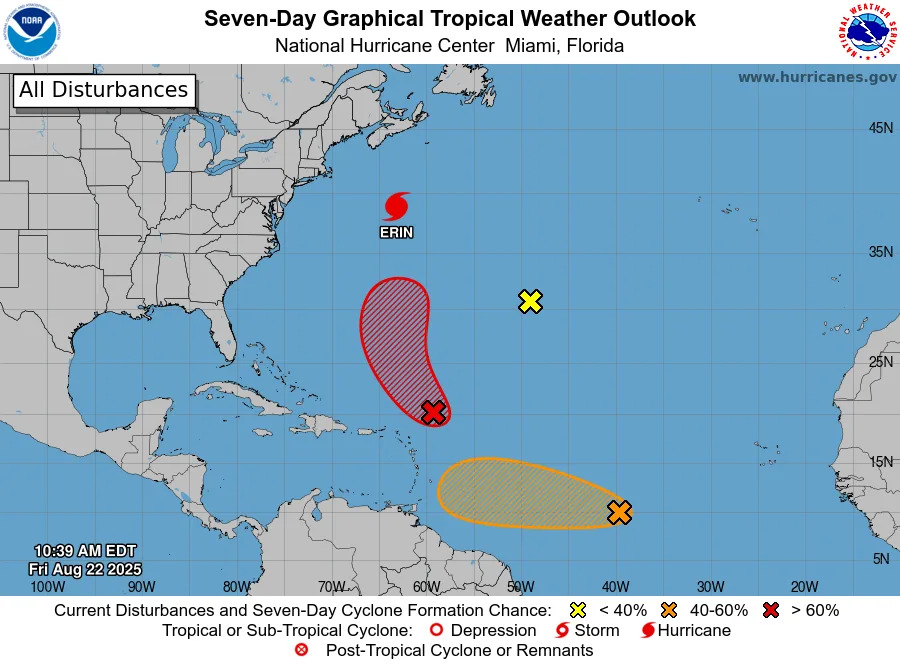
Hurricane Erin is entering the first stages of a post-tropical transition as it continues to move away from the eastern coast of the United States, although swimming at many beaches is likely to remain dangerous for a few more days, according to the National Hurricane Center.
The latest Hurricane Weather Center advisory, released at 5 a.m. ET on Aug. 22, shows that Erin is located about 425 miles south-southwest of Halifax, Nova Scotia with maximum sustained winds near 90 mph with higher gusts. Forecasters predict that Erin will likely transition to a post-tropical storm by Friday night, Aug. 22, but will continue to be a "powerful hurricane-force low pressure system" through the weekend.
Erin is currently moving northeastward at 22 mph, with a turn toward the east-northeast expected later on Friday, August 22. The storm is then forecast to turn back toward the northeast on Sunday, August 24. The center of Erin is anticipated to pass south of Atlantic Canada throughout the day on Aug. 22 and then race across the north Atlantic waters.
Will Invest 90L impact Texas? See path
Erin is not the only system currently spinning in the Atlantic Ocean. The NHC said in an Aug. 22 advisory it is tracking three other systems.
An area of disorganized showers and thunderstorms associated with a tropical wave is located a few hundred miles east-northeast of the northern Leeward Islands.
Environmental conditions appear conducive for further development of this system, currently labeled as Invest 90L, and a tropical depression is likely to form this weekend as it moves northwestward and then northward, between the Lesser Antilles and Bermuda. Forecasters give the system a 70% chance of formation through the next 48 hours.
A second tropical wave, located about a thousand miles west-southeast of the Cabo Verde Islands, is producing showers and thunderstorms that remain well organized, according to the hurricane center.
This system could become a tropical depression at any time, but NHC forecasters stated that the latest satellite-derived wind data indicate the system lacks a well-defined circulation center. The system is also expected to move into a less conducive environment later Friday, Aug. 22, through Saturday, but could reach a slightly more favorable environment late this weekend or early next week.
The hurricane center gives this system a 60% chance of formation through the next seven days.
Lastly, a small area of low pressure located well southwest of the Azores is moving through a dry environment and only producing occasional showers. Upper-level winds appear unfavorable, according to the hurricane center, and development chances are decreasing. This system is likely to dissipate over the next day or so.
It's too early to determine if any will even form, and whether they'll reach Texas — or even the U.S. — or they'll take a path into the open Atlantic similar to Hurricane Erin.
Atlantic storm tracker
This forecast track shows the most likely path of the center of the storm. It does not illustrate the full width of the storm or its impacts, and the center of the storm is likely to travel outside the cone up to 33% of the time.
Tropical Storm Erin spaghetti models
Special note about spaghetti models: Illustrations include an array of forecast tools and models, and not all are created equal. The hurricane center uses only the top four or five highest performing models to help make its forecasts.
How does the 2025 Atlantic hurricane season compare to last year in Texas?
For Texas, the season has been relatively quiet so far — a sharp contrast to mid-August last year, when the state was already six weeks past the final storm to impact the state, which saw the two earliest storms of the 2024 hurricane season.
In late June 2024, Tropical Storm Alberto threatened the Texas, and by early July, the Lone Star State was tracking one one of the hardest-hit hurricanes of the season — Hurricane Beryl, which became the earliest Category 5 storm on record before making its third landfall near Matagorda. After that, the remainder of the season was relatively mild for Texas, with no other storm threatening the state.
No storms have directly affected Texas this season, but forecasters warn the season is ramping up as it nears its peak months in August and September.
When is the Atlantic hurricane season?
The Atlantic hurricane season runs from June 1 through Nov. 30.
Ninety-seven percent of tropical cyclone activity occurs during this time period, NOAA said. The season peaks in August and September.
The Atlantic basin includes the northern Atlantic Ocean, Caribbean Sea and Gulf of America, as the Gulf of Mexico is now known in the U.S. per an order from President Trump. NOAA and the National Hurricane Center are now using Gulf of America on its maps and in its advisories.
Prepare now for hurricanes
Delaying potentially life-saving preparations could mean waiting until it’s too late. "Get your disaster supplies while the shelves are still stocked, and get that insurance checkup early, as flood insurance requires a 30-day waiting period," NOAA recommends.
Develop an evacuation plan: If you are at risk from hurricanes, you need an evacuation plan. Now is the time to begin planning where you would go and how you would get there.
Assemble disaster supplies: Whether you’re evacuating or sheltering-in-place, you’re going to need supplies not just to get through the storm but for the potentially lengthy aftermath, NOAA said.
Get an insurance checkup and document your possessions: Contact your insurance company or agent now and ask for an insurance check-up to make sure you have enough insurance to repair or even replace your home and/or belongings. Remember, home and renters insurance doesn’t cover flooding, so you’ll need a separate policy for it. Flood insurance is available through your company, agent, or the National Flood Insurance Program. Act now, as flood insurance requires a 30-day waiting period.
Create a family communication plan: NOAA said to take the time now to write down your hurricane plan, and share it with your family. Determine family meeting places, and make sure to include an out-of-town location in case of evacuation.
Strengthen your home: Now is the time to improve your home’s ability to withstand hurricane impacts. Trim trees; install storm shutters, accordion shutters, and/or impact glass; seal outside wall openings.
Texas weather radar
Texas weather watches and warnings
Stay informed. Get weather alerts via text
Brandi D. Addison covers weather across the United States as the Weather Connect Reporter for the USA TODAY Network. She can be reached at [email protected].
This article originally appeared on Corpus Christi Caller Times: Invest 90L emerges. Will it impact Texas? See projected path


Comments