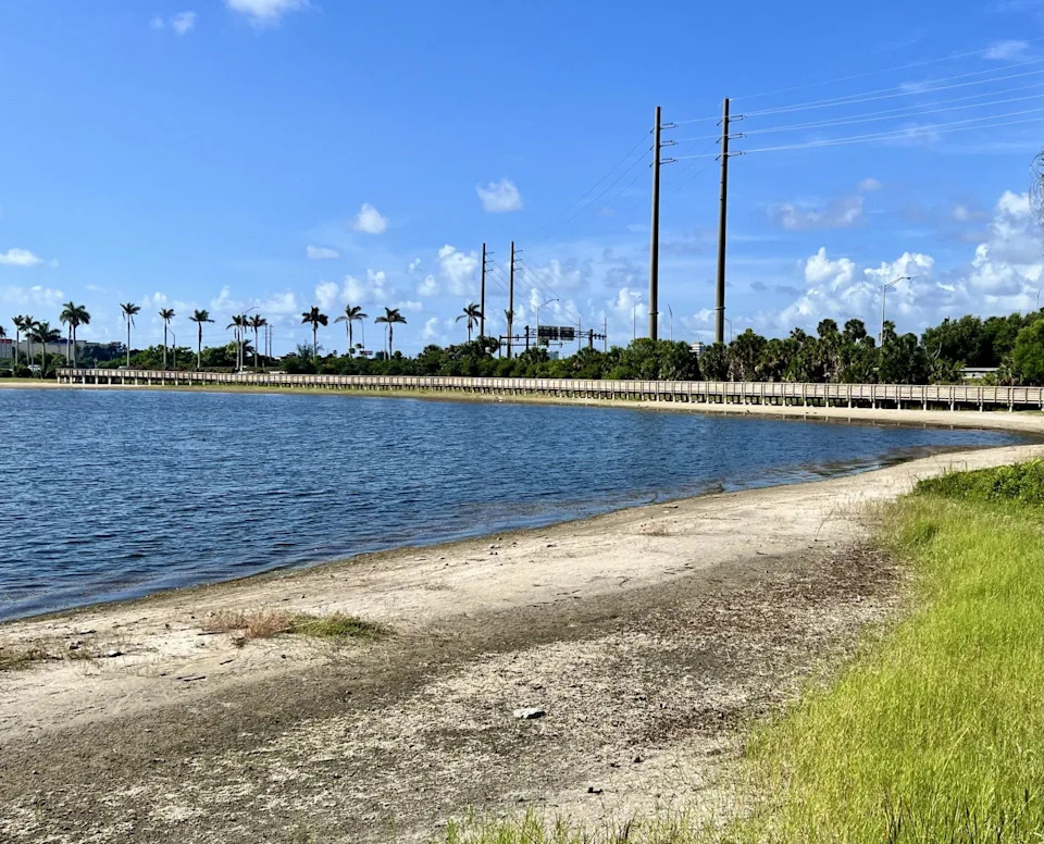
More than two months into South Florida’s wet season, the region remains in a stubborn drought with water managers now looking to the tropics to stir up a sloppy system able to make up for a deficit of more than a foot of rain in some areas.
The parched conditions aren’t likely to trigger enhanced water restrictions in the near term, but it could happen later in the year if Lake Okeechobee levels aren’t significantly buoyed before water demand increases to irrigate crops and residential landscaping.
West Palm Beach, which relies primarily on surface water to keep its taps flowing, uses Lake Okeechobee as a backup water source. Farmers also use Lake O water to irrigate their fields.
“The bottom line is, if you are not getting water from the sky in the form of rainfall and you have high evaporation, you have to get it from a supplemental source,” said Tommy Strowd, the Lake Worth Drainage District's executive director. “The worst-case scenario is you have a deficit in the wet season and then go into dry season with drought.”
The dry season begins Oct. 15 and runs through May 15.
As of July 31, West Palm Beach was down 12.19 inches of rain for the year as measured at Palm Beach International Airport, ranking 2025 the 14th driest year in 126 years of records, according to the Southeast Regional Climate Center. Fort Lauderdale has a rain deficit of 14.09 inches for the year and Miami is down about 4.5 inches.
Hurricane Season 2025: How the hurricane forecast cone changed this year
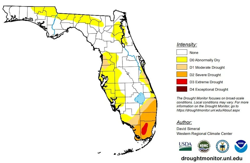
Palm Beach, Broward, Miami-Dade and Collier counties are the only areas in the state with severe to extreme drought, the second and third levels on a four-tier drought scale, according to a U.S. Drought Monitor report released July 31.
Sammy Hadi, a meteorologist with the National Weather Service office in Miami, said it’s unusual for drought to persist this deep into the wet season, a time when South Florida gets between 60% and 70% of its rainfall.
But consistent easterly winds this summer from a strong Bermuda High have pushed the traditional afternoon thunderstorms farther inland, leaving the coast dry, hot and humid.
The average temperature for July was 84 degrees in West Palm Beach, which is a degree warmer than normal, but 25 of the 31 days were above 90 degrees, including July 31, which hit a scorching 95 — one degree off the record of 96 set for that day in 1990. The normal daytime high temperature for West Palm Beach in July is 90 degrees.
“The reality is that there may be a thunderstorm one day that produces a lot of rainfall, but it’s been dry for months and we have been below average for months, so it’s going to take more than one or two thunderstorms to get out of this drought,” Hadi said. “If we don’t see a good amount of rainfall moving forward, we won’t be in good shape this dry season.”
There is no drought in areas of North and Central Florida, and most of the southwest coast is considered only “abnormally dry.”
An outbreak of Saharan dust in late May through mid-June dried up some of the expected rainfall with West Palm Beach getting just 5 inches of rain in June. That's 3.6 inches below average. July, which is typically the peak of Saharan dust season, saw the lowest amounts since 2002, said Michael Lowry, a hurricane expert with South Florida ABC-TV affiliate WPLG-Channel 10 in his Eye on the Tropics blog.
"Dust concentrations to end July were running as low as we’ve seen them in late September, so with the exception of the occasional outbreak, don’t expect dust to be a big player this hurricane season," Lowry said.
While rain chances are between 30% and 60% through the first full week of August, Hadi said the Bermuda High’s easterly breezes remain fairly consistent in the short term. The Climate Prediction Center’s forecast for Aug. 6 through Aug. 14 is leaning toward Florida getting above normal rainfall for the period.
“In order to really see a change, we will have to see a tropical wave or something similar,” Hadi said about alleviating the drought.
2025 Hurricane Season Guide: Storm preparedness tips, supply list, evacuation zones
Strowd said water levels in canals, which feed to community lakes and keep saltwater intrusion at bay, are starting to drop and will need supplemental water soon.
“We are just kind of coasting,” he said. “The only kind of weather system that can get us some relief will be tropical activity.”
This hurricane season, which began June 1, is about average based on the three named storms that have formed. But they were short-lived and the amount of accumulated cyclone energy, or ACE, is at just 1.9 compared to the average of 9.8. ACE is a measure of the virility and longevity of a tropical cyclone.
The National Hurricane Center has nothing on its radar through the first week of August, but it is the beginning of the peak time for hurricane season, when tropical waves begin rolling off the coast of Africa in earnest.
Despite the quiet start, meteorologists aren’t letting their guard down.
“Years like 2004 have ended July without a single named storm and quickly woken up to give us blockbuster hurricane seasons,” Lowry said. “So, we stay vigilant and don’t let the early whims of the hurricane season fool us.”
Three hurricanes made landfall in Florida in 2004 — Charley, Frances and Jeanne. Hurricane Ivan devastated Pensacola but technically made landfall in Alabama.
Kimberly Miller is a journalist for The Palm Beach Post, part of the USA Today Network of Florida. She covers real estate, weather, and the environment. Subscribe to The Dirt for a weekly real estate roundup. If you have news tips, please send them to [email protected]. Help support our local journalism, subscribe today.
This article originally appeared on Palm Beach Post: Palm Beach County water restrictions: Not with drought but maybe winter


Comments