The Brief
A flood watch is in effect for north and central Georgia through 8 p.m. Monday, with up to five additional inches of rain possible in some areas.
Saturated ground and wind gusts up to 25 mph have increased the risk of downed trees and localized flooding, particularly in metro Atlanta.
Scattered showers will continue through Tuesday morning, with little sunshine expected until midweek; temperatures will remain below average in the low 70s.
ATLANTA - A flood watch has been issued for much of north and central Georgia as heavy rains continue to drench the region, with more storms expected through Monday evening. The National Weather Service issued the alert Sunday morning, warning of potentially hazardous conditions due to already saturated ground and more precipitation on the way.
What we know
The watch will remain in effect until 8 p.m. Monday. FOX 5 Storm Team meteorologist Alex Forbes said the area has already received between one and three inches of rain, and an additional two to four inches are possible, with some isolated areas potentially seeing up to five more inches.
"This is going to be a prolonged rain event," Forbes said. "We’re going to continue seeing scattered showers throughout Sunday morning, tapering off a bit this afternoon, but more rain is expected to push in overnight and into Monday."
In some areas, the ground is already saturated, increasing the risk of flash flooding and downed trees. Strong wind gusts of up to 25 mph are expected to accompany the incoming weather system, potentially toppling trees — especially pines — in already softened soil.
Cleburne County, Alabama, saw earlier flooding, but rainfall has since stopped there. However, rainfall continues to impact the Atlanta metro area and is expected to return in waves through Tuesday morning. By 10 a.m. Tuesday, some areas may still be seeing steady rain, with little to no sun expected until midweek.
What's next
"For anyone heading out Monday or Tuesday, you’re going to want to pack the rain jacket," Forbes added. "Conditions will remain damp, and any additional rainfall could be enough to create further issues in flood-prone areas."
The seven-day forecast calls for cooler-than-average temperatures, with highs in the low 70s Sunday and Monday. A slow warming trend is expected later in the week, with highs climbing back into the low to mid-80s by Thursday and Friday.
Residents are urged to monitor local forecasts, stay alert to changing conditions, and use caution when traveling, particularly in low-lying areas or locations known to flood. Download the FOX 5 Storm Team app for real-time weather alerts and updates.
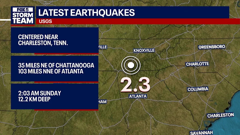
Overnight Earthquake
Another small earthquake – 2.3 magnitude – was reported just north of the Georgia/Tennessee line at 2:03 a.m. Sunday near Charleston, Tennessee, which is about 100 miles north-northeast of Atlanta.


Comments