Scattered thunderstorms have continued across the northern Plains this morning, part of a multiday pattern of rain driven by warm, moist air clashing with cooler air — a setup that creates unstable conditions with the potential for dangerous conditions.
As Tuesday, Aug. 5, progresses, additional storms are likely to begin this afternoon and continue into the evening, with the greatest risk concentrated in eastern South Dakota and southeastern North Dakota, where warm and cool air masses meet.
Some of these storms could strengthen into supercells — severe storms capable of producing large hail, damaging winds and possibly a tornado. The area with a slight risk (level 2 out of 5) stretches from Nebraska to Minot, North Dakota.
According to the National Weather Service in Aberdeen, hail could reach up to quarter-size (about 1 inch in diameter). The office also warns of the potential for damaging wind gusts, locally heavy rainfall and “a tornado or two,” especially in areas "west of the Coteau," where upper-level winds may create conditions more favorable for tornado development.
Areas along and east of Interstate 29 face a marginal risk (level 1 out of 5), but all severe weather hazards remain possible, according to the local National Weather Service office.
In North Dakota, the National Weather Service office in Bismarck warns of the potential for golf ball-sized hail, adding that a "tornado or two" are possible from the southern border of the state to Minot.
"There could be multiple rounds of storms throughout the day and night, so don’t let your guard down!" the office wrote.
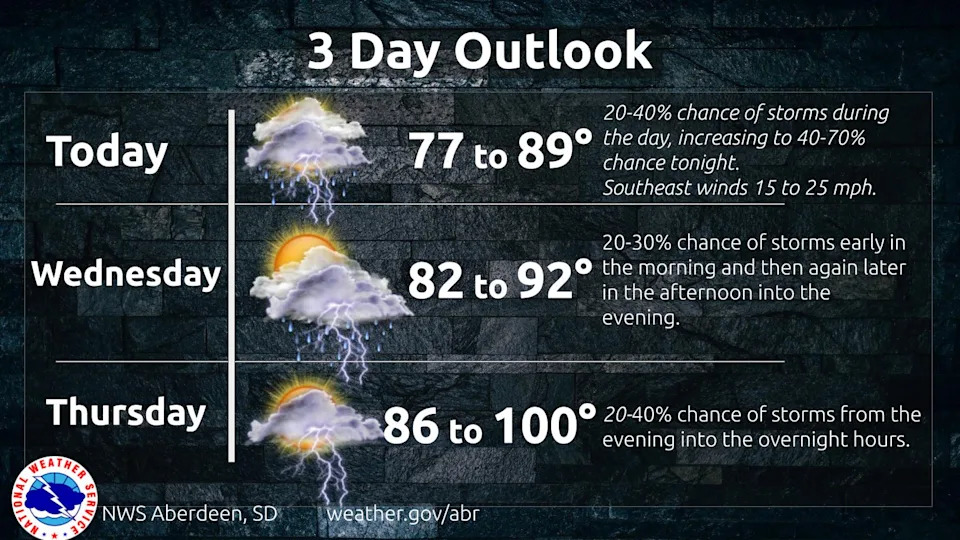
Storms possible throughout the week
A few strong storms are possible Wednesday and Thursday, Aug. 6-7, but the risk remains lower until a cold front moves through Friday, Aug. 8, increasing the chance for severe storms.
"Rinse and repeat," the National Weather Service office in Aberdeen wrote in its area forecast discussion. "The active pattern continues with showers and thunderstorms in the forecast into Saturday. Each day carries the risk for severe storms across portions of the area through Friday."
South Dakota weather watches and warnings
What’s the difference between a watch and a warning?
Understanding weather alerts can help you stay safe when severe weather strikes:
A watch means conditions are favorable for dangerous weather — such as severe thunderstorms, tornadoes or floods — to develop. It’s a heads-up that these events could happen, so you should be prepared and stay alert.
A warning means that severe weather — like a thunderstorm, tornado or flash flood — is occurring now or is imminent in your area. Warnings are issued based on radar data or confirmed reports and mean you should take immediate action to protect yourself.
This article originally appeared on Aberdeen News: Hail and tornadoes possible: See watches and warnings in South Dakota


Comments