Extreme heat watch for Twin Cities Sunday, severe storms possible in Minnesota originally appeared on Bring Me The News.
An extreme heat watch has been issued for the Twin Cities on Sunday, with severe storms also a possibility in Minnesota later in the day.
The heat wa goes into effect from 12 p.m. Sunday through Sunday evening and covers the area in and around the Twin Cities metro, as well as southern and southwestern Minnesota.
The National Weather Service is warning of "dangerously hot conditions," with air temperatures in the low 90s mixing with high humidity, potentially sending the heat index as high as 103F.
The service says that thermal energy will continue to build and "head eastward" on Sunday, placing more of Minnesota and Wisconsin "beneath the heat dome."
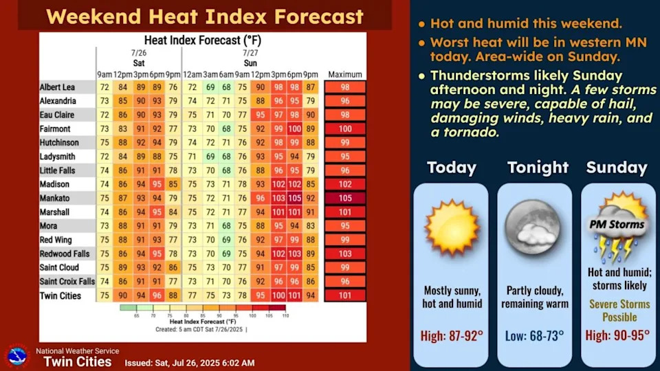
Later on Sunday, a troughing pattern from central Canada could bring instability to Minnesota, potentially resulting in severe storms on Sunday night into Monday morning.
There remains some uncertainty at this time, the NWS notes, namely regarding how far south the system will reach.
"But as of now, central up to northern Minnesota look to have better potential to see storms Sunday night into Monday," it says in its forecast discussion.
This story was originally reported by Bring Me The News on Jul 26, 2025, where it first appeared.


Comments