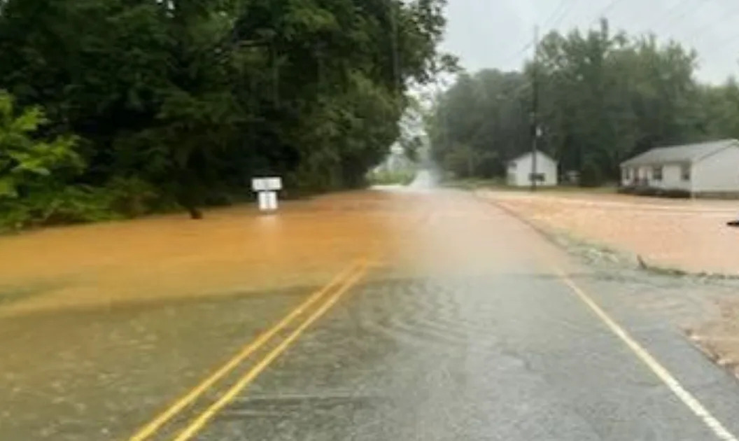
SAVANNAH, Ga. – A stalled frontal boundary draped across the Southeast, combined with developing areas of low pressure, is setting the stage for several more days of heavy rainfall from the Interstate 10 corridor northward through Georgia and the Carolinas.
The flooding is already responsible for the deaths of a man and a woman outside of Raleigh, North Carolina in nearby Nash County.
Authorities said the two were in their car when it was swept into a ravine. The two got themselves out onto the roof, but the rushing water swept them both away. Their bodies were found after a coordinated search.
"During these storms, it takes up just a little bit of debris in these pipes and things of nature that are going under the roads to turn a low area into a flooded area. I caution you when you're driving at night, when you go into these low-lying areas, that it is acceptable to flood you," Nash County Sheriff Keith Stone said.

According to the FOX Forecast Center, the potential for daily rounds of rain and thunderstorms will persist through the weekend, with some areas potentially receiving double-digit rainfall totals.
Flood Watches remain in effect for multiple counties across the region, particularly in areas that have already experienced significant rainfall over the past week.
These watches can be upgraded to Flood Warnings if storms repeatedly pass over the same locations, swamping already-saturated ground and overwhelming drainage systems.
Cities and communities in the greatest risk zone include Charleston and Myrtle Beach in South Carolina and Wilmington in North Carolina.
515-Mile ‘Megaflash’ From Texas To Missouri Confirmed As World’s Longest Lightning Bolt
All eyes are also on the western Atlantic Ocean, where a disorganized tropical disturbance is being monitored for potential development.
The National Hurricane Center currently gives the system just a low chance of forming into a tropical depression or tropical storm over the next few days.
However, the FOX Forecast Center stresses that the absence of a named storm does not change the threat, with significant chances of rainfall each and every day.
A Hurricane Hunter aircraft stands ready to investigate the system should the need arise.
As of midweek, rapid tropical development was not expected to occur, but forecasters remain watchful for any signs of organization as the system slowly drifts offshore.
In addition to the flooding concerns, isolated severe thunderstorms are possible through the remainder of the week.
Damaging wind gusts and frequent lightning may accompany stronger cells, and they’ll tend to move rather slowly.
Shipping Industry Reports More Than 500 Containers Lost At Sea During Past Year
Coastal impacts are also expected to increase, even in the absence of a named tropical system.
Rough surf and an elevated risk of rip currents will affect beaches from Florida to the Carolinas, posing a danger to swimmers.
A consequence of the persistent cloud cover and rain will be cooler daytime temperatures.
Several observation sites across the Southeast have reported near-record-low high temperatures, with typical readings well into 80s and 90s, during the final month of meteorological summer.
Original article source: 2 dead as heavy rainfall leads to flash flooding in Carolinas


Comments