A soggy spin of low pressure high in the atmosphere is promising showers and teasing thunderstorms for the southern tip of the Peninsula beginning Aug. 7, capping temperatures in the low 90s during what is climatologically the hottest days of the year in West Palm Beach.
Through Sunday, as much as 2 inches of rain is possible as measured at Palm Beach International Airport with amounts upwards of 3 inches potentially dousing the southern reaches of Miami-Dade County and into Collier and Lee Counties on the southwest coast.
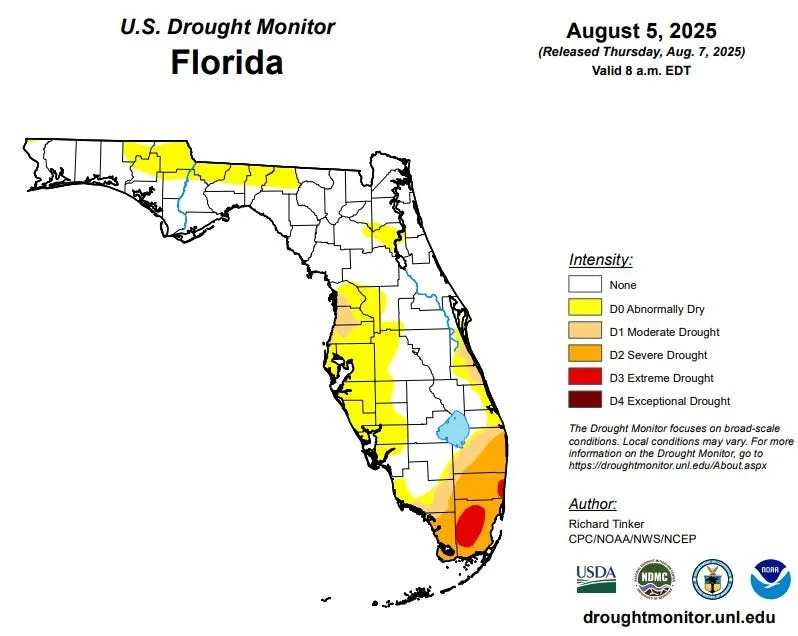
The showers aren’t expected to make a significant difference in the sucking drought that dogs southeast Florida, said Donal Harrigan, science and operations manager at the National Weather Service in Miami.
August has so far had an average temperature of 85.6 in West Palm Beach, which is 1 degree above normal and ranks the month as the 6th warmest on record.
By mid-month, temperatures statewide as measured on a long-term scale will begin a sluggish decline with tiny dips in the mercury that may go largely unnoticed until cool fronts begin drooping south in late September and October.
Florida climatologist David Zierden said in a 2024 interview that the hottest day of the year only varies by two or three weeks across the state and can depend on what data and time period is used to measure the temperature.
More: Climate change triggers new Florida heat warning chart that alerts when it could be deadly outside
In West Palm Beach, the warmest days are Aug. 8 to Aug. 11 when the average normal daytime high tops out at 91.1 degrees, according to an analysis by the National Centers for Environmental Information (NCEI) of the years 2006-2020.
The highest daily temperature in West Palm Beach this summer was 96 on both Aug. 1 and Aug. 4. That’s six degrees above normal but missed the record of 97 set on both days in 1970 and 1989, respectively.
In Jacksonville Beach, the daytime high lingers stubbornly at 89.5 through Aug. 14, while Naples suffers with a high of 92.1 through Aug. 22. Tallahassee’s top average temp of 92.3 stretches painfully from late July to Aug. 6 before it begins to tick down.
Although summer’s astronomical beginning is June 21 when solar radiation reaching Earth is at its highest, temperatures continue to rise for weeks after because the daytime sunshine and heat is greater than overnight cooldowns.
A small reprieve in temperatures with the pending forecast for rainfall won’t last long, Harrigan said.
“There will be cooler actual temperatures but we look to remain above average on the back side of the low pressure system,” he said.
And, the humidity will keep “feels like” temperatures in the range of 105 to 108 degrees through Sunday.
Through the weekend, meteorologists are warning of the potential for localized flooding, particularly if showers stall over an area. Some areas may welcome a soaking.
About 78% of Palm Beach County is suffering moderate to severe drought, which are levels one and two on a four-tier drought scale. Miami-Dade and Broward counties also have areas with the level three category of extreme drought, according to the U.S. Drought Monitor report released Aug. 7.
“The probability of putting a dent in the drought will be the highest in southern Miami-Dade County where the sea breeze zips up from the bottom but I doubt we’ll cut too much into it, maybe a category at best across Palm Beach County,” Harrigan said.
More: 126 days with temps that feel like 105 degrees? Florida's heading that way
Nearly three months into the rainy season, which officially ends Oct. 15, rainfall in West Palm Beach is down 13.4 inches for the year. Fort Lauderdale has a deficit of 15 inches and Miami is down nearly 5 inches.
Sammy Hadi, a meteorologist with the Miami NWS office, said a strong Bermuda High is to blame for the parched southeast coast. Its persistent easterly winds have caused afternoon sea breezes to push deeper into the center of the state keeping daily showers away from the coast.
At the same time, he said the easterly flow has resulted in fewer heat advisory days compared to last year. Through Aug. 6, Palm Beach County has had nine days where the high humidity combined with high temperatures warranted an advisory.
In 2024 there were 20 days with heat advisories through Aug. 6, caused, in part, by a weaker Bermuda High.
“The pattern in 2024 featured warm southwesterly/southerly winds heated by the shallow and hot nearshore Gulf waters,” Hadi said.
Kimberly Miller is a journalist for The Palm Beach Post, part of the USA Today Network of Florida. She covers real estate, weather, and the environment. Subscribe to The Dirt for a weekly real estate roundup. If you have news tips, please send them to [email protected]. Help support our local journalism, subscribe today.
This article originally appeared on Palm Beach Post: Hottest days of the year in South Florida happen in early August


Comments