Do you know where your umbrella is?
If it's been awhile since you've had to use it, better find it.
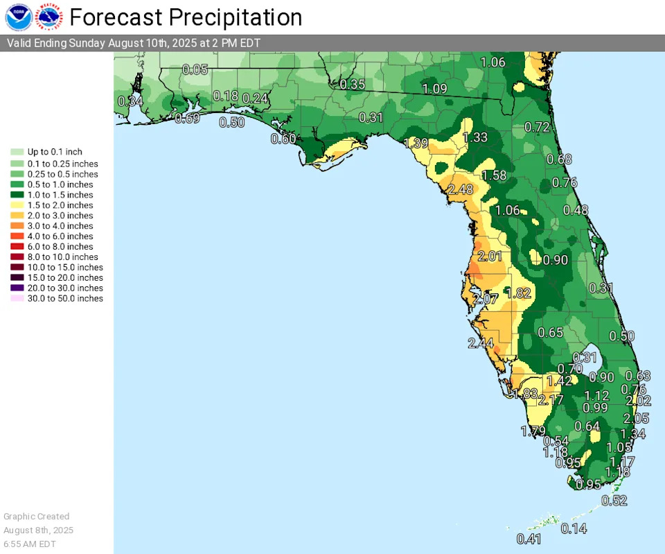
Rain is expected through the weekend across much of Florida, with some areas possibly looking at up to 8 inches in isolated areas, according to the National Weather Service.
➤ Weather alerts via text: Sign up to get updates about current storms and weather events by location
The good news is that while there are some systems in the tropics being watched by the National Hurricane Center, no threats to Florida are expected over the next several days.
Weather watches and warnings issued across the U.S.
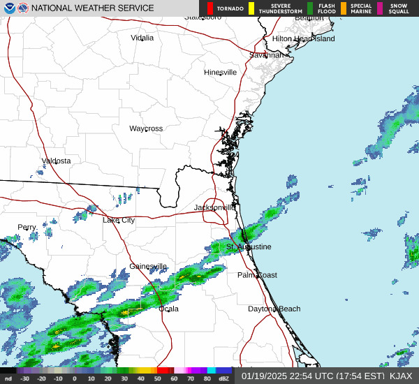
National weather radar
Expect plenty of rain across Florida in your weekend forecast
Pensacola, western Panhandle: Best chances for rain remain along and south of the coast into the weekend, then move more inland mainly over eastern portions of the forecast area over the weekend, according to the National Weather Service Mobile.
Tallahassee, central Panhandle: Today will feature a few more afternoon/evening thunderstorms, compared with Thursday, especially over the Big Bend. A quick inch or two of rain is possible, along with frequent lightning Spoitty locations will get a quick 1-2 inches of rain, according to the National Weather Service Tallahassee.
Jacksonville, Northeast Florida: Heavy rainfall and thunderstorm threat continues today for Northeast Florida as a front remains stalled across the area. Five-day forecast predicting 2-5 inches of rain, with high-end total of 6-8 inches, according to the National Weather Service Jacksonville. A localized flash flood risk continues through the weekend.
East Coast, central Florida: Warm and humid today. Numerous storms forecast this afternoon/evening (coastal: 50-60% inland: 70-80%). Main hazards will be lightning, gusty winds, and locally heavy rainfall of 1-3 inches, which could lead to minor flooding. There is a high risk of rip currents at area beaches, according to the National Weather Service Melbourne.
South Florida: Storms will again focus over interior and western areas of South Florida. A few storms may become strong this afternoon, capable of producing damaging winds and heavy downpours. Excessive rainfall could lead to localized urban and poor drainage flooding, according to the National Weather Service Miami.
West coast, Southwest Florida: Widespread showers and storms are expected again Aug. 8 across west central and southwest Florida, with the highest rain chances in the afternoon and early evening hours. This heavy rainfall brings a marginal chance of flooding occurring in areas with the heaviest rain, according to the National Weather Service Tampa Bay.
Weather alerts issued in Florida
Weather radar, weekend forecast for Pensacola, Florida
Friday: A 20 percent chance of showers and thunderstorms after 4 p.m. Mostly sunny, with a high near 88. East wind around 10 mph.
Saturday: Showers and thunderstorms likely, mainly after 1 p.m. Partly sunny, with a high near 88. East wind around 10 mph. Chance of precipitation is 70%. New rainfall amounts between a tenth and quarter of an inch, except higher amounts possible in thunderstorms.
Sunday: Showers likely and possibly a thunderstorm before 1 p.m., then showers and thunderstorms between 1 p.m. and 4 p.m., then showers and possibly a thunderstorm after 4 p.m. High near 87. East wind around 10 mph. Chance of precipitation is 80%.
Follow National Weather Service Mobile on X, formerly known as Twitter
Weather radar, weekend forecast for Tallahassee, Florida
Friday: A 40 percent chance of showers and thunderstorms, mainly after 2 p.m. Partly sunny, with a high near 89. Northeast wind around 5 mph.
Saturday: A chance of showers, then showers and thunderstorms after 11 a.m. High near 87. East wind around 5 mph. Chance of precipitation is 90%. New rainfall amounts between a tenth and quarter of an inch, except higher amounts possible in thunderstorms.
Sunday: Showers and thunderstorms, mainly between 2 p.m. and 5 p.m., then showers and possibly a thunderstorm after 5 p.m. High near 86. East southeast wind around 5 mph. Chance of precipitation is 90%.
Follow the National Weather Service Tallahassee on X, formerly known as Twitter
Weather radar, weekend forecast for Jacksonville, Florida
Friday: Showers and thunderstorms, mainly after 1 p.m. High near 88. East wind 10 to 14 mph, with gusts as high as 21 mph. Chance of precipitation is 80%. New rainfall amounts between a tenth and quarter of an inch, except higher amounts possible in thunderstorms.
Saturday: Showers and possibly a thunderstorm before 2 p.m., then showers and thunderstorms after 2 p.m. High near 86. East wind 6 to 11 mph, with gusts as high as 17 mph. Chance of precipitation is 90%. New rainfall amounts between a quarter and half of an inch possible.
Sunday: Showers and thunderstorms, mainly before 5 p.m., then showers and possibly a thunderstorm after 5 p.m. High near 87. East wind 5 to 10 mph, with gusts as high as 16 mph. Chance of precipitation is 90%.
Follow the National Weather Service Jacksonville on X, formerly known as Twitter
Weather radar, weekend forecast for Daytona Beach, Florida
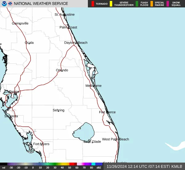
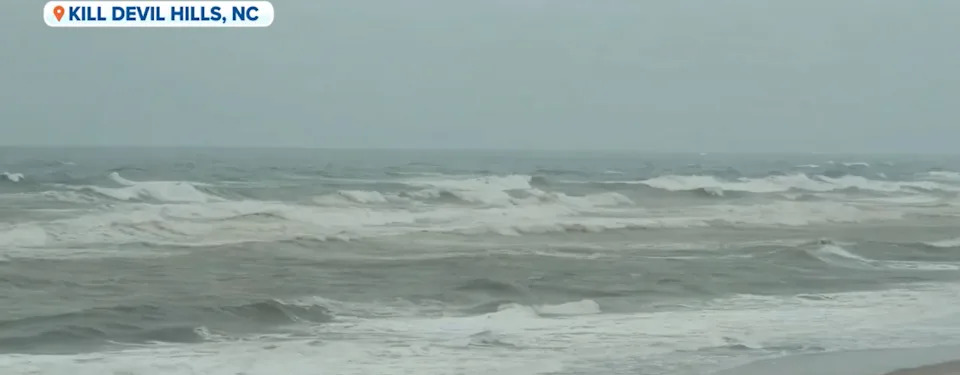
Dangerous rip currents are expected at all central Florida beaches through 4 a.m. Aug. 9.
Friday: Showers and thunderstorms likely, mainly between 1 p.m. and 3 p.m. Partly sunny, with a high near 88. East wind 5 to 10 mph. Chance of precipitation is 60%. New rainfall amounts of less than a tenth of an inch, except higher amounts possible in thunderstorms.
Saturday: Showers and possibly a thunderstorm, mainly before 2 p.m., then showers and thunderstorms after 2 p.m. High near 87. Southeast wind 5 to 10 mph. Chance of precipitation is 90%. New rainfall amounts between a tenth and quarter of an inch, except higher amounts possible in thunderstorms.
Sunday: Showers and thunderstorms, mainly before 5 p.m., then showers and possibly a thunderstorm after 5 p.m. High near 88. Southeast wind 5 to 10 mph. Chance of precipitation is 80%.
Follow the National Weather Service Melbourne on X, formerly known as Twitter
Weather radar, weekend forecast for Melbourne, Florida
Dangerous rip currents are expected at all central Florida beaches through 4 a.m. Aug. 9.
Friday: A 50 percent chance of showers and thunderstorms. Partly sunny, with a high near 90. Heat index values as high as 102. East southeast wind 5 to 10 mph. New rainfall amounts between a quarter and half of an inch possible.
Saturday: Showers likely and possibly a thunderstorm before 2 p.m., then showers and thunderstorms between 2 p.m. and 5 p.m., then showers and possibly a thunderstorm after 5 p.m. High near 90. Southeast wind 5 to 15 mph. Chance of precipitation is 80%. New rainfall amounts between a tenth and quarter of an inch, except higher amounts possible in thunderstorms.
Sunday: A chance of showers and thunderstorms before 8 a.m., then showers likely and possibly a thunderstorm between 8 a.m. and 2 p.m., then showers and thunderstorms likely after 2 p.m. Partly sunny, with a high near 90. Southeast wind 5 to 10 mph. Chance of precipitation is 70%.
Follow the National Weather Service Melbourne on X, formerly known as Twitter
Weather radar, weekend forecast for Port St. Lucie, Florida
Dangerous rip currents are expected at all central Florida beaches through 4 a.m. Aug. 9.
Friday: Showers and thunderstorms likely, mainly after 2 p.m. Partly sunny, with a high near 91. East southeast wind 5 to 10 mph. Chance of precipitation is 60%. New rainfall amounts of less than a tenth of an inch, except higher amounts possible in thunderstorms.
Saturday: Showers and possibly a thunderstorm before 2 p.m., then showers and thunderstorms between 2 p.m. and 5 p.m., then showers and possibly a thunderstorm after 5 p.m. High near 90. Light south southeast wind becoming southeast 5 to 10 mph in the morning. Chance of precipitation is 80%. New rainfall amounts between a tenth and quarter of an inch, except higher amounts possible in thunderstorms.
Sunday: A chance of showers and thunderstorms before 8 a.m., then showers likely and possibly a thunderstorm between 8 a.m. and 2 p.m., then showers and thunderstorms likely after 2 p.m. Mostly sunny, with a high near 91. Southeast wind 5 to 10 mph. Chance of precipitation is 70%.
Follow the National Weather Service Melbourne on X, formerly known as Twitter
Weather radar, weekend forecast for West Palm Beach, Florida
Friday: Showers and thunderstorms. High near 85. Southeast wind 9 to 13 mph. Chance of precipitation is 80%. New rainfall amounts between a tenth and quarter of an inch, except higher amounts possible in thunderstorms.
Saturday: Showers and possibly a thunderstorm, mainly before 2 p.m., then showers and thunderstorms after 2 p.m. High near 85. Southeast wind 10 to 14 mph. Chance of precipitation is 80%. New rainfall amounts between a quarter and half of an inch possible.
Sunday: Showers and thunderstorms, mainly before 5 p.m., then showers and possibly a thunderstorm after 5 p.m. High near 87. Southeast wind 10 to 13 mph. Chance of precipitation is 80%.
Follow the National Weather Service Miami on X, formerly known as Twitter
Weather radar, weekend forecast for Miami, Florida
Friday: Showers and possibly a thunderstorm before noon, then showers and thunderstorms likely, mainly after 2 p.m. Some of the storms could produce heavy rainfall. High near 88. Heat index values as high as 101. East wind around 10 mph. Chance of precipitation is 80%. New rainfall amounts between a half and three quarters of an inch possible.
Saturday: Showers and thunderstorms likely before 8 a.m., then showers and possibly a thunderstorm between 8 a.m. and 2 p.m., then showers and thunderstorms likely after 2 p.m. High near 87. Heat index values as high as 101. Southeast wind around 11 mph. Chance of precipitation is 80%. New rainfall amounts between a tenth and quarter of an inch, except higher amounts possible in thunderstorms.
Sunday: A chance of showers and thunderstorms before 8 a.m., then showers and possibly a thunderstorm between 8 a.m. and 2 p.m., then showers and thunderstorms likely after 2 p.m. High near 88. Southeast wind around 10 mph. Chance of precipitation is 80%.
Follow the National Weather Service Miami on X, formerly known as Twitter
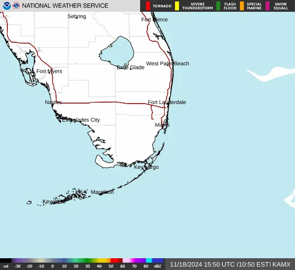
Weather radar, weekend forecast for Naples, Florida
Friday: Showers and thunderstorms. High near 89. Heat index values as high as 100. South wind 7 to 10 mph. Chance of precipitation is 80%. New rainfall amounts between a tenth and quarter of an inch, except higher amounts possible in thunderstorms.
Saturday: Showers and possibly a thunderstorm before 2 p.m., then showers and thunderstorms after 2 p.m. High near 91. Heat index values as high as 105. South wind 6 to 10 mph. Chance of precipitation is 90%. New rainfall amounts between a quarter and half of an inch possible.
Sunday: A chance of showers and thunderstorms before 8 a.m., then showers likely and possibly a thunderstorm between 8 a.m. and 2 p.m., then showers and thunderstorms after 2 p.m. High near 90. Southeast wind 6 to 10 mph. Chance of precipitation is 90%.
Follow the National Weather Service Miami on X, formerly known as Twitter
Weather radar, weekend forecast for Fort Myers, Florida
Friday: Scattered showers and thunderstorms, then showers and possibly a thunderstorm after 2 p.m. High near 91. Southeast wind around 7 mph. Chance of precipitation is 80%. New rainfall amounts between a quarter and half of an inch possible.
Saturday: Scattered showers and thunderstorms, then showers and possibly a thunderstorm after 8 a.m. High near 91. South southeast wind around 7 mph. Chance of precipitation is 80%. New rainfall amounts between three quarters and one inch possible.
Sunday: Scattered showers and thunderstorms, then showers and possibly a thunderstorm after 8 a.m. High near 91. East southeast wind around 7 mph. Chance of precipitation is 80%
Follow the National Weather Service Tampa Bay on X, formerly known as Twitter
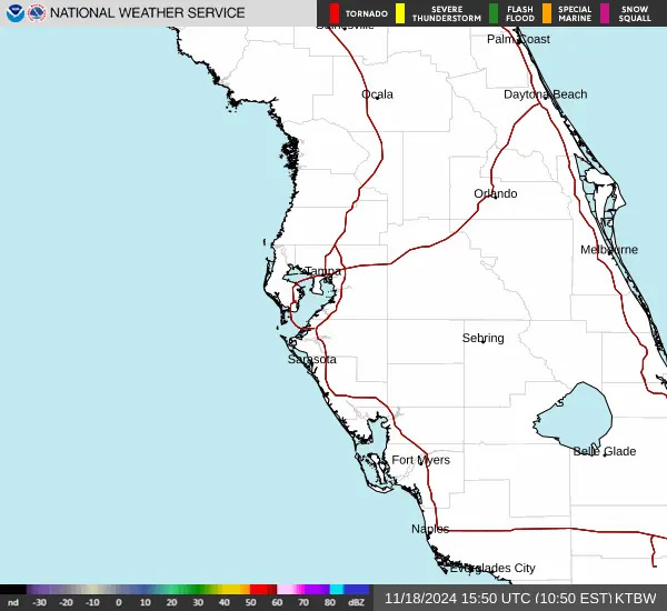
Weather radar, weekend forecast for Sarasota, Florida
Friday: Scattered showers and thunderstorms, then showers and possibly a thunderstorm after 3 p.m. High near 90. East wind around 9 mph becoming south southwest in the afternoon. Chance of precipitation is 80%. New rainfall amounts between a half and three quarters of an inch possible.
Saturday: Scattered showers and thunderstorms, then showers and possibly a thunderstorm after 8 a.m. High near 89. East southeast wind around 10 mph. Chance of precipitation is 80%. New rainfall amounts between a quarter and half of an inch possible.
Sunday: Scattered showers and thunderstorms, then showers and possibly a thunderstorm after 8 a.m. High near 89. South wind around 10 mph. Chance of precipitation is 80%.
Follow the National Weather Service Tampa Bay on X, formerly known as Twitter
Weather radar, weekend forecast for Orlando, Florida
Friday: Showers and thunderstorms likely, then showers and possibly a thunderstorm after 5 p.m. High near 91. East wind around 5 mph. Chance of precipitation is 80%. New rainfall amounts between a quarter and half of an inch possible.
Saturday: A chance of showers, then showers and thunderstorms after 11 a.m. High near 91. Southeast wind 5 to 10 mph. Chance of precipitation is 90%. New rainfall amounts between a tenth and quarter of an inch, except higher amounts possible in thunderstorms.
Sunday: A chance of showers, then showers and thunderstorms after 11 a.m. High near 91. Southeast wind 5 to 10 mph. Chance of precipitation is 80%.
Follow the National Weather Service Melbourne on X, formerly known as Twitter
Stay informed. Get weather alerts via text
What's next?
We will continue to update our weather coverage as conditions warrant. Download your local site's app to ensure you're always connected to the news. And look for our special subscription offers here.
This article originally appeared on Florida Times-Union: Florida weekend rain forecast: NWS radar, storm outlook


Comments