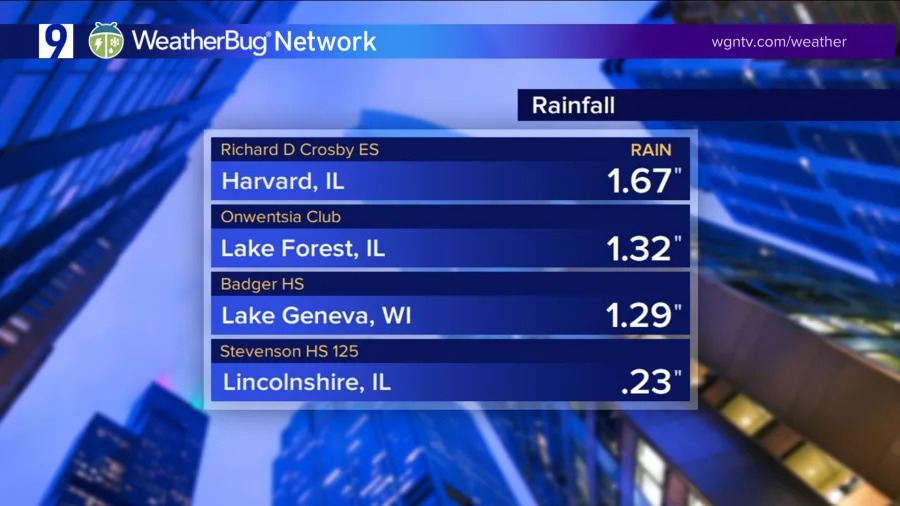
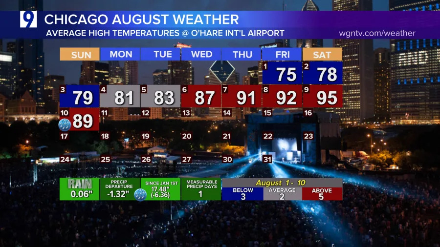
Finally, some needed rainfall in the month of August.
Not much, but we did get some raindrops in the city. It took ten days to make it happen. And while we saw some significant rainfall for some areas in northern Chicagoland, we were only about 87 miles from a much different weekend.
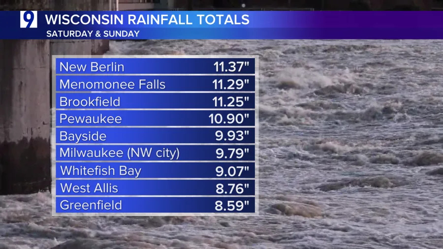
Our neighbors to the north in Wisconsin saw some epic amounts of rain this weekend. Two-day rain totals in some parts of southeastern Wisconsin were more than double what we typically see in August for the whole 31-day period.
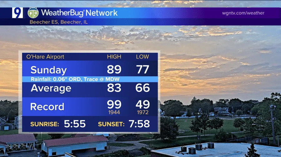
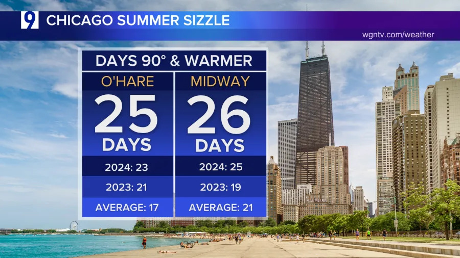
The culprit a stalled boundary between the warm and dry weather to the north and west of us and the muggy and hot weather we’ve been sweating under this weekend. An average August sees about 4 (ORD) or 5 (MDW) days of 90 or warmer, depending which airport we’re talking about. So far, we’ve seen about that many around here– with 2/3rds of the month left to go.
On Saturday we racked up yet another of our hottest days of the year– which have all topped out at 95 degrees this summer. Due to the cloud cover today, O’Hare didn’t quite get to 90– but Midway Int’l got into the 90s.
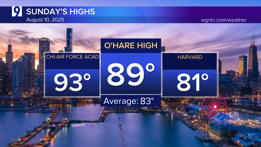
Warmest spot around town for Sunday was at the Air Force Academy High School just south of Sox Park at 93 degrees today. Coolest was areas under the clouds in McHenry County near Harvard.
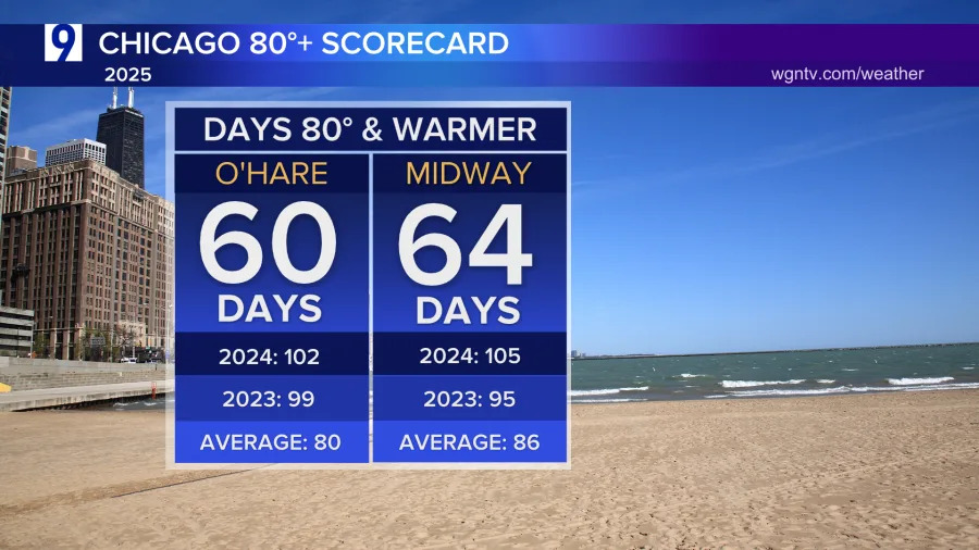
We will be cooling back to the seasonal 80s, but we’ll be at or above 80 for about all of the week ahead. The tally of days of 80 or warmer are slowly creeping up into the 60s.
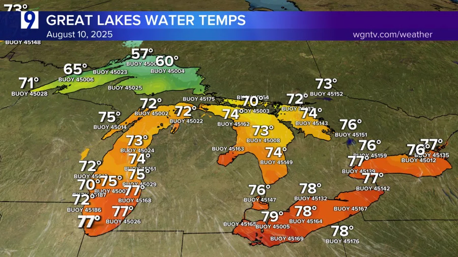
Water temps in the Great Lakes have reached what’s likely close to peak heat along the Chicago shore. Earlier this week the water along the lakefront hit 77 degrees. That’s one-degree warmer than all of last year.
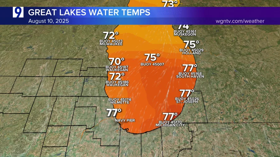
That will have a big impact on our fall weather. Water hangs onto heat much more effectively than air does– so the lake will stay warm even when the air starts to get cold in late fall. That combination can make for some big lake effect snow later this year– especially for northwest Indiana and western lower Michigan.
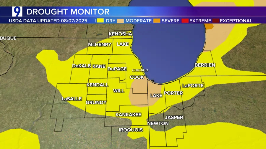
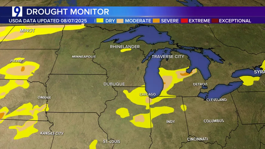
Due to some late July rainfall, we’ve seen some big improvemnts locally in the weekly Drought Monitor released by the USDA on Thursdays. Only a few spots are considered to be in ‘moderate’ amounts of drought and the rest of us are in areas considered only ‘unusually dry’.
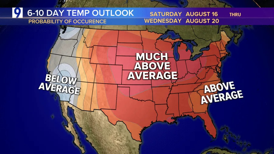
We’re likely still not done with the warmer than average temperatures and wildfire smoke– we’ve been plagued by both this entire summer in Chicagoland. The 6-10 day outlook calls for much above average for this time of year– which usually means more 90s on the way. For us, just not until next weekend. So, try and enjoy the middle of the week break from heat & humidity if you’re able to.
Things to mark on your calendar: the Perseid meteor shower is active now and peaks on this year on Tuesday the 12th. You can actually catch those “shooting stars” any night between now and August 24th– but you’ll see the most on the 12th and 13th. The nearly full moon can diminish how many meteors you can see– so have it blocked by a building or tree. Best viewing for the Perseid Meteor showers is to get away from city lights and look straight up around midnight. Enjoy!
Copyright 2025 Nexstar Media, Inc. All rights reserved. This material may not be published, broadcast, rewritten, or redistributed.
For the latest news, weather, sports, and streaming video, head to WGN-TV.


Comments