Will the first hurricane of the 2025 Atlantic hurricane season emerge this week?
Invest 97L, a developing system in the eastern Atlantic, could strengthen into a tropical depression or tropical storm as early as this morning, Aug. 11, according to the National Weather Center.
AccuWeather forecasters predict the system could strengthen into a hurricane by Thursday, Aug. 14, and possibly even into a major hurricane — of Category 3 or greater — by Aug. 16. Historically, the first hurricane of the Atlantic season forms Aug. 11.
➤ Weather alerts via text: Sign up to get updates about current storms and weather events by location
More: NWS hiring for 450 jobs after DOGE cuts as wildfire, hurricane dangers peak
Will Invest 97L form this week?
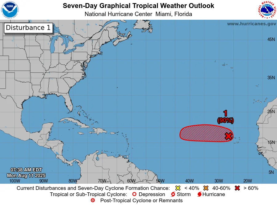
Invest 97L began in the far eastern Atlantic near Africa and is now moving west-northwest to northwest across the central Atlantic.
As of the latest advisory on Aug. 11, Invest 97L has a high chance — 90% — chance of strengthening in the next seven days and is expected to become a tropical depression or storm as early as Monday morning, according to the National Hurricane Center.
NOAA hurricane tracker: See spaghetti models for Invest 97L
Special note about spaghetti models: Illustrations include an array of forecast tools and models, and not all are created equal. The hurricane center uses only the top four or five highest performing models to help make its forecasts.
Will Invest 97L impact Texas?
It’s too early to tell if Invest 97L will affect the U.S. directly, but it's unlikely to continue its path to Texas.
Current spaghetti models mostly show the system drifting west-northwestward, well offshore the U.S. East Coast, moving into the open Atlantic near the Sargasso Sea, northeast of the Turks and Caicos. However, tropical systems can change course quickly, so forecasters are watching closely.
Even if the storm curves north and stays away from the U.S., Invest 97L could still bring increased rough surf and rip currents along the East Coast next weekend into early next week but poses little threat to Gulf Coast states.
Texas weather radar
Texas weather watches and warnings
What’s the difference between a watch and a warning?
Understanding weather alerts can help you stay safe when severe weather strikes:
A warning means that severe weather — like a thunderstorm, tornado or flash flood — is occurring now or is imminent in your area. Warnings are issued based on radar data or confirmed reports and mean you should take immediate action to protect yourself.
A watch means conditions are favorable for dangerous weather — such as severe thunderstorms, tornadoes or floods — to develop. It’s a heads-up that these events could happen, so you should be prepared and stay alert.
What is an invest?
Short for investigation, the National Hurricane Center uses the term invest for areas of low pressure it is monitoring for potential development into a tropical depression or storm.
Invests are not tropical depressions or tropical storms. They're usually clusters of showers and thunderstorms, and just because they've been designated as an invest does not guarantee they'll strengthen into a tropical storm or hurricane.
Invests run from 90 to 99, followed by a letter: L for the Atlantic basin and E for those in the eastern Pacific. After 99, it starts over again and the next invest would be 90.
Once something has been designated as an invest, specialized data sets and computer models can begin, including scheduling Hurricane Hunter aircraft missions and running spaghetti models.
What tropical waves, disturbances are in Atlantic basin now? How likely are they to strengthen?
Invest 97L: Shower and thunderstorm activity has persisted and continues to show signs of organization with a well-defined area of low pressure located just to the west of the Cabo Verde Islands.
If these structural trends continue, the system is likely to become a tropical depression or storm, possibly as soon as Aug. 11.
Locally heavy rainfall and gusty winds are expected to continue today across portions of the Cabo Verde Islands, and interests there should monitor the progress of this system.
Regardless of development over the next couple of days, the system is expected to continue moving westward to west-northwestward at 15 to 20 mph across the eastern and central tropical Atlantic.
Formation chance through 48 hours: high, 90%.
Formation chance through seven days: high, 90%.
Invest 96L: A weak trough of low pressure located over the central Atlantic is only producing limited shower and thunderstorm activity. Significant development of this system is becoming unlikely over the next few days as the system drifts generally northward, remaining over the central Atlantic.
Formation chance through 48 hours: low, 10%.
Formation chance through seven days: low, 10%.
Area of low pressure: A non-tropical area of low pressure is currently located a few hundred miles to the south-southeast of Nova Scotia, Canada. While current shower and thunderstorm activity with the system is limited, this system is drifting over the warm waters of the Gulf Stream where some tropical or subtropical development could occur over the next day or two. By the middle of this week, the system is expected to move northward over cooler waters, ending its changes for further tropical development.
When is the Atlantic hurricane season?
The Atlantic hurricane season runs from June 1 through Nov. 30.
Ninety-seven percent of tropical cyclone activity occurs during this time period, NOAA said.
The Atlantic basin includes the northern Atlantic Ocean, Caribbean Sea and Gulf of America, as the Gulf of Mexico is now known in the U.S. per an order from President Trump. NOAA and the National Hurricane Center are now using Gulf of America on its maps and in its advisories.
Stay informed. Get weather alerts via text
Brandi D. Addison covers weather across the United States as the Weather Connect Reporter for the USA TODAY Network. She can be reached at [email protected].
This article originally appeared on Corpus Christi Caller Times: Invest 97L may become Hurricane Erin. See path, spaghetti models


Comments