Tropical Storm Erin is expected to begin strengthening soon and is likely to become a hurricane in the next 48 hours, according to the latest advisory Aug. 12 from the National Hurricane Center.
Erin is racing westward across the Atlantic at 22 mph and is forecast to become the season’s first hurricane — and a major one, meaning Category 3 or higher with sustained winds of at least 111 mph.
While the 2025 season may feel slow compared with 2024 — when Hurricane Beryl became the earliest Category 5 storms on record before making its final landfall in Matagorda, Texas — Erin is actually right on schedule when it comes to hurricane status.
The first hurricane usually develops around Aug. 11, the first major hurricane around Sept. 1, and the fifth named storm around Aug. 22, according to AccuWeather.
More: What are the odds a hurricane impacts North Carolina in 2025? See state-by-state risk
The storm’s approach comes as forecasters say hurricane season is entering its most active stretch. Colorado State University meteorologists are holding to their July outlook for a slightly above-average season: 16 named storms, including eight hurricanes, three of them major. Four storms have already formed, compared with an average of 14 named storms and seven hurricanes.
For North Carolina, it’s been a quiet start. Last September, the state was tracking Tropical Storm Helene, which struck Florida’s Big Bend before battering the Appalachians, causing flash floods, landslides and killing hundreds.
So far, no storms have directly affected the state, but Colorado State researchers say North Carolina has one of the highest odds of seeing impacts from a hurricane or named storm this season — second only to Florida.
➤ Weather alerts via text: Sign up to get updates about current storms and weather events by location
Will Tropical Storm Erin impact North Carolina?
Special note on the NHC cone: The forecast track shows the most likely path of the center of the storm. It does not illustrate the full width of the storm or its impacts, and the center of the storm is likely to travel outside the cone up to 33% of the time.
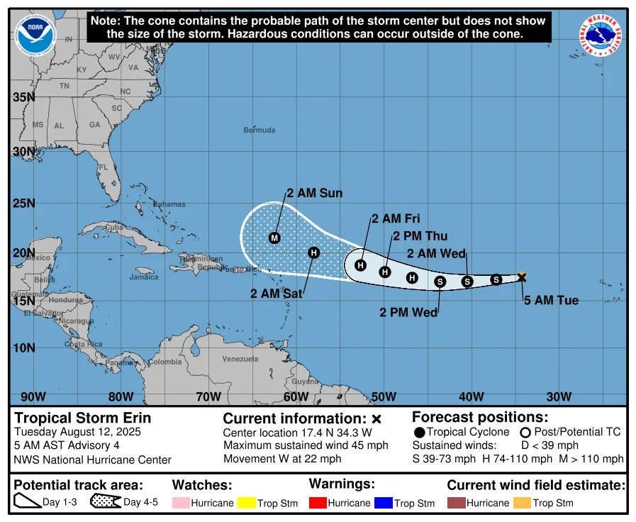
It's too early at this time to determine whether Erin will have any impacts on North Carolina or reach the United States at all.
Still, even if Erin does avoid landfall on the U.S., "there will be a significant increase in seas, surf and rip currents along the East Coast beaches next weekend into the following week," said AccuWeather Senior Meteorologist Chad Merrill.
Regardless of formation, North Carolina is expected to receive between 3 to 7 inches of precipitation over the next seven days along the coast, according to the National Weather Prediction Center.
Here's the latest update on Tropical Storm Erin.
Location: 690 miles west of the Cabo Verde Islands; 1,890 miles east of the northern Leeward Islands
Maximum sustained winds: 45 mph
Movement: west at 22 mph
Pressure: 1,004 mb
Where is Tropical Storm Erin headed? See projected path
Tropical Storm Erin spaghetti models
Special note about spaghetti models: Illustrations include an array of forecast tools and models, and not all are created equal. The hurricane center uses only the top four or five highest performing models to help make its forecasts.
When is the Atlantic hurricane season?
The Atlantic hurricane season runs from June 1 through Nov. 30.
Ninety-seven percent of tropical cyclone activity occurs during this time period, NOAA said. The season peaks in August and September.
The Atlantic basin includes the northern Atlantic Ocean, Caribbean Sea and Gulf of America, as the Gulf of Mexico is now known in the U.S. per an order from President Trump. NOAA and the National Hurricane Center are now using Gulf of America on its maps and in its advisories.
North Carolina weather radar
North Carolina weather watches and warnings
Stay informed. Get weather alerts via text
Brandi D. Addison covers weather across the United States as the Weather Connect Reporter for the USA TODAY Network. She can be reached at [email protected].
This article originally appeared on Asheville Citizen Times: Tropical Storm Erin tracker, see spaghetti models, projected path


Comments