The name of our most recent tropical storm, Erin, has a history that dates back to the 1980s that includes an Oklahoma tropical storm and September 11th.
(The Latest: Erin Forecast To Become A Major Hurricane)
This year’s Erin is the name’s sixth and almost seventh iteration. Let’s take a look back through Erin’s history:
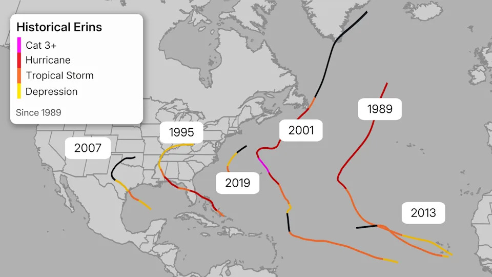
2019’s Carolina Fish: The most recent Erin in the history books drifted off the coast of North and South Carolina for a few days in late August.
2013: 2025’s Near Clone: This version was a short-lived Cabo Verde tropical storm, but unlike 2025’s, this one only lasted a couple of days due to increasing wind shear. The tracks of these two Erins didn’t repeat, but they did rhyme.
(MORE: For even more granular weather data tracking in your area, view your 15-minute details forecast in our Premium Pro experience.)
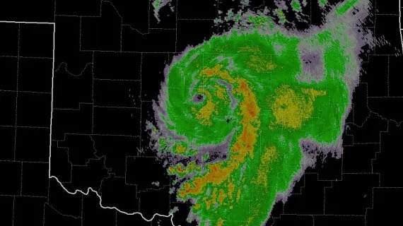
2007’s Eye In Oklahoma…?: This is by far the most notable of the Erins, and it opened up a discussion about where tropical storms are possible. Initially, this was a fairly typical tropical storm in the Gulf for mid-August. It was expected to be a rainmaker for Texas and then dissipate as a tropical cyclone over land.
Erin had different plans.
Three days after landfall, Erin developed an eye-like structure over central Oklahoma, and maximum sustained winds grew to 60 mph. Gusts up to 80 mph were recorded. Despite its appearance and impacts, the National Hurricane Center deemed this rebirth as non-tropical due to some support that Erin received from an upper-level dip in the jet stream.
This storm caused 16 fatalities – nine in Texas, six in Oklahoma and one in Missouri. Many of the deaths were due to inland flooding that people drove into with automobiles. Several homes were also flooded in the Oklahoma City metro area.
(Further beef up your forecast with our detailed, hour-by-hour breakdown for the next 8 days – only available on our Premium Pro experience.)
2001’s Two-Part Erin May Have Affected 9/11: That hurricane was a Cabo Verde Hurricane that swept through the western Atlantic during the first half of September 2001. Ahead of the attacks, a cold front was about to steer Hurricane Erin away from the Northeast.
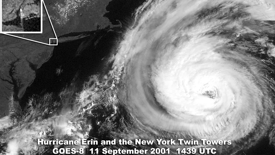
The boundary and Erin’s drying continental winds led to picturesque weather conditions along the Eastern Seaboard during the morning of September 11th.
(MORE: What If Hurricane Erin Had Hit the East Coast on 9/11?)
1995 Brought An Early “E” Storm: Erin developed in the Bahamas in late July. The storm then crossed central Florida, before it moved through the lower-Mississippi Valley. Prior to Erin becoming a hurricane, it was responsible for sinking the Club Royale ship in the Bahamas, which killed three crew members. Three additional people drowned off Florida’s coast.
The Earliest Erin Was Afraid Of Land: The name was first used in the Atlantic in 1989, but its impact after leaving Africa was minimal. It got going in the Cabo Verde Islands, then gained latitude for more than a week in the open Atlantic.
The Early Years: New lists of names were adopted in 1979 when male names were added to the rotating list of female names. Erin was added to one of those lists in that year, but it was set to appear for the first time in 1983. That hurricane season was very quiet and only made it to the “D” storm. Erin was never used until 6 years later.
Jonathan Belles has been a digital meteorologist for weather.com for 9 years and also assists in the production of videos for The Weather Channel en español. His favorite weather is tropical weather, but also enjoys covering high-impact weather and news stories and winter storms. He's a two-time graduate of Florida State University and a proud graduate of St. Petersburg College.


Comments