At least three people have died after heavy rain and flash flooding lashed Chattanooga, Tennessee, overnight Tuesday and shut down interstates, stranded cars and prompted swift water rescues.
A family of two adults and one child died after a tree fell on their car in East Ridge Wednesday morning, the Hamilton County Office of Emergency Management and Homeland Security.
At least one man is also missing in the floodwaters, authorities said. First responders saw the man swept away by floodwaters and attempted to look for him by swift water boat, but were unable to find him. The search for that man is a “top priority this morning at first light,” the Office of Emergency Management said.
Chattanooga Airport recorded 6.42 inches of rain on Tuesday, marking the second wettest day in the city’s history since records began in 1879, the National Weather Service Office in Morristown said.
Hamilton County Mayor Weston Wamp declared a local state of emergency due to the flash flooding.
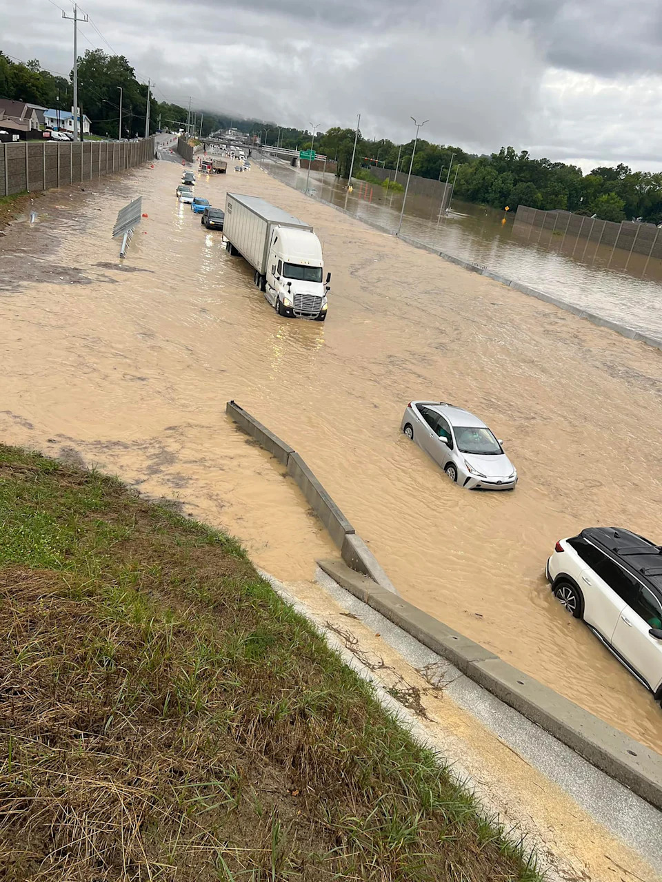
Muddy brown floodwaters turned highways into rivers. One video showed a big rig driving through Interstate 24 with water levels so high it reached the trailer. Video footage also showed cars swirling in floods with water reaching up to the windows.
Yesterday’s road closures included I-24 and I-24. This morning the waters are receding and as of 12:30 a.m. local time, the I-24 was clear and open in both directions.
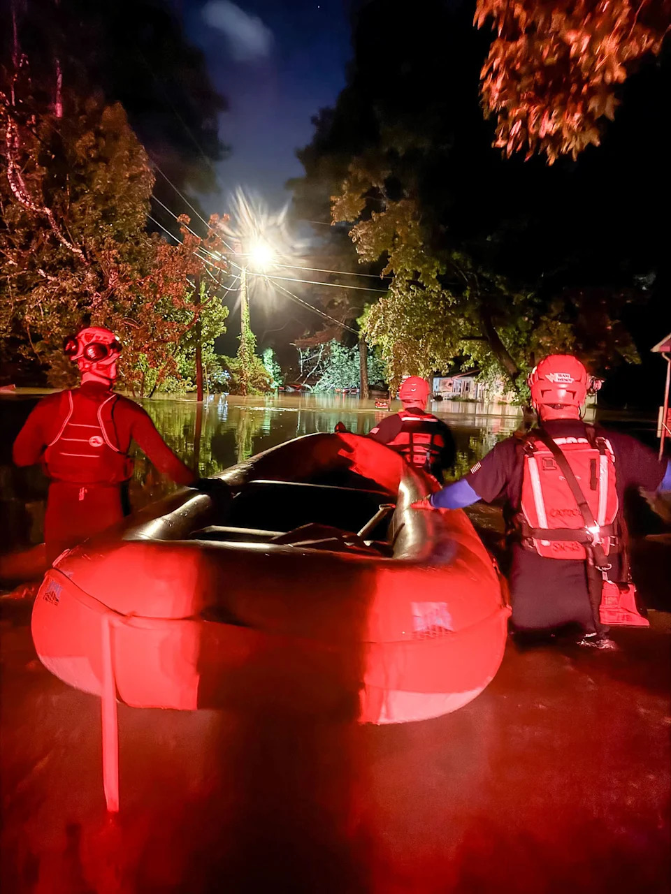
The Chattanooga Fire Department and Hamilton County Sheriff's Office's swift water rescue teams raced to help stranded motorists and locals trapped in their homes.
Six people were rescued by the fire department after a van was nearly swept away in a nearby overflowing creek at Davidson Road and Gunbarrel Road late Tuesday night. No injuries were reported.
“Firefighters spent hours checking sunken cars for any trapped people. This was a large coordinated response effort by city, county and state agencies as flash flooding caused dangerous situations in Chattanooga,” the fire department said.
The Hamilton County Sheriff’s Office also rescued residents trapped by rising flood waters in East Ridge.
“The occupants of three houses were not able to leave their homes due to rising flood waters and swiftwater rescue personnel helped assist them into inflatable boats to safety,” the sheriff’s office said in a Facebook post.
But the rain isn't over just yet.
This morning 6 million people are under a Flood Watch across much of Tennessee and eastern Kentucky where locally heavy rainfall over already saturated soils could lead to additional flash flooding.
Cities in the slight risk for flooding today include Nashville, Chattanooga, Asheville, Knoxville and Greenville-Spartanburg.
Additional areas that can expect heavy rain capable of causing scattered flash flooding include parts of the Gulf Coast as well as the Mid-Atlantic to Northeast.
The Flood Watch warning for middle Tennessee warned excessive rainfall is possible through the evening and excessive runoff could result in flooding in creeks, streams and low-lying locations.
“Widespread flooding is not expected, but localized flash flooding is possible from heavy thunderstorms. Areas that had heavy rain this morning are at greatest risk,” The Flood Watch warning said.
While waters are receding this morning in Chattanooga, flood concerns are growing for residents thousands of miles to the north in Juneau, Alaska, where a glacial outburst is underway.
The Suicide Basin, a glacial lake near the Mendenhall Glacier, periodically releases outburst that causes major flooding along Mendenhall Lake and River.
Juneau officials said in a news release Tuesday a glacial outburst has occurred, and the Suicide Basin is releasing, with flooding expected along Mendenhall Lake and River Tuesday through Wednesday.
Residents are being told to evacuate the potential flood area. Check here for evacuation zones.
A flood warning is in place through 8 a.m. Alaska time Thursday. The Mendenhall River entered into major flood stage of 14 feet as of 12:25 a.m. Wednesday morning local time, and crest is expected this morning around 16.75 feet.
The Army Corps of Engineers is helping the town prepare for what could be a record-setting flood. Thus far the Army has provided 37,800 feet of HESCO barriers, 400 super tacks, 112,000 sandbags and 25,000 feet of polyethylene sheeting.
This article was originally published on NBCNews.com


Comments