As Tropical Storm Erin continues to move quickly to the west, it is expected to start strengthening today, Aug.13, according to the latest advisory from the National Hurricane Center.
Forecasters encourage residents in Puerto Rico, the Virgin Islands and northern Leeward Islands to monitor the progress of the storm.
Erin is expected to strengthen to a hurricane late Thursday, Aug. 14 or early Friday, Aug. 15 and become a major hurricane, Category 3 or higher, with 120-mph winds by Sunday, Aug. 17, according to the National Hurricane Center.
As of Wednesday morning, the impact Erin could have on Florida and the U.S. remains uncertain but officials also encourage residents to monitor the storm.
"There is even greater uncertainty in what impacts might occur in portions of the Greater Antilles, the Bahamas, the east coast of the United States, and Bermuda next week," the National Hurricane Center.
Forecasters reminded everyone that the forecast cone has an average error of 150 to 215 statute miles in the days 4 and 5 forecast. It's also important to remember that the cone represents where the center of the storm could be.
The fifth-named storm of the Atlantic hurricane season, Erin formed earlier than the historical average of Aug. 22.
The average date for the first hurricane is Aug. 11, and the first major hurricane typically does not occur until Sept. 1, according to AccuWeather.
➤ Weather alerts via text: Sign up to get updates about current storms and weather events by location
Tropical Storm Erin update, current path
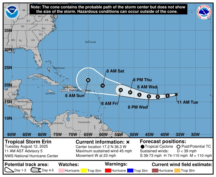
Special note on the NHC cone: The forecast track shows the most likely path of the center of the storm. It does not illustrate the full width of the storm or its impacts, and the center of the storm is likely to travel outside the cone up to 33% of the time.
Location: 1,305 miles east of the northern Leeward Islands
Maximum sustained winds: 45 mph
Movement: west at 17 mph
Pressure: 1,004 mb
Next advisory: 5 p.m. ET
When will Tropical Storm Erin become a hurricane?
The National Hurricane Center predicted Erin will likely become a hurricane by late Thursday Aug. 14 or early Friday.
Erin is expected to continue strengthening, and become a Category 3 storm with 120-mph winds by Sunday, according to the National Hurricane Center.
Spaghetti models for Tropical Storm Erin. Where is the storm going?
Special note about spaghetti models: Illustrations include an array of forecast tools and models, and not all are created equal. The hurricane center uses only the top four or five highest performing models to help make its forecasts.
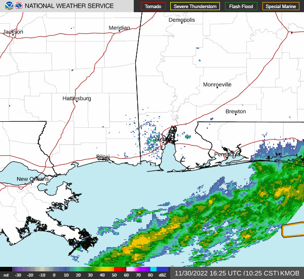
Is there a hurricane coming to Pensacola, Florida?
No tropical storm — or hurricane — watches or warnings have been issued for Florida or the United States, and it's too early to tell whether Erin will impact the U.S., according to the National Hurricane Center, National Weather Service and Florida Division of Emergency Management.
"There is even greater uncertainty in what impacts might occur in portions of the Greater Antilles, the Bahamas, the east coast of the United States, and Bermuda next week," the Hurricane Center said.
A high rip current risk is in effect in Escambia, Santa Rosa and Okaloosa coastal counties until 7 p.m. CDT, according to NWS.
Pensacola weather forecast (Aug. 13-17)
Wednesday, Aug. 13: High 86, low 75. Humid, with a shower and thunderstorm. 96 percent chance of precipitation.
Thursday, Aug. 14: High 91, low 76. Humid with a thunderstorm or two. 88 percent chance of precipitation.
Friday, Aug. 15: High 93, low 75. Humid with a thunderstorm in spots. 80 percent chance of precipitation.
Saturday, Aug. 16: High 94, low 74. Humid with an afternoon thunderstorm. 55 percent chance of precipitation.
Sunday, Aug. 17: High 89, low 75. Humid with a thunderstorm or two. 88 percent chance of precipitation.
See Pensacola weather radar
How strong is Tropical Storm Erin and where could it go? See the scenarios
The National Hurricane Center said Tropical Storm Erin is expected to begin strengthening today, Aug. 13 and become a hurricane by late Thursday or early Friday and a Category 3 hurricane by Sunday, Aug. 17 as it moves out of an area with dry area and "marginal" sea surface temperatures.
Erin is expected to continue moving west across the Atlantic but is expected to turn to the west-northwest as it encounters a weakness in a "ridge" to its north. Exactly where that turn takes place remains uncertain.
"There is even greater uncertainty in what impacts might occur in portions of the Greater Antilles, the Bahamas, the east coast of the United States, and Bermuda next week," the National Hurricane Center said.
"Users are reminded that NHC track forecasts have an average error of 150-215 statute miles at days four and five, and future adjustments to the forecast are still possible."
"At the very least, building seas will pose threats for small craft and larger ocean-going vessels over the western Atlantic. Increasing surf and rip currents will pose dangers for swimmers over much of the U.S. Atlantic coast and Bermuda," AccuWeather forecasters said.
"The amount of wind and rain that occurs over the northeastern Caribbean islands and the Bahamas will depend on Erin's size, intensity and its ability to pull moisture northward from the Caribbean."
"Erin will be guided along by the northeast trade winds initially and then the clockwise circulation around the massive Bermuda High over the central Atlantic," AccuWeather Lead Hurricane Expert Alex DaSilva said.
"It is the shape of that oceanic high, as well as the approach of a cool front and dip in the jet stream near the Atlantic Coast, that will determine the exact track of the projected major hurricane as it approaches the Atlantic Coast of the United States next week."
The scenarios, according to AccuWeather are:
"If the Bermuda High remains fairly round or yields to the approaching cool front and jet stream dip, Erin is likely to turn to the north before reaching the U.S.
"If the Bermuda High extends well to the west, it could block the potential major hurricane's northward path. The result would be a potential track very close to or onshore in the U.S., probably somewhere from the Carolinas north."
Key messages from the National Hurricane Center: What you need to know about Tropical Storm Erin
Erin could move close enough to the northern Leeward Islands, the Virgin Islands, and Puerto Rico over the weekend to produce some impacts on those islands. However, the magnitude of those impacts is still not known, and interests there should continue to monitor the progress of this storm.
There is even greater uncertainty in what impacts might occur in portions of the Greater Antilles, the Bahamas, the east coast of the United States, and Bermuda next week. As we approach the climatological peak of the hurricane season, this is an opportune time to ensure your preparedness plans are in place.
Current forecast: How strong could Tropical Storm Erin get?
At 5 a.m.: 45 mph
12 hours: 50 mph
24 hours: 60 mph
36 hours: 65 mph
48 hours: 75 mph
60 hours: 85 mph
72 hours: 100 mph
96 hours: 115 mph
120 hours: 115 mph
Will Tropical Storm Erin impact Florida? What other areas could be affected?
It's still early to tell yet what impacts Tropical Storm Erin could have on Florida or the United States, although forecasters said rough surf and dangerous rip currents are possible along the east coast as Erin approaches.
Officials warn residents should be prepared and closely monitor the storm that's expected to become a major hurricane by Sunday.
"There is even greater uncertainty in what impacts, if any, might occur in ... the east coast of the United States ... next week," the National Hurricane Center said at 5 a.m. Aug. 13.
Swells generated by Erin will begin affecting portions of the northern Leeward Islands, the Virgin Islands and Puerto Rico by this weekend, according to the National Hurricane Center. "These swells are likely to cause life-threatening surf and rip current conditions."
Interactive map: What tropical storms, hurricanes have impacted your area in the past?
Stay informed. Get weather alerts via text
What's next?
We will update our tropical weather coverage daily.
Download your local site's app to ensure you're always connected to the news. And look for our special subscription offers here.
This article originally appeared on Pensacola News Journal: NOAA hurricane center: Tropical Storm Erin path. Pensacola, FL impact?


Comments