The National Hurricane Center is tracking three systems in the Atlantic basin, including a new homegrown system that appeared near the Yucatan Peninsula late Aug. 12.
Tropical Storm Erin in the central Atlantic is expected to begin strengthening Wednesday, Aug. 13. It's forecast to become a hurricane by Thursday or Friday and a major hurricane Sunday, Aug. 17. A major hurricane is a Category 3 or stronger storm with maximum sustained winds of at least 111 mph.
➤ Weather alerts via text: Sign up to get updates about current storms and weather events by location
Will Tropical Storm Erin impact Texas?
Special note on the NHC cone: The forecast track shows the most likely path of the center of the storm. It does not illustrate the full width of the storm or its impacts, and the center of the storm is likely to travel outside the cone up to 33% of the time.
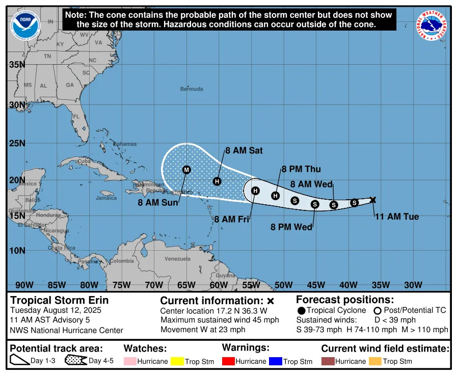
It’s too early to know if Erin will reach the United States at all, but the latest models suggest it’s unlikely the storm will approach the Texas coastline based on its current path.
Still, even if Erin does avoid landfall on the U.S., "there will be a significant increase in seas, surf and rip currents along the East Coast beaches next weekend into the following week," said AccuWeather Senior Meteorologist Chad Merrill.
Here's the latest update on Tropical Storm Erin.
Location: 1,400 miles east of the northern Leeward Islands
Maximum sustained winds: 45 mph
Movement: west at 20 mph
Pressure: 1,004 mb
How does the 2025 Atlantic hurricane season compare to last year in Texas?
While the 2025 season may feel slow compared to last year — which was especially active with 18 named storms, including 11 hurricanes — Erin is actually right on schedule for becoming a hurricane.
According to AccuWeather, the first hurricane usually forms around Aug. 11, the first major hurricane around Sept. 1, and the fifth named storm around Aug. 22 on average.
Erin’s formation comes as forecasters say the season is entering its most active stretch. Colorado State University meteorologists are maintaining their July forecast for a slightly above-average season: 16 named storms, including eight hurricanes and three major hurricanes.
For Texas, the season has been relatively quiet so far — a sharp contrast to mid-August last year, when the state was already six weeks past the final storm to impact the state, which saw the two earliest storms of the 2024 hurricane season.
In late June 2024, Tropical Storm Alberto threatened the Texas, and by early July, the Lone Star State was tracking one one of the hardest-hit hurricanes of the season — Hurricane Beryl, which became the earliest Category 5 storm on record before making its third landfall near Matagorda. After that, the remainder of the season was relatively mild for Texas, with no other storm threatening the state.
No storms have directly affected Texas this season, but forecasters warn the season is ramping up as it nears its peak months in August and September.
What is a 'homegrown' system?
A "homegrown" or "homebrew" storm forms close to the U.S. coast, often in the Gulf of Mexico, the western Caribbean, or the nearby Atlantic. They’re more common early in hurricane season, which runs from June 1 to Nov. 30, according to AccuWeather.
By contrast, Cape Verde hurricanes — which develop from tropical waves off Africa, like Tropical Storm Erin which is forecast to strengthen into a major hurricane by the weekend — make up about 85% of major hurricanes and 60% of all tropical systems. Most stay over open water or weaken before reaching the mainland. From 1995 to 2023, just eight of the 54 hurricanes that hit the U.S. began as Cape Verde systems.
Homegrown storms tend to form or strengthen quickly in warm, shallow waters near shore, leaving little time to prepare. While often shorter-lived or weaker than Cape Verde storms, their proximity can make them the bigger threat to the U.S.
Will the new tropical disturbance impact Texas?
The new system building in the Gulf of Mexico — officially recognized as the Gulf of America by the National Hurricane Center after President Donald Trump issued an executive order renaming the body of water — currently only has a 20% chance of cyclone formation in the next seven days.
"Some development of this system is possible after it emerges across the southwestern Gulf beginning on Thursday while the system moves to the west- northwest or northwest at 10 to 15 mph," according to an advisory from the National Hurricane Center.
It could bring increased rip currents and swells, as well as potentially heavy rainfall and localized flooding to South Texas by this weekend, according to the National Weather Service in Brownsville.
Atlantic storm tracker
This forecast track shows the most likely path of the center of the storm. It does not illustrate the full width of the storm or its impacts, and the center of the storm is likely to travel outside the cone up to 33% of the time.
Tropical Storm Erin spaghetti models
Special note about spaghetti models: Illustrations include an array of forecast tools and models, and not all are created equal. The hurricane center uses only the top four or five highest performing models to help make its forecasts.
When is the Atlantic hurricane season?
The Atlantic hurricane season runs from June 1 through Nov. 30.
Ninety-seven percent of tropical cyclone activity occurs during this time period, NOAA said. The season peaks in August and September.
The Atlantic basin includes the northern Atlantic Ocean, Caribbean Sea and Gulf of America, as the Gulf of Mexico is now known in the U.S. per an order from President Trump. NOAA and the National Hurricane Center are now using Gulf of America on its maps and in its advisories.
Prepare now for hurricanes
Delaying potentially life-saving preparations could mean waiting until it’s too late. "Get your disaster supplies while the shelves are still stocked, and get that insurance checkup early, as flood insurance requires a 30-day waiting period," NOAA recommends.
Develop an evacuation plan: If you are at risk from hurricanes, you need an evacuation plan. Now is the time to begin planning where you would go and how you would get there.
Assemble disaster supplies: Whether you’re evacuating or sheltering-in-place, you’re going to need supplies not just to get through the storm but for the potentially lengthy aftermath, NOAA said.
Get an insurance checkup and document your possessions: Contact your insurance company or agent now and ask for an insurance check-up to make sure you have enough insurance to repair or even replace your home and/or belongings. Remember, home and renters insurance doesn’t cover flooding, so you’ll need a separate policy for it. Flood insurance is available through your company, agent, or the National Flood Insurance Program. Act now, as flood insurance requires a 30-day waiting period.
Create a family communication plan: NOAA said to take the time now to write down your hurricane plan, and share it with your family. Determine family meeting places, and make sure to include an out-of-town location in case of evacuation.
Strengthen your home: Now is the time to improve your home’s ability to withstand hurricane impacts. Trim trees; install storm shutters, accordion shutters, and/or impact glass; seal outside wall openings.
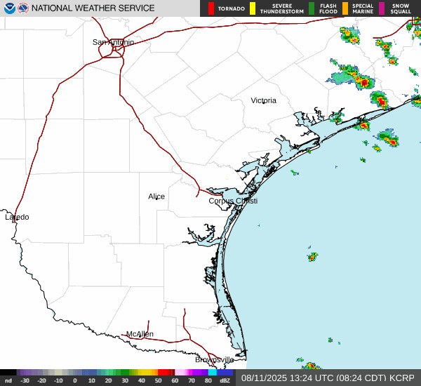
Texas weather radar
Texas weather watches and warnings
Stay informed. Get weather alerts via text
Brandi D. Addison covers weather across the United States as the Weather Connect Reporter for the USA TODAY Network. She can be reached at [email protected].
This article originally appeared on Corpus Christi Caller Times: Tropical system emerging in the Gulf. Will it impact Texas?


Comments