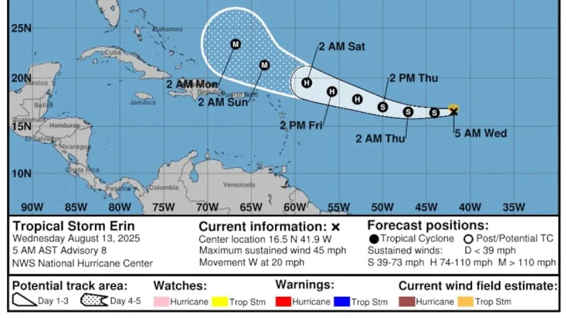
The National Hurricane Center on Wednesday was tracking Tropical Storm Erin, a system in the Atlantic that is likely to charge up to be the first hurricane of the season and could become a major storm over the weekend.
Most long-term models predict Erin will curl away from Florida. Those projections often are unreliable more than a week out, and the hurricane center warned that doubt remains in the forecast. In the four- and five- day range, track forecasts have an average error of about 150 to 215 miles, forecasters said.
“There is even greater uncertainty in what impacts might occur in portions of the Greater Antilles, the Bahamas, the east Coast of the United States, and Bermuda next week,” forecasters wrote in their key messages Wednesday.
But local meteorologist seemed optimistic Wednesday that Erin would make the turn, and not impact the United States.
In a post on Facebook, Denis Phillips, chief meteorologist for ABC Action News, said impacts to the U.S. are likely to be only heavy surf.
In the latest run of the Euro ensemble models, all runs show Erin missing the US, said Jeff Berardelli, chief meteorologist for WFLA, in a post to X. Only a few American ensemble members threaten the coast, but they’re outliers, Berardelli wrote.
“This very good agreement and improvement from yesterday,” Berardelli wrote.
On Tuesday, Erin’s five-day track had inched slightly closer to the Caribbean compared to the previous tracks. By the evening and into Wednesday, the track remained steady.
The long-term models are considered unreliable because there are too many variables when getting past the seven-day mark, and Erin remained likely at least that far away from nearing the U.S.
“It’s way too early to say if (Erin) will impact Florida, or anywhere on the East Coast at this time,” said Eric Oglesby, a meteorologist for Tampa Bay’s National Weather Service on Tuesday.
Oglesby pointed to the track — as the cone widens it shows where the forecast uncertainty grows farther into the future. Over just the next couple of days, the track is skinnier and more reliable.
Models are more dependable in the short-term, particularly with a fast moving storm like this one, he said.
On Wednesday, Erin was about 1,400 miles east of the Northern Leeward Islands, chugging west at a brisk 20 mph. Forecasters expected Erin would continue moving west through Thursday before making the a west-northwest turn, a course it could set through the weekend.
Erin’s sustained winds were near 45 mph, and its tropical-storm-force winds extended out up to 60 miles north of the storm’s center on Tuesday.
Forecasters advised Erin’s risk of moving closer to the northern Leeward Islands, the Virgin Islands and Puerto Rico have increased, and warned residents to monitor the storm.
Erin has had little luck strengthening over the past few days, likely from cooler waters and dry air. However, over the next two days, Erin will meet better environmental conditions and forecasts anticipate it will become a hurricane later this week.
Forecasters expect Erin will become a major hurricane by Sunday, when it could be a Category 3 with wind speeds of at least 111 mph.
Wherever it ends up, the hurricane center advised residents to gather preparedness plans as peak hurricane season approaches. Meteorologists have said they expect this season to be more active than normal.
• • •
Tampa Bay Times hurricane coverage 2025
Here’s a look at the 2025 hurricane season forecasts so far.
What to know about river flooding in Tampa Bay this hurricane season.
Here are the lessons you learned from Tampa Bay’s historic 2024 hurricane season.


Comments