Tropical Storm Erin is expected to intensify into the first major hurricane of the season, according to the National Hurricane Center.
The storm formed near the Cabo Verde Islands over the weekend and has strengthened. “Erin will enter an area with conducive atmospheric conditions that will allow it to quickly strengthen north of the Lesser Antilles," AccuWeather lead hurricane Expert Alex DaSilva said in a press release. “Water temperatures across much of the Atlantic main development region are plenty warm to support tropical development and even rapid intensification."
Here's what to know about the track of Tropical Storm Erin.
Where is Tropical Storm Erin?
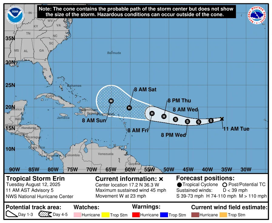
Special note on the NHC cone: The forecast track shows the most likely path of the center of the storm. It does not illustrate the full width of the storm or its impacts, and the center of the storm is likely to travel outside the cone up to 33% of the time.
NOAA hurricane tracker: See spaghetti models for Tropical Storm Erin
Special note about spaghetti models: Illustrations include an array of forecast tools and models, and not all are created equal. The hurricane center uses only the top four or five highest performing models to help make its forecasts.
Who is likely to be impacted by Tropical Storm Erin?
It's too early at this time to determine if there will be any impact to Massachusetts, the rest of New England or the U.S. from Tropical Storm Erin.
The track will be determined by "positioning of the Bermuda high and the strength of a cold front pushing off the East Coast." according to AccuWeather.
The storm could be turned out to sea or set a track for the track depending on conditions.
“If the trough is stronger and faster, it will help steer Erin away from the East Coast and out to sea," DaSilva said. "This is the scenario we typically see with recurving storms. If the trough is slower, the storm will be able to advance farther westward toward the coast of the Carolinas."
Regardless, the chance of New England seeing any of the effects of the storm are "low," according to AccuWeather.However, those visiting beaches along the East Coast later this week and through the weekend should be vigilant of rough surf, learn the warning signs of rip currents, and only swim in areas with lifeguards on duty, AccuWeather stressed in a release.
The National Oceanic and Atmospheric Administration (NOAA) explained that "rip currents are powerful, narrow channels of fast-moving water... Moving at speeds of up to eight feet per second, rip currents can move faster than an Olympic swimmer."
If you encounter a rip current, swim parallel to the shore and then back at an angle, according to NOAA.
What tropical waves, disturbances are in Atlantic basin now?
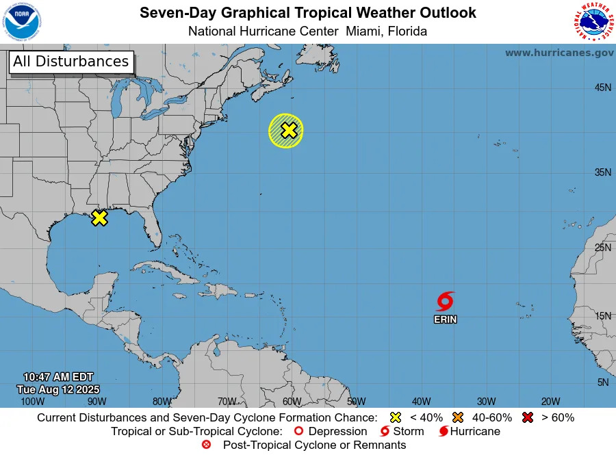
Northwestern Atlantic: A non-tropical area of low pressure located a few hundred miles southeast of Nova Scotia, Canada, is producing disorganized shower and thunderstorm activity to the west of its center. Somelimited tropical or subtropical development is possible over the next day or so as the low meanders near the relatively warm waters of the Gulf Stream. The system is expected to move northward over cooler waters by Wednesday, ending its chances for tropical development.
Formation chance through 48 hours: low, 10 percent.
Formation chance through seven days: low, 10 percent.
Northeastern Gulf: A surface trough near the coast of Louisiana is producing a broad area of disorganized showers and thunderstorms. While development of this system is not anticipated before it moves inland latertoday, locally heavy rainfall could produce flash flooding across portions of the northern Gulf coast over the next day or so.
Formation chance through 48 hours: near 0 percent.
Formation chance through seven days: near 0 percent.
What's the hurricane outlook for the 2025 season?
The AccuWeather 2025 Atlantic hurricane season forecast is predicting 13-18 named storms, including 7-10 hurricanes, adding "Three to six direct U.S. impacts are forecast, the same range as last year’s catastrophic season with six landfalls."
The report noted that the climatological peak of hurricane season begins Sept. 10.
What is the NOAA forecast on hurricanes in 2025?
NOAA is forecasting a range of 13 to 19 total named storms. Of those, 6 to 10 are forecast to become hurricanes, including 3 to 5 major hurricanes.
Cheryl McCloud contributed to this report.
This article originally appeared on Cape Cod Times: Tropical Storm Erin expected to become hurricane. Will it impact MA?


Comments