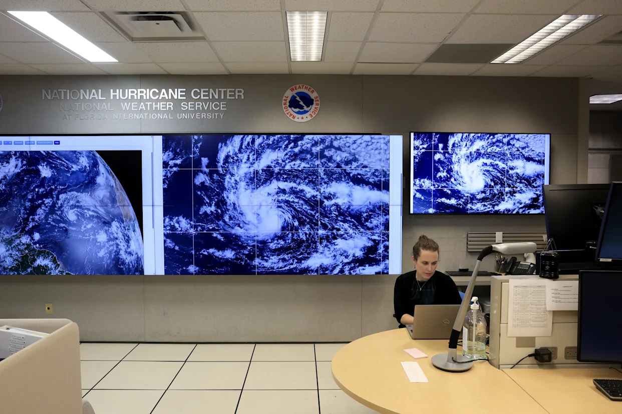
The peak of the hurricane season is upon us and forecasters are still anticipating higher than normal levels of activity, despite a relatively calm season so far.
As of Wednesday afternoon, Tropical Storm Erin is churning in the Atlantic Ocean and moving toward the Caribbean, likely to become the season’s first hurricane, a storm with sustained winds above 74 miles per hour.
The National Hurricane Center says it’s too early to predict the storm’s impacts but advises people on the East Coast of the US “to ensure your preparedness plans are in place.”
The hurricane season officially runs from June 1 until November 30 and typically has 14 storms strong enough to be named, meaning with wind speeds above 39 mph. This year is anticipated to be busier than usual, with forecasters expecting up to 18 named storms, and up to five that will turn into major hurricanes. That’s due in part to the El Niño cycle, which is currently in its neutral phase, creating atmospheric conditions more favorable to tropical storms. The surface of the Atlantic Ocean remains at above-average temperatures, and since hurricanes are powered by hot water, Erin may become the first major hurricane of the year.
“As we enter the second half of the season, this updated hurricane outlook serves as a call to action to prepare now, in advance, rather than delay until a warning is issued,” acting NOAA Administrator Laura Grimm said in a news release.
But a tropical storm doesn’t have to reach hurricane strength to cause death and destruction. The remnants of Tropical Storm Barry last month stalled over Texas, where they converged with another weather system and caused a massive downpour that led to deadly flooding in the state’s hill country.
A key step to saving lives from tropical storms and hurricanes is to anticipate where they might go and get people out of the way. On this front, scientists have made tremendous strides in building longer lead times ahead of a storm’s landfall, and new tools are continuing to extend that lead. But the Trump administration’s recent cuts to departments that study and forecast weather are undermining this progress, while cuts to emergency agencies are slowing disaster responses.
Erin could be a major test of the results of these actions.
How hurricanes work, and how our decisions make them worse
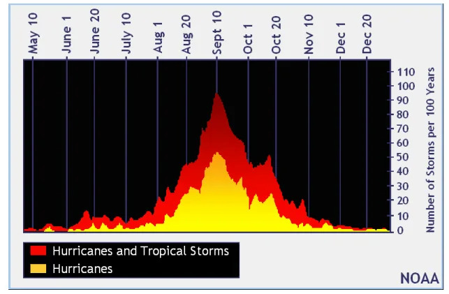
Meteorologists often describe hurricanes as heat engines, meaning that they use a temperature difference to generate wind and rain. But to start up, a hurricane needs sea surface temperatures to be around 80 degrees Fahrenheit or hotter. This is why the apex of hurricane activity tends to be in September, after the Atlantic Ocean has had all summer to heat up.
Generally, the hotter the water, the more powerful the resulting storm. “For every degree centigrade that you raise the ocean temperature, the wind speed in the hurricane goes up between 5 and 7 percent,” Kerry Emanuel, an emeritus professor of atmospheric science at the Massachusetts Institute of Technology, told Vox last year. With global average temperatures rising due to climate change, the potential for more powerful hurricanes is increasing.
A warmer planet also means rising sea levels as ice caps melt, adding more liquid to the seas. The ocean itself also expands as it gets hotter. So when a hurricane occurs, its winds create a larger storm surge as it pushes water inland. Warmer air can also hold onto more moisture, increasing the rainfall during a hurricane. The combined effects of storm surge and more intense rainfall can lead to more flooding, often the deadliest and most destructive aspect of a hurricane. And as the floods in Texas this year showed, even areas that are far inland can suffer severely from hurricane storm systems.
Since hurricanes spin counter-clockwise, these effects tend to be stronger on the right side of the storm — sometimes called the “dirty side” — where the wind is blowing in the same direction as the storm is moving.
On the other side of the equation, more people are living in the paths of hurricanes. In the US, about 40 percent of the population lives in a coastal county, and the numbers are growing. So when a hurricane makes landfall, it threatens more lives and takes a bigger bite out of the economy.
The good news is that scientists have made huge strides in anticipating hurricanes and can now predict where they are going days in advance. A modern hurricane track forecast looking 72 hours ahead is better than a 24-hour forecast in the early 90s. Last year, the National Oceanic and Atmospheric Administration deployed a new prediction model called the Hurricane Analysis and Forecast System. It proved to be better than previous models at predicting a storm’s path and intensity.
In recent years, a number of hurricanes have undergone rapid intensification, where they gain more than 35 miles per hour in wind speed in less than 24 hours. It makes storms harder to predict, and makes evacuating people in their path more hasty and chaotic, as hurricanes surge in strength. Scientists are still trying to tease out the mechanisms behind rapid intensification, but the new model was able to see the rapid intensification coming in Hurricanes Helene and Milton from their earliest advisories, days before landfall.
But while NOAA has made improvements in its forecasts, the agency itself has faced big cuts from the Trump administration, including staff who work on hurricane modeling. The White House has proposed cutting its budget by a quarter, eliminating research divisions like the Office of Oceanic and Atmospheric Research, which studies hurricanes. Several field offices for the National Weather Service under NOAA currently lack lead meteorologists, and key forecasting tools like weather balloon launches have seen a decline. The National Weather Service is now scrambling to hire back hundreds of employees. All of this adds an unnecessary layer of chaos to an already dangerous situation.
The true scope of these vulnerabilities won’t be revealed until after a major hurricane. Already, emergency responders in some parts of the country are getting the message that help from higher up in the government isn’t coming, while homeowners are getting the sense that they’re on their own when facing extreme weather. And even if the US dodges the worst of Erin, there are still more than two months left in the hurricane season, which has yet to reach its peak.


Comments