As Tropical Storm Erin continues to spin in the Atlantic Ocean, New Yorkers may need to skip some beach days as it could create dangerous rip currents on the East Coast.
AccuWeather meteorologists say that while Erin may not directly affect the East Coast, some storm fragments and rough tides may impact states along the East Coast and the Caribbean.
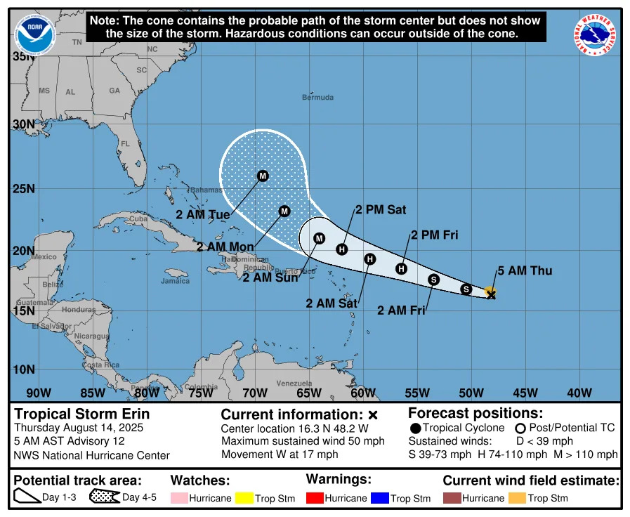
By the week of Aug. 18, AccuWeather Hurricane Expert Alex DaSilva says Bermuda, Puerto Rico and Caribbean islands could get slammed with two to four inches of rainfall and 60 to 80 mile-per-hour wind gusts after the tropical storm turns into a hurricane by Friday, Aug. 15, or Saturday, Aug. 16.
DaSilva says Erin could even become a Category 3 hurricane at its strongest, likely just missing landfall in the U.S. by "a few hundred miles."
“Based on current conditions, forecast atmospheric patterns for the next week, and historical hurricane tracks for this time of year, AccuWeather estimates a 70 percent probability that Erin will not directly impact the U.S. East Coast at this time,” DaSilva said.
Storm watch: Where is Tropical Storm Erin? See our online storm tracker, latest info from NWS
East Coast at risk of rip currents and rough surf
DaSilva said families taking trips to Atlantic beaches between Aug. 15 and Aug. 22 should be careful entering the waters, as over 50 people have been killed by rip currents and rough surf in the U.S. in 2025.
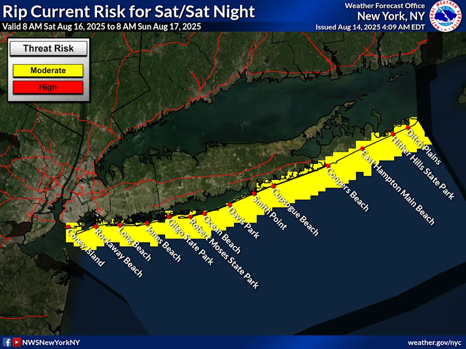
In North America, North Carolina's Outer Banks, parts of Long Island and New York City's coastal areas and Canada's Atlantic Coast are expected to see the strongest rip currents and tides.
According to a forecast hazard map issued by the National Weather Service Thursday, there's a "moderate" risk for life-threatening rip currents Saturday, Aug. 16 along Long Island's South Shore.
If Erin intensifies into the Atlantic's first major hurricane of the season, DaSilva said wind gusts could reach between 111 and 129 miles per hour.
Families vacationing in the Caribbean during this time should also take major precautions or rethink their travel dates.
Heavy rains, strong winds could put strain on Caribbean power grid
AccuWeather predicts between 2 to 7 inches of torrential rains could flood parts of the Caribbean as a result of the storm, as well as 40 to 80 mile-per-hour wind gusts, which could debilitate already strained power sources in the islands.
However, compared to past hurricanes, AccuWeather gives Tropical Storm Erin's impact level a "less than one" on its RealImpact Scale for Hurricanes.
"A less than one on the AccuWeather RealImpact Scale for Hurricanes warns of limited damage from wind and rain, as well as coastal inundation resulting in some property damage," the forecasting website said.
Where is Tropical Storm Erin right now?
See the map below to track Tropical Storm Erin's path over the Atlantic Ocean.
Atlantic hurricane season to ramp up in August
This year's hurricane season started on June 1 and will last until Nov. 30, with the most storm activity seen from mid-August to mid-October.
This year, the National Oceanic and Atmospheric Administration says there is an 60% chance of around 13 to 19 named storms that could form, with wind gusts 29 mph or higher.
Of the predicted named storms in 2025, six to 10 are predicted to become hurricanes with winds of 74 miles per hour or higher, and three to five may become major hurricanes with winds 100 miles per hour or higher.
AccuWeather predicts that three to five named storms could develop in the Atlantic in August, including Erin and Tropical Storm Dexter, which fizzled out in the open ocean Aug. 9.
This article originally appeared on Rockland/Westchester Journal News: Will Tropical Storm Erin hit NY? See how storm could effect East Coast


Comments