Will Erin impact Florida? Here's what forecasters are saying.
Tropical Storm Erin was beginning to strengthen — as expected — Aug. 14.
Erin is expected to become the season's first hurricane Friday, Aug. 15, and a major hurricane by Sunday, Aug. 17. A major hurricane is a Category 3 or stronger storm with maximum sustained winds of at least 111 mph.
➤ Weather alerts via text: Sign up to get updates about current storms and weather events by location
As of 1 p.m. Thursday, Aug. 14, the forecast calls for Erin's winds to increase to 125 mph within five days, making it a strong Category 3 storm. A Category 4 storm has maximum sustained winds of at least 130 mph.
While currently moving west across the Atlantic, Erin is expected to start a curve to the north while north of Puerto Rico. If it does, it'll remain over open water, away from Florida and the U.S. east coast.
Here's what forecasters are predicting impacts could be for Florida or the east coast.
Tropical Storm Erin update, path
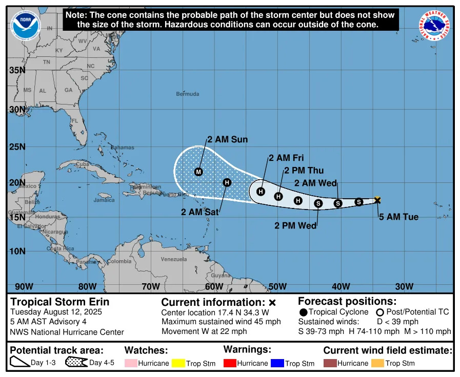
Special note on the NHC cone: The forecast track shows the most likely path of the center of the storm. It does not illustrate the full width of the storm or its impacts, and the center of the storm is likely to travel outside the cone up to 33% of the time.
Spaghetti models for Tropical Storm Erin
Special note about spaghetti models: Illustrations include an array of forecast tools and models, and not all are created equal. The hurricane center uses only the top four or five highest performing models to help make its forecasts.
See graphics, satellite images of Tropical Storm Erin
What are expert forecasters predicting for Florida from Tropical Storm Erin?
Here is a roundup of potential impacts to Florida and the U.S. east coast from Tropical Storm Erin.
WeatherTiger: Erin no cause for concern
"Though Erin should be a formidable hurricane next week, it isn’t cause for concern," said Dr. Ryan Truchelut on Aug. 13. Truchelut is the chief meteorologist at WeatherTiger, and works with the USA TODAY Network.
➤ Hurricane drama vs. data: Why Erin is a miniscule threat to Florida, U.S. east coast
Erin’s center should remain well east of the U.S. East Coast, which "means the already slim chances of Erin posing eventual U.S. landfall risks are narrowing further,"
"I’d say there’s a 5% (or lower) possibility of Erin threatening the continental U.S. next week," Truchelut said.
"Erin will cause heavy surf and rip currents along the Eastern Seaboard starting mid-next week, but nothing in the way of rain, surge, or wind."
National Hurricane Center: Tropical Storm Erin could bring dangerous surf, rip currents
Tropical Storm Erin is becoming better organized and was strengthening Thursday, Aug. 14.
It's expected to become a hurricane Friday morning and a major hurricane — with maximum sustained winds of 125 mph — Sunday, Aug. 17.
"While there is still uncertainty in what impacts might occur in portions of the Bahamas, the east coast of the United States, and Bermuda next week, the risk of dangerous surf and rip currents across the western Atlantic basin next week is increasing," the National Hurricane Center said.
National Weather Service: Beach, boating conditions to deteriorate
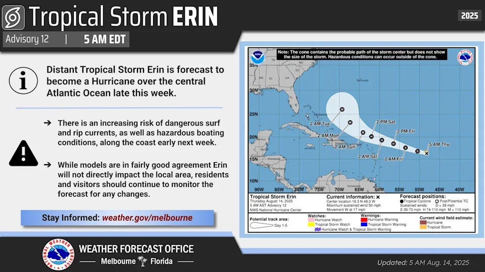
The National Weather Service Melbourne said residents should continue to monitor Tropical Storm Erin as it moves across the Atlantic.
"A turn prior to reaching the Bahamas would lead to minimal impacts for east central Florida. However, beach and boating conditions are expected to deteriorate early next week, regardless of the exact track of the storm."
On X, the National Weather Service Melbourne said "there is an increasing risk of dangerous surf and rip currents, as well as hazardous boating conditions, along the coast early next week.
AccuWeather: Big waves likely from Florida to Maine
“I would give it about a 70 percent chance that Erin stays well off the U.S. coastline and brings no direct impacts to the United States," said AccuWeather Lead Hurricane Expert Alex DaSilva via email Aug. 13.
"There is a roughly 30 percent chance that it could come close enough to the Carolinas to potentially bring some wind and some rain impacts.
"“I think the biggest impact to the United States is going to be the risk of dangerous rip currents and rough surf. We're going to see some really massive waves out in the middle of the Atlantic churned up by Erin," DaSilva said.
"Later on next week, we will likely see some big time waves up and down the entirety of the East Coast from Florida all the way to Maine.”
Fox Weather: Florida residents should watch for rip currents, strong undertows
Tropical Storm Erin's most likely track next week would be between the U.S. and Bermuda, said Fox Weather hurricane specialist Bryan Norcross via email Aug. 13.
"A low probability, but not implausible scenario is for the storm to come close enough to Cape Hatteras and perhaps Cape Cod to directly affect those areas late next week.
"More likely, the biggest impact on the U.S. East Coast will be from dangerously strong ocean currents and large waves generated by the hurricane well offshore, with a relatively minor impact on the weather," Norcross said.
"The only effects likely in Florida will be from the long-period swells impacting the coast from Palm Beach County north. The Florida coast won't be affected anywhere near as much as the points north, especially from the Carolinas to New England, but rip currents and an extra-strong undertow with larger than normal waves are likely."
The Weather Channel's Jim Cantore: 'Some guidance' showing Erin could become Cat 4 hurricane
The Weather Channel posted on its website Tropical Storm Erin could become a hurricane as early as Thursday night, with a track that has been trending west and south over the last few days.
The Weather Channel's meteorologist Jim Cantore posted on X some models are showing Tropical Storm Erin could reach Category 4 strength.
"The probability of a landfall from Erin along the U.S. East Coast is low at this time. However, interests along the East Coast should continue to monitor this system for possible changes. Erin will generate high surf and dangerous rip currents along the U.S. East Coast next week, no matter where it tracks," The Weather Channel said.
FloridaStorms: Seas expected to be unsafe for boaters, swimmers
The Florida Public Radio Emergency Network said Aug. 13 it expected Erin to start turning north over the weekend.
"We forecast Erin to be turning especially late on Sunday, early Monday morning, and be well over 700 miles east of Miami.
"Considering it will be a major hurricane with very strong winds staying offshore, the seas will become very agitated. We expect large swells along the east seaboard from the east coast of Florida through pretty much the northeast.
"Beach conditions will begin to deteriorate early next week, and the seas are likely to remain unsafe for boaters or swimmers through much of the following workweek."
Mike's Weather Page: Erin may 'split the gap' between US, Bermuda
Tropical Storm Erin is "too close not to watch," for both Bermuda and the U.S. east coast, Mike's Weather Page posted on X.
For a deep dive into what Mike's Weather Page has to offer on Tropical Storm Erin, go to the Daily Brew for Aug. 14 on YouTube.
Florida Division of Emergency Managment: 'No direct threat to Florida'
Erin poses no direct threat to Florida at this time but continues to be monitored, the Florida Division of Emergency Management said.
Stay informed. Get weather alerts via text
What's next?
The USA TODAY Network in Florida provides daily updates of tropical weather coverage.
Download your local site's app to ensure you're always connected to the news. And look for our special subscription offers here.
This article originally appeared on Naples Daily News: Tropical Storm Erin Florida impacts, from NOAA, AccuWeather, Fox, NWS


Comments