Severe thunderstorms could bring strong wind gusts, flooding and possible tornadoes to southeastern Wisconsin, according to a flurry of alerts put out by the National Weather Service Aug. 16.
The National Weather Service placed Milwaukee and large swaths of southeastern, south-central, and east-central Wisconsin under a flood watch around noon.
Meanwhile, areas to the north and northwest of Milwaukee were placed under a severe thunderstorm warning.
The flood alerts come as the Milwaukee area continues to regroup a week after experiencing historic flooding.
The National Weather Service says the forecast is highly variable. Here's the latest:
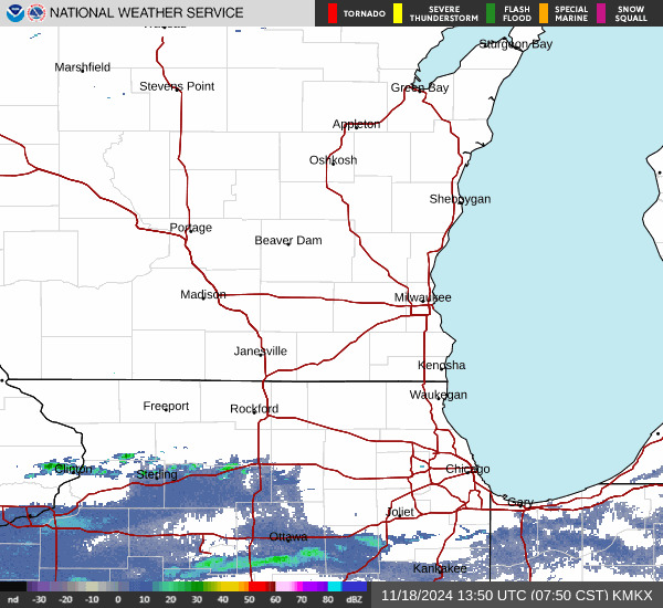
20 Wisconsin counties placed under flood watch until morning of Aug. 17
South-central and east-central Wisconsin were placed in a flood watch from 4 p.m. Aug. 16 through the morning of Aug. 17. The NWS expects "repeated rounds of thunderstorms with heavy rainfall rates" to potentially cause ponding on roads, with urban areas especially at risk.
"Flooding may occur in poor drainage and urban areas," the NWS flood watch alert said. "Area creeks and streams are running high and could flood with more heavy rain."
The flood watch — different from a flash flood warning — stretched from west of Mineral Point to Milwaukee in the east, with south of Janesville and northwest of the Wisconsin Dells included. A flood watch is issued when conditions are favorable for flooding, while a flash flood warning means flooding is imminent or occurring.
Lower Fox River in Waukesha County under flood warning until Aug. 17 afternoon
The NWS issued a flood warning for the Lower Fox River in Waukesha, predicting minor flooding. The warning is in effect until the afternoon of Aug. 17.
It urged people to be cautious when walking near riverbanks and motorists to not drive around barricades or through flood areas.
Severe thunderstorm warning in Iowa, Dane and Sauk counties until 1:30 p.m.
The NWS issued a severe thunderstorm warning for northeastern Iowa County, northwestern Dane County and Southeastern Sauk County until 1:30 p.m.
The warning indicated a storm could bring wind gusts up to 60 miles per hour and quarter-sized hail. The storm was located 7 miles northeast of Spring Green and moving east at about 30 miles per hour.
Impacted locations include Prairie Du Sac, Sauk City, Cross Plains, Mazomanie, Black Earth, Arena, Plain and Marxville.
Thunderstorm warning in northern Ozaukee County, surrounding area until 1 p.m.
The NWS issued a severe thunderstorm warning for northern Ozaukee County, southeastern Fond du Lac County, Columbia County, Washington County, Dodge County and Sheboygan County until 1 p.m.
The warning indicated storms were moving southeast at 40 miles per hour and expected to bring wind gusts up to 60 miles per hour.
The NWS urged people in the area to monitor for tornadoes and move to an interior room on the lowest floor of a building.
Impacted locations include: Sheboygan, West Bend, Watertown, Beaver Dam, Hartford, Plymouth, Sheboygan Falls, Jackson, Mayville, Slinger, Columbus, Kewaskum, Horicon, Howards Grove, Juneau, Oostburg, Lomira, Belgium, Fredonia, and Kohler.
The NWS urged people at the Dodge County Fair in Beaver Dam to seek safe shelter immediately.
This article originally appeared on Milwaukee Journal Sentinel: Thunderstorm warnings, flood watches issued for southeastern Wisconsin


Comments