As Hurricane Erin travels along the Caribbean, two other disturbances are being tracked in the Atlantic, according to the National Hurricane Center.
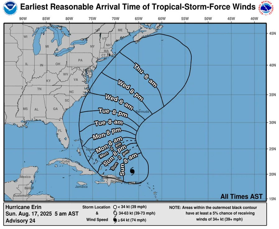
On Sunday, Aug. 17, at 5 a.m. ET, the National Hurricane Center announced that over the next several days, Erin is expected to produce "life-threatening" surf and rip currents at beaches in the Bahamas, the East Coast of the U.S. Bermuda and Atlantic Canada.
As of Sunday morning, the storm is a Category 3 hurricane, according to AccuWeather. But, it is forecast to become a Category 4 on Sunday afternoon.
At 8 a.m. ET, the hurricane center issued an advisory for Hurricane Erin, located north of the Lesser Antilles, a chain of islands in the eastern Caribbean Sea southeast of Puerto Rico.
Heavy rains are expected to continue across Puerto Rico and the Virgin Islands on Sunday, and flash and urban flooding, landslides and mudslides could impact the islands, according to hurricane center.
The hurricane center is tracking two other disturbances. The first is around 200 miles off the coast of North Carolina, which has a low chance of formation, 10%, over the next seven days. Another disturbance, a tropical wave near the Cabo Verde Islands located west of the coast of Senegal in Africa, also has a low chance, 20%, of developing over the next seven days.
Powerful Hurricane Erin: Storm could mimic damage from earlier hurricanes that stayed offshore
Caribbean islands impacted by Hurricane Erin
On Monday, Aug. 18, the Turks and Caicos Islands are expected to face tropical storm conditions, while those conditions are also possible in the Southeast Bahamas the night of Aug. 17 and throughout Aug. 18.
"Gusts to tropical storm force are possible in Erin's outer rainbands in portions of Puerto Rico today, (Aug. 17), and in the central Bahamas on Monday, (Aug. 18), and Tuesday (Aug. 19)," the hurricane center said.
Hurricane Erin could be near the southeast portion of Florida by Monday, Aug. 18 at 8 p.m. ET.
Storm tracker: Tracking storms in the Atlantic
Spaghetti models for Hurricane Erin
This forecast track shows the most likely path of the center of the storm. It does not illustrate the full width of the storm or its impacts, and the center of the storm is likely to travel outside the cone up to 33% of the time.
When did the 2025 hurricane season begin?
The Atlantic hurricane season officially began on June 1 and will last through the end of November.
Active hurricane weather typically peaks between mid-August and mid-October.
How do hurricanes form?
Hurricanes are born in the tropics, above warm water. Clusters of thunderstorms can develop over the ocean when water temperatures exceed 80 degrees Fahrenheit. If conditions are right, the clusters swirl into a storm known as a tropical wave or tropical depression.
A tropical depression becomes a named tropical storm once its sustained wind speeds reach 39 mph. When its winds reach 74 mph, the storm officially becomes a hurricane.
Prepare now for hurricanes
Delaying potentially life-saving preparations could mean waiting until it’s too late. "Get your disaster supplies while the shelves are still stocked, and get that insurance checkup early, as flood insurance requires a 30-day waiting period," NOAA recommends.
Prepare now for hurricanes: Here's what you should do to stay safe before a storm arrives
Develop an evacuation plan: If you are at risk from hurricanes, you need an evacuation plan. Now is the time to begin planning where you would go and how you would get there.
Assemble disaster supplies: Whether you’re evacuating or sheltering in place, you’re going to need supplies not just to get through the storm but for the potentially lengthy aftermath, NOAA said.
Get an insurance checkup and document your possessions: Contact your insurance company or agent now and ask for an insurance check-up to make sure you have enough insurance to repair or even replace your home and/or belongings. Remember, home and renters insurance doesn’t cover flooding, so you’ll need a separate policy. Flood insurance is available through your company, agent or the National Flood Insurance Program. Act now, as flood insurance requires a 30-day waiting period.
Create a family communication plan: NOAA said to take the time now to write down your hurricane plan, and share it with your family. Determine family meeting places, and make sure to include an out-of-town location in case of evacuation.
Strengthen your home: Now is the time to improve your home’s ability to withstand hurricane impacts. Trim trees; install storm shutters, accordion shutters and/or impact glass; seal outside wall openings.
Julia is a trending reporter for USA TODAY. Connect with her on LinkedIn, X, Instagram and TikTok: @juliamariegz, or email her at [email protected]
This article originally appeared on USA TODAY: Where is Hurricane Erin headed? See tracker, forecast map


Comments