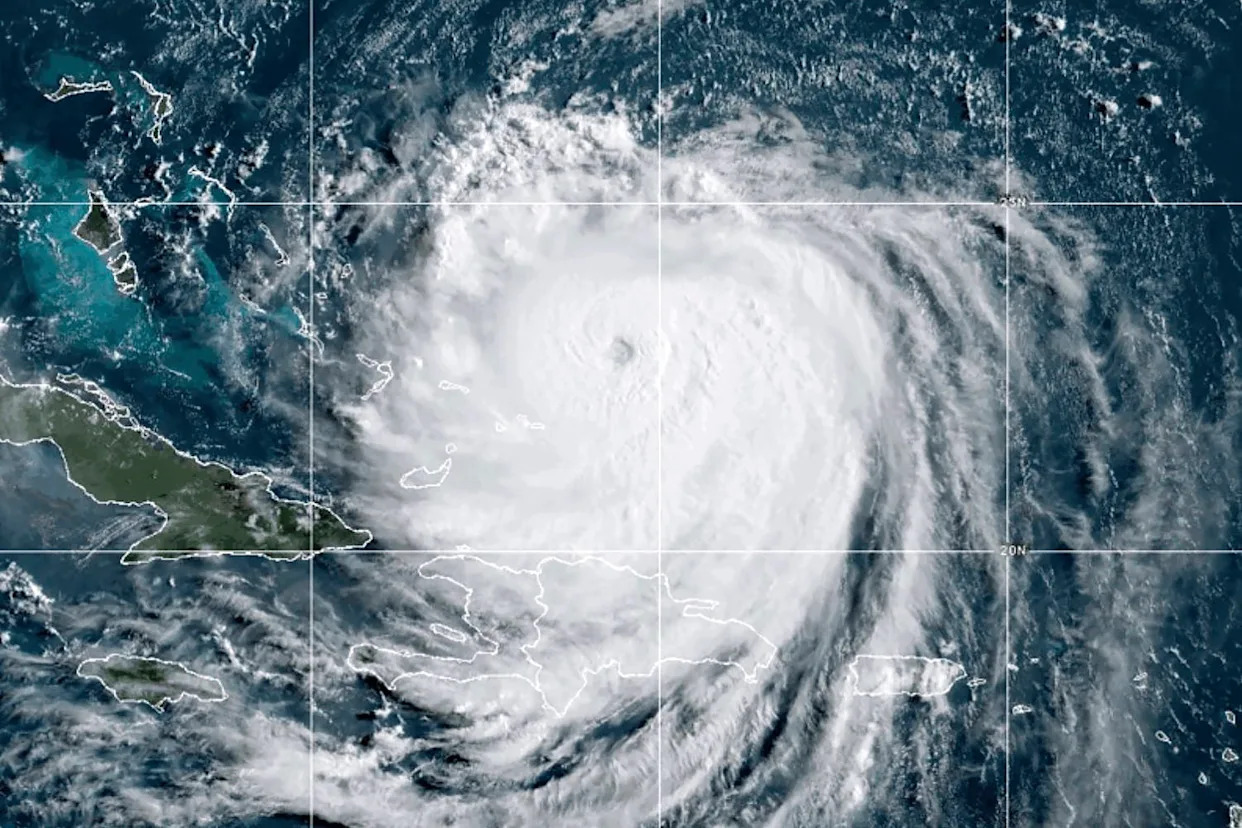
Erin strengthened back into a Category 4 hurricane late Sunday night and maintained maximum sustained winds around 130 mph into Monday morning as it moved northwest, parallel to the Bahamas.
New data collected from Hurricane Hunters shows that Erin has grown larger. Hurricane- and tropical-storm-force winds now extend up to 70 and 200 nautical miles from the eye, respectively. Erin’s eyewall has also grown and is now about 30 nautical miles in diameter, according to the National Hurricane Center.
There is an indication that Hurricane Erin again has cocentric eyewalls, which is a common phenomenon called an eyewall replacement.
➤ Spaghetti models for Hurricane Erin
"This means that as the old eyewall expands outward, a new eyewall forms closer to the center," AccuWeather Meteorologist Brandon Buckingham said. "Top winds often ease back during this cycle, but it is followed by another surge in wind intensity as the new eye completes organization.”
A bigger Hurricane Erin doesn’t substantially change things for people living along Florida’s eastern coast at the moment, but residents should continue to monitor the storm for potential shifts, especially as Erin has wobbled more westward over the past six hours.
Hurricane Erin’s path is still expected to continue northwest before gradually turning more northward later today and Tuesday as it moves into a weakness within the subtropical ridge, according to the NHC’s 7 a.m. advisory.
Here’s what Floridians need to know about Hurricane Erin.
Quick facts about Hurricane Erin
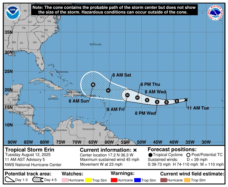
Erin, still a Category 4 hurricane, is located about 110 miles north of Grand Turk Island and 880 miles south-southeast of Cape Hatteras, North Carolina.
The storm is moving northwest at 10 mph and is still expected to make a gradual turn northward later today and on Tuesday, where it will pass between the U.S. and Bermuda by mid-week.
Maximum sustained winds increased up to 140 mph, with hurricane-force winds extending outward up to 80 miles from the center, and tropical-storm-force winds extended outward up to 230 miles.
Location: 110 miles north of Grand Turk Island and 880 miles south-southeast of Cape Hatteras, North Carolina
Maximum wind speeds: 140 mph
Movement: West-northwest (300 degrees) at 10 mph
Minimum central pressure: 935 mb
Is Hurricane Erin coming to Florida?
While Hurricane Erin has shifted a bit farther west, the storm is still not expected to directly impact Florida. AccuWeather forecasters currently expect virtually no rain or wind impact from the storm, but breach conditions could be another story.
Due to Erin’s massive size, it’s still likely to create dangerous conditions for swimmers across the country’s entire eastern coast. The NHC warns that Erin is expected to produce life-threatening surf and rip currents along much of the East Coast over the next several days.
The Outer Banks of North Carolina and Bermuda are the two areas most likely to see the greatest risk of impact, according to the NHC. Tropical storm conditions and coastal flooding are possible starting late Wednesday, and tropical storm and storm surge watches may be issued later Monday.
What should you do if you live in Florida?
Unless forecasts change, Hurricane Erin poses no direct risks for Florida residents, although life-threatening rip currents and dangerous surf are expected.
Remember we are in the busiest period of hurricane season.
Now is the time to:
Keep an eye on weather updates. and make sure you monitor the latest conditions.
Hurricane Erin’s current impacts
Hurricane Erin is expected to bring bands of heavy rain over portions of Hispaniola on Monday, and through Tuesday for the Turks, Caicos and the Bahamas eastward from San Salvador Island. Flash and urban flooding are possible throughout these areas.
The Turks and Caicos Islands and the southeast Bahamas are expected to see tropical storm conditions on Monday. Erin is also expected to product life-threatening surf and rip currents along beaches in the Bahamas.
Hurricane Erin spaghetti models
Special note about spaghetti models: Illustrations include an array of forecast tools and models, and not all are created equal. The hurricane center uses only the top four or five highest performing models to help make its forecasts.
Contributors: Cheryl McCloud - USA TODAY NETWORK-FLORIDA.
This article originally appeared on Pensacola News Journal: Hurricane Erin is getting bigger. What that means for Florida


Comments