Final storm brings more flash flooding risk to Minnesota; impact to morning commute originally appeared on Bring Me The News.
Flash flood warnings could continue to be issued in Minnesota on Monday morning as one final storm system brings heavy rain to the southern half of the state.
The flood watch issued on Sunday remains in place through the morning, with the NWS saying new showers and storms "will lead to a chance for additional flooding and flash flooding," while also noting that the Twin Cities could be impacted during the morning commute.
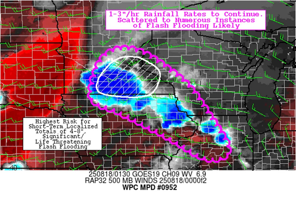
On Sunday evening, the National Weather Service Mesoscale Precipitation Discussion said there was a risk of potentially "life-threatening flooding" over southern Minnesota, including parts of the Twin Cities, with the potential for 4-8 inches of rain to fall in some areas.
Fortunately, overnight flooding didn't reach "life-threatening" level in most of the area, with the NWS Twin Cities saying there was "just enough of a lull from roughly 11 p.m to 3 a.m." to allow the ground to recover and drain water that had fallen Sunday afternoon and evening.
The exception, it appears, was Waseca County in southern Minnesota, which has received "significant" rain over the weekend. There have been multiple reports of street flooding and road closures overnight.
On Monday morning, the NWS notes that the hardest-hit areas on Sunday "will be very susceptible to further rainfall such that flooding and flash flooding could occur with as little as 1 to 2 inches of rain over 3- 6 hours."
The service says it will "likely to have to issue additional Flash Flood Warnings should we see storms moving into areas already hit due to how saturated the ground already is, favoring areas of southern Minnesota to western Wisconsin."
Note: These updates are from Sunday's storms.
10:55 p.m. 'Potentially life-threatening' flooding risk in Twin Cities, southern Minnesota
The National Weather Service's Mesoscale Precipitation Discussion released an hour ago raises alarm over "significant/life threatening flooding" overnight, particularly in south-central and southeastern Minnesota.
"1-3"/hr rainfall rates to continue into the overnight, resulting in localized short-term rainfall totals as high as 4-8"," it says.
The zone at highest risk of significant flooding includes much of the Twin Cities, including Hennepin, Ramsey, Dakota, Scott, Carver and Washington counties, and part of Anoka County.
10:45 p.m. What will happen overnight?
We're bringing our live updates to an end after this post – for sleep-related reasons – but there is more weather to be aware of overnight.
The storm system currently over the Twin Cities could potentially hang around until past midnight, dropping more rain on the metro area.
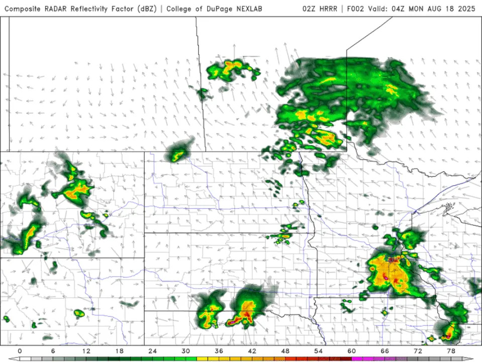
Looking at the HRRR model, more cells look set to pop up in central Minnesota and the metro area at around 3 a.m., before a large system enters southwestern Minnesota at around 4 a.m., arriving in the Twin Cities by about 8 a.m.
So it could be wet and wild commute for Minnesotans on Monday morning, with the for nonstop rain between 4 a.m. and 10 a.m. in the metro area, with the time period shifted a few hours earlier for southern and southwestern Minnesota.
10:35 p.m. Flash flood warning in Faribault, Red Wing
10:20 p.m. Urban flooding in Twin Cities till midnight
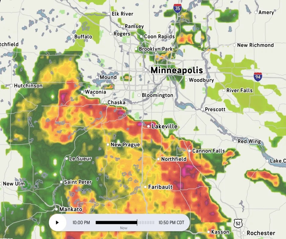
The NWS says the current heavy rain in the seven-county Twin Cities metro will result in urban and small stream flooding until midnight.
"A slow moving line of thunderstorms is producing heavy rainfall rates of around 2 inches per hour as it moves northeastward across the region," it reads. "Localized flooding may occur, especially in low-lying areas. Avoid driving or walking into flooded areas."
9:50 p.m. Special weather statement for Twin Cities
The next system arriving in the Twin Cities doesn't appear severe, with the NWS issuing a "special weather statement" rather than a severe thunderstorm warning.
The current statement covers Eden Prairie, Minnetonka and Edina, among other suburbs, and 40 mph wind gusts are possible.
9:40 p.m. Flash flood warning in Owatonna area
A flash flooding warning has gone into effect in southern Minnesota, affecting the Owatonna, Blooming Prairie, and Waseca area, until 2:30 a.m.
Those area have seen some extremely heavy rain over the past few hours, so it's possible more flood warnings are issued as the system moves northeast.
9:30 p.m. Heavy rain falling in Twin Cities, with more to follow
Bursts of heavy rain, the apparent remnants of the severe cell that spared a warning in the southwest metro, are currently making their way through Minneapolis and other west-metro cities.
What's more, they're an appetizer for the arrival of the larger system that's pushing it's way northeast currently, and per Accuweather should be arriving in the south Twin Cities by around 10 p.m.
Here's how Accuweather predicts the situation at 10 p.m.
9:05 p.m. Severe thunderstorm warning in Twin Cities
The southwest Twin Cities metro is included in the severe thunderstorm warning just issued by the NWS, with Prior Lake and Savage among the cities at risk from 60 mph winds.
8:45 p.m. Flash flooding potential very real
Here's acclaimed Minnesota meteorologist Paul Douglas on the sheer scale of the rain facing parts of Minnesota with tonight's rains.
8:25 p.m. Severe thunderstorm warning in Mankato
Up to 60 mph winds and pea-sized hail is possible in the Mankato area.
Here's some footage of the storm rolling in.
8:00 p.m. View from tornado-warned Waldorf
Minnesota storm chaser Tanner Charles posted this image showing the skies near Waldorf, which is currently under a tornado warning.
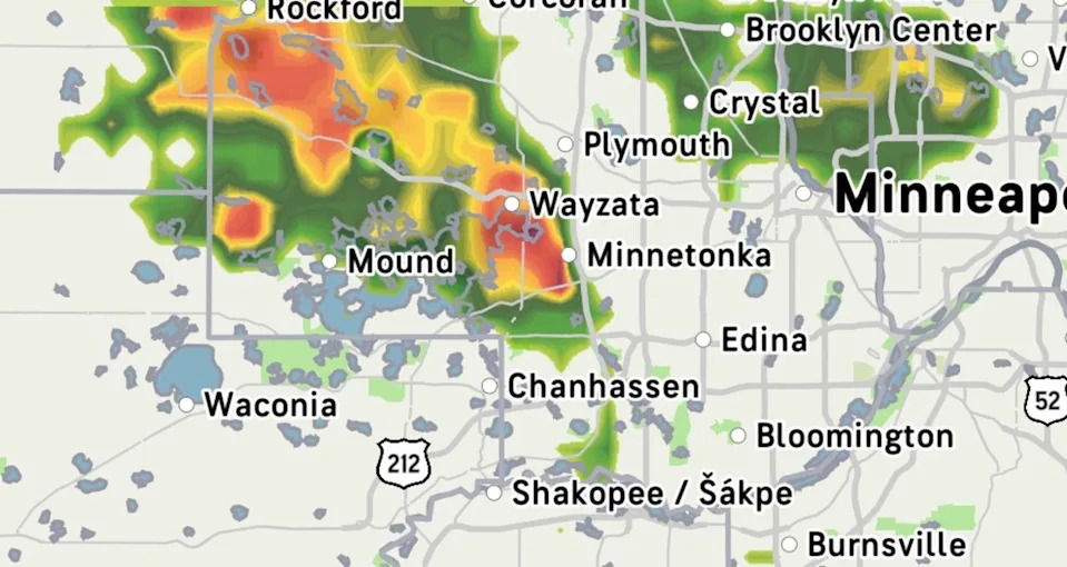
7:50 p.m. Heavy rain arrives in Twin Cities
A pocket of heavy rain has just passed over Lake Minnetonka and is making its way northeast. Another line appears to be forming behind it and will follow a similar track.
7:35 p.m. Severe thunderstorm warnings start
The system that is expected to drop several inches of rain tonight is now turning severe, with 60 mph wind gusts possible in the St. James, Madelia and Butterfield area until 8:15 p.m.
Another tornado warning has now been issued for Faribault and Waseca counties, with Minnesota Lake, Waldorf, and Easton under threat.
7:20 p.m. Tornado warnings in southern Minnesota
Radar-indicated tornado warnings have been issued in southern Minnesota, impacting the Frost, Minnesota, area until 7:30 p.m., and the Winnebago area until 8 p.m.
6 p.m. – Flash flooding potential
Officials say that flash flooding is a serious possibility, saying: "Soils, and local streams & creeks are already saturated after heavy rains since Friday, so any rainfall tonight could quickly begin to runoff and lead to flooding."
The Twin Cities metro was hit by up to 4 inches of rain between separate storms on Friday and Saturday, while southern Minnesota saw more than 4 inches of rain from a stalled storm system early Sunday morning.
"Excessive runoff may result in flooding of rivers, creeks, streams, and other low-lying and flood-prone locations," the flood watch advisory. "Area creeks and streams are running high and could flood with more heavy rain."
In its forecast discussion, the NWS Twin Cities says the storm will be moving at 20-25 mph or less, with rain falling at rates of 2-inches per hour in the hardest hit areas.
As of Sunday afternoon there was still uncertainty over where the heaviest rain will happen, but the NWS forecast discussion says "nearly all high-resolution models depict localized amounts of 4+ where they have the heaviest thunderstorms."
"This leads to higher confidence in the potential for heavy rain and flooding tonight, even if we wont know exactly where until storms fire this evening," it adds.
It's also possible that some of the storms making their way through the state on Sunday turn severe, with damaging wind gusts the primary hazards, but hail also possible.
This story was originally reported by Bring Me The News on Aug 18, 2025, where it first appeared.


Comments