If you're making plans to head to Tidewater Virginia this week, you might want to think twice about getting anywhere near the Atlantic Ocean because Hurricane Erin will make its northward turn and is expected to lash the Mid-Atlantic coastline with dangerous rip currents and surf conditions.
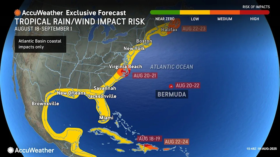
Erin, currently a Category 4 storm with maximum winds of 140 mph, is not expected to make landfall. But weather forecasters are predicting that the storm will pass close enough to the United States to churn rough oceanfront conditions from Miami northward to Canada.
Erin was about 800 miles south-southeast of Cape Hatteras, North Carolina midday Aug. 18. It was moving west-northwest but is expected to take its northerly turn Aug. 19.
The National Weather Service office in Wakefield issued a Beach Hazards statement for all beaches in Virginia and Maryland from 8 a.m.-8 p.m. Aug 18.
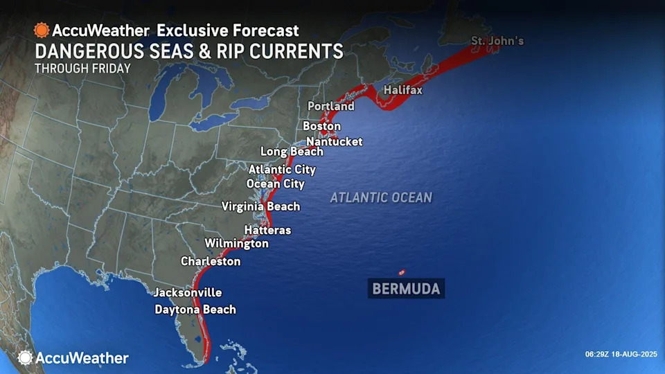
"Breaking waves of 3-5 feet and long wave periods will result in rough surf conditions and a high risk of rip currents," NWS Wakefield said. "Remain out of the water to avoid hazardous swimming conditions."
How Hurricane Erin will impact East Coast
AccuWeather lead hurricane expert Alex DaSilva said in an interview that those conditions are basically the appetizer for the main course that will come later in the week.
"The rip current risk starts Tuesday and the big waves start Thursday morning," DaSilva said. "The waves are going to be around through Saturday, at least through the weekend. There could still be some rip currents on Saturday."
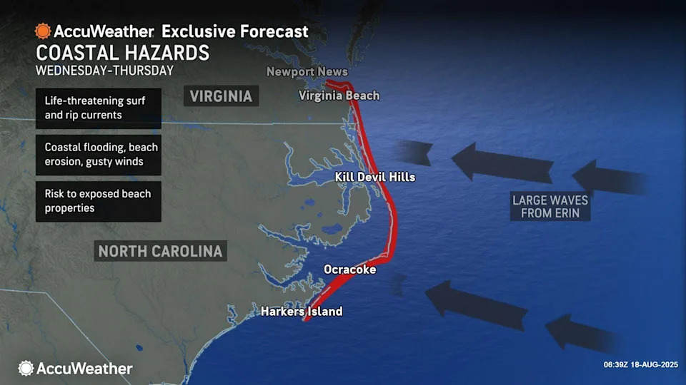
DaSilva said don't be surprised to see potential waves of 15 feet, although they are likely to be closer to 10 feet. That will depend on just how close Erin comes to clipping the East Coast. In addition to the waves, he said, Virginia Beach could see storm surges of 1-3 feet.
"I think in those areas there and right on the Atlantic is going to have the biggest waves, some storm surge, coastal flooding issues," he said. "But even areas inland, a little bit like Newport News that's kind of more sheltered, they're still going to see some some waves and into the Chesapeake [Bay]. So there's still going to be stuff that kind of funnels in there a little bit. Worst will be on the Atlantic."
Newport News is about 40 miles from the Virginia Beach oceanfront. For points westward from there, like central Virginia and the Shenandoah Valley, Erin is not likely to be much of a threat.
Will Hurricane Erin threaten inland areas?
"I don't think any rain from the storm even gets back to Richmond," Da Silva said. "I don't think really anything gets too far west of Newport News for rain. The rain is going to be pretty light; it should be under an inch. Even if the storm comes west a little bit, the rain is not going to be the story here. It's going to be the waves and the coastal flooding."
NWS forecasts for inland Virginia seem to bear that out. In central and Shenandoah Virginia, for example, predictions call for partly to mostly sunny skies with just the typical summertime threat of heat-spawned thunderstorms.
However, DaSilva warns inland Virginia to not get too complacent. Some patterns have Erin swinging out more to the west than predicted.
"We don't expect a landfall. We don't expect this to, like, hit the Outer Banks, but it could come much closer than what is currently forecasted just because of the Western shift," he said. "We've seen the trends to the west. So if that were to occur, the impacts could be a little bit more. But for now, what I listed off to seems like it's the most likely scenario."
In the tourist-popular Outer Banks of North Carolina, they are taking no chances. The state has issued a mandatory evacuation for Hatteras Island in Dare County. Slightly north of there in Nags Head, Kill Devil Hills and Kitty Hawk, there are no mandatory get-out orders, but the entirety of Dare County has declared a state of emergency.
Prime time to hang 10 during Hurricane Erin?

The news of Erin's churn is not all bad, at least for those who love to surf.
The online forecaster Surf Captain expects waves to be as high as 5-8 feet on Aug. 19, peaking at 8-12 feet on Aug. 21. Those waves, however, are expected to be choppy.
By Friday, Aug. 22, Surf Captain predicts waves to be back down to 4-6 feet.
Erin is the first hurricane to form this Atlantic season and the first to become a major storm. There have been reports of widespread damage among Turks & Caicos, Puerto Rico and the Bahamas, all of whom were within the storm's main path.
This article originally appeared on Staunton News Leader: Hurricane Erin forecast, track, landfall and impact in Virginia


Comments