Hurricane Erin was on a path to head up the Atlantic Ocean and likely bring "life-threatening surf and rip currents" across the U.S. East Coast this week, the National Hurricane Center in Miami said Monday. The hurricane wasn't expected to make landfall in the U.S., but people in North Carolina's Outer Banks were warned of possible coastal flooding that triggered evacuation orders.
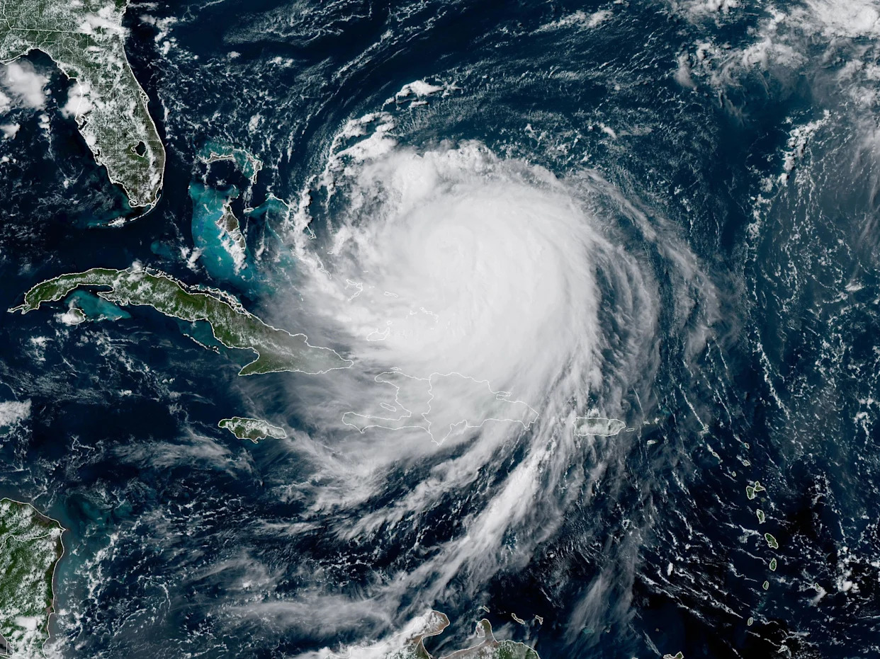
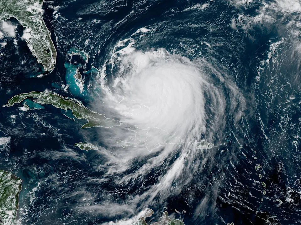
Erin, the first Atlantic hurricane of 2025, weakened back into a Category 3 storm late Monday night as it churned over the Atlantic Ocean north of the Caribbean. It previously exploded to a Category 5 on Saturday before weakening to a Category 3 early Sunday morning, then regaining strength again later in the day.
As of 11 p.m. ET Monday, Erin had maximum sustained winds of 125 mph. The storm's center was about 690 miles southwest of Bermuda and about 780 miles south-southeast of Cape Hatteras, North Carolina. It was moving northwest at 8 mph. A Category 3 hurricane is defined as having maximum sustained winds from 111-129 mph and is considered a major storm, capable of causing catastrophic damage.
Maps show Hurricane Erin's forecast path
Erin is a large storm that's expected to remain powerful for the next several days, forecasters said.
The center of the storm was expected to turn to the north on Tuesday and move between Bermuda and the U.S. East Coast by the middle of the week, the hurricane center said.
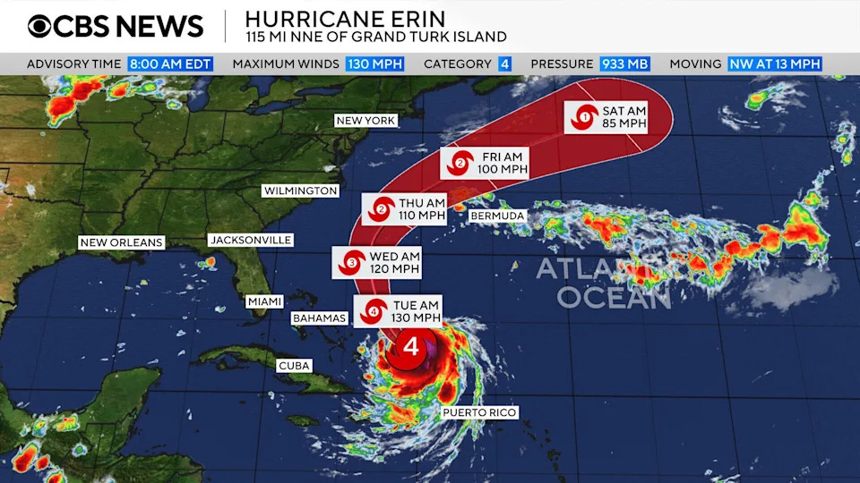
Forecasters warned that Erin was likely to remain a "dangerous major hurricane" through the middle of the week but not much additional strengthening was expected.
Erin's hurricane-force winds extended outward up to 80 miles from the center and tropical storm-force winds extended up to 230 miles from the center, forecasters said.
Tropical storm warnings were in effect for Turks and Caicos and the southeast Bahamas, the hurricane center said. Tropical storm watches were issued for the central Bahamas and North Carolina's Outer Banks. A tropical storm warning means tropical storm conditions are expected somewhere within the warning area, while a watch means they are possible.
A storm surge watch was also issued for the Outer Banks, alerting people to the possibility of life-threatening inundation from coastal flooding starting Wednesday.
Hurricane Erin's "spaghetti models"
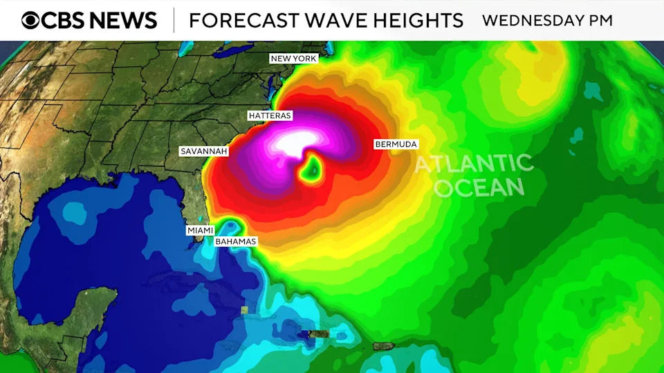
A "spaghetti map" of the forecast models shows the storm skirting the Caribbean islands and remaining well offshore of the U.S. East Coast as it moves north and curves back over the Atlantic.

A high-pressure system in the Atlantic was expected to steer Erin away from the U.S. coast while a cold front was also forecast to push the hurricane offshore, CBS News Bay Area meteorologist Jessica Burch reported.
How will Hurricane Erin affect the U.S.?
Erin is not forecast to hit the U.S. directly, but coastal areas along the Eastern Seaboard will feel its effects with dangerous rip currents and high waves of more than 20 feet over the next several days.
"These rough ocean conditions will likely cause life-threatening surf and rip currents," the hurricane center warned.
Mike Brennan, the hurricane center's director, said the dangerous conditions were expected to last for much of the week across almost the entire East Coast. He urged people to heed any warnings from local officials.
"It's just not going to be a very safe environment to be in the ocean," Brennan said Monday.
The Outer Banks, in particular, should monitor the progress of Erin, the hurricane center advised, noting that in addition to rip currents, there is a risk of strong winds associated with the outer rainbands during the middle part of the week. Mandatory evacuations were ordered for Hatteras Island and Ocracoke Island.
Along the Outer Banks, the National Weather Service warned of the potential for severe flooding to reach buildings and roads. Many roadways will likely be under several feet of water and inaccessible for several days due to the flooding.
First hurricane of the Atlantic season
Erin formed as a tropical storm last week west of the island nation of Cabo Verde, a few hundred miles off Africa's western coast. It is the fifth named storm of the 2025 Atlantic hurricane season, which started in June and runs through November. Erin strengthened to a hurricane on Friday.
So far this year, Tropical Storm Chantal is the only one to have made landfall in the U.S., bringing deadly flooding to North Carolina in early July. In June, Barry made landfall as a tropical depression on Mexico's eastern coast.
Erin's increased strength comes as the Atlantic hurricane season approaches its peak in September. According to the hurricane center, most of the season's activity typically happens between mid-August and mid-October. In the eastern Pacific Ocean, hurricane season starts on May 15 with a peak in activity typically seen in late August.

The U.S. National Oceanic and Atmospheric Administration, or NOAA, forecast an above-normal season for the Atlantic this year, expecting between 13 and 18 named storms.
Tropical storms have maximum sustained winds of at least 39 mph. Forecasters with NOAA anticipated that between five and nine of the storms this year could become hurricanes, which have sustained winds of at least 74 mph. Hurricanes are rated on a scale based on their wind speeds, ranging from Category 1, the weakest, to Category 5, the most severe rating.
NOAA forecasters predicted there could be between two and five major hurricanes in the Atlantic this season.
Alaska Sen. Dan Sullivan on the Trump-Putin summit, sanctions and more


Comments