Hurricane Erin formed early Friday, Aug. 15, marking the first hurricane of the 2025 Atlantic hurricane season before exploding overnight and strengthening into a Category 5 storm by afternoon Saturday, Aug. 16.
Erin is the fifth named storm of what forecasters predicted would be an above-average season. But more notably, it is only the fifth hurricane on record to reach Category 5 strength this early — and the first to do so outside the Gulf or Caribbean, according to WPLG-TV hurricane specialist Michael Lowry.
The system strengthened to sustained winds of 160 mph, but later that day an eyewall replacement cycle caused Erin to weaken slightly.
As of Monday, Aug. 18, it remains at Category 4 status.
➤ Weather alerts via text: Sign up to get updates about current storms and weather events by location
➤ Don't have a hurricane supply kit? From the basics to the extras, here's what you need
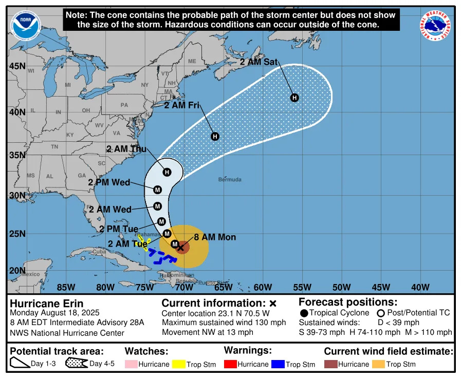
Where is Hurricane Erin going?
While Hurricane Erin is not expected to make landfall on the U.S. and is forecast to dissipate in the open Atlantic by early Saturday, Aug. 23, dangerous and life-threatening rip and surf currents are predicted along the East Coast from Florida through Maine this week.
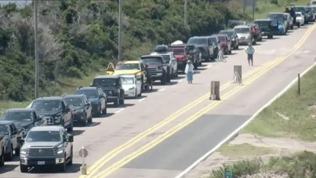
The storm’s rapid intensification has prompted increased emergency measures in North Carolina, and the Outer Banks — a popular summer vacation spot — are now under a state of emergency. Officials mandated evacuations for Hatteras Island, ordering visitors to leave by 10 a.m. Monday, Aug. 18, and residents by 8 a.m. Tuesday, Aug. 19, as forecasters warned of life-threatening rip currents, large swells, coastal flooding and road washouts.
More: NC declares state of emergency in Outer Banks as Hurricane Erin shifts north. See tracker
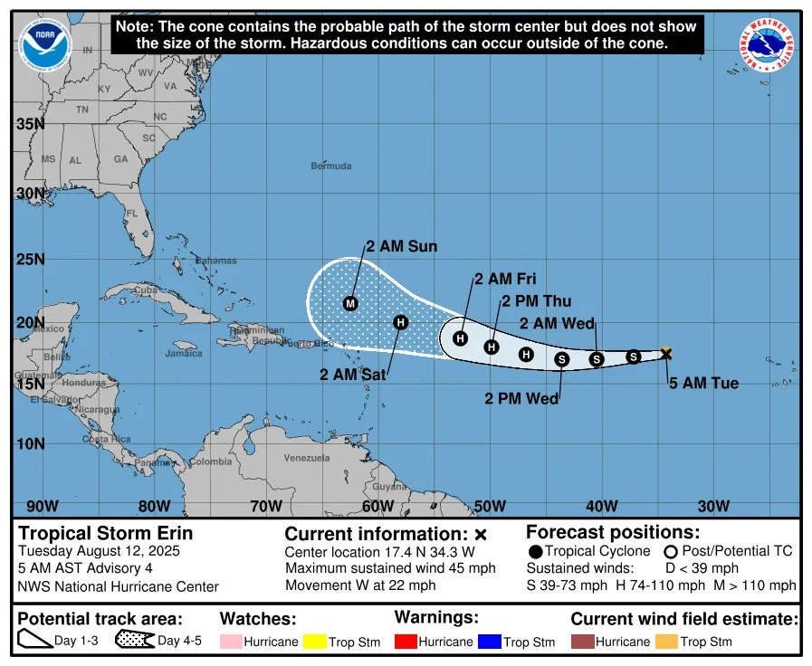
Special note on the NHC cone: The forecast track shows the most likely path of the center of the storm. It does not illustrate the full width of the storm or its impacts, and the center of the storm is likely to travel outside the cone up to 33% of the time.
Hurricane Erin spaghetti models
Special note about spaghetti models: Illustrations include an array of forecast tools and models, and not all are created equal. The hurricane center uses only the top four or five highest performing models to help make its forecasts.
Hurricane Erin storm tracker, path
Satellite view of Hurricane Erin
Track all active Atlantic storms and disturbances
North Carolina weather radar for Aug. 18, 2025
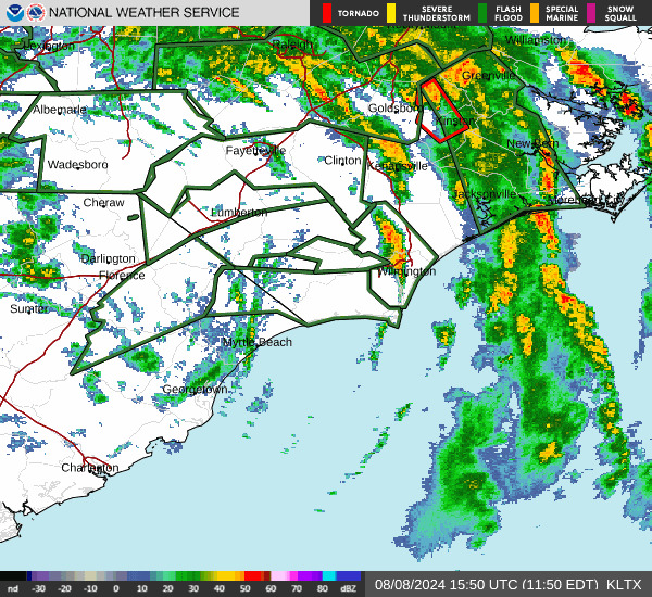
Weather watches and warnings issued in North Carolina
When is the Atlantic hurricane season?
The Atlantic hurricane season runs from June 1 through Nov. 30.
Ninety-seven percent of tropical cyclone activity occurs during this time period, NOAA said.
The Atlantic basin includes the northern Atlantic Ocean, Caribbean Sea and Gulf of America, as the Gulf of Mexico is now known in the U.S. per an order from President Trump. NOAA and the National Hurricane Center are now using Gulf of America on its maps and in its advisories.
When is the peak of hurricane season?
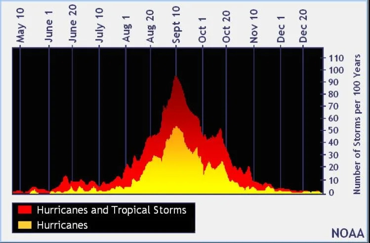
The peak of the season is Sept. 10, with the most activity happening between mid-August and mid-October, according to the Hurricane Center.
Hurricane names for 2025 season
Here are the names for the 2025 Atlantic hurricane season, along with how to pronounce them:
Andrea(June 20)Barry(June 29)Chantal(July 5)Dexter(Aug. 3)Erin: AIR-rin (Tropical storm: Aug. 11; Hurricane: Aug. 15; Major hurricane Aug. 16)
Fernand: fair-NAHN
Gabrielle: ga-bree-ELL
Humberto: oom-BAIR-toh
Imelda: ee-MEHL-dah
Jerry: JEHR-ee
Karen: KAIR-ren
Lorenzo: loh-REN-zoh
Melissa: meh-LIH-suh
Nestor: NES-tor
Olga: OAL-guh
Pablo: PAHB-lo
Rebekah: reh-BEH-kuh
Sebastien: se-BAS-tee-en
Tanya: TAHN-yuh
Van: van
Wendy: WEN-dee
Interactive map: Hurricanes, tropical storms that have passed near your city
Stay informed. Get weather alerts via text
What's next?
We will update our tropical weather coverage daily.
Download your local site's app to ensure you're always connected to the news. And look for our special subscription offers here.
This story has been updated to include new information.
This article originally appeared on Asheville Citizen Times: Hurricane Erin risks in NC grow. See spaghetti models, path, tracker


Comments