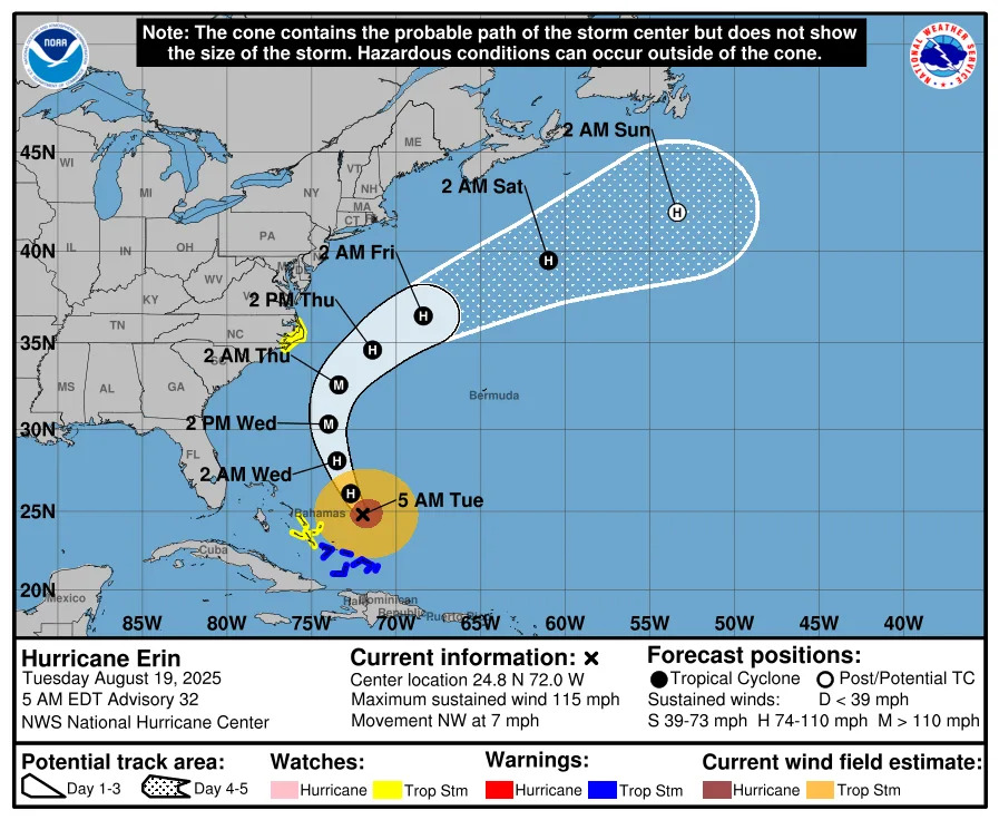
Hurricane Erin weakened to a category 3 hurricane during the early hours of Aug. 19 as it moves closer to the East Coast, according to the National Hurricane Center.
As of 5 a.m. Aug. 19, Erin was located 675 miles southwest of Bermuda and 750 miles from Cape Hatteras, North Carolina. It has sustained winds of 115 mph and is moving northwest at 10 mph. It will start making its turn north on Aug. 19.
The center of Erin will pass to the east of the Bahamas on Aug. 19 and 20 and then move over the western Atlantic between the East Coast and Bermuda on Aug. 20 and 21.
How will Hurricane Erin impact the East Coast, Delaware?
Big waves and rough surf are expected along the Atlantic Coast from Central Florida to Canada as powerful and massive Hurricane Erin begins its slow cruise northward hundreds of miles offshore.
Erin is expected to grow in size throughout the weeks with dangerous rip currents along East Coast Beaches.
A coastal flood advisory is in effect for the Delaware beaches through at least 10 p.m. Aug. 18, with up to a foot of inundation above ground level expected in low-lying areas near shorelines and tidal waterways, according to the National Weather Service.
Evacuations were underway along parts of North Carolina's Outer Banks ahead of an expected storm surge and waves of over 10 feet, and the National Weather Service was urging people to stay out of the ocean to avoid the deadly surf conditions expected through at least Thursday. Officials in Dare County warned that roads, including the main exit route, would soon be overwhelmed by water.
"Dare County remains under a State of Emergency and a Mandatory Evacuation order is in effect for Hatteras Island," the county posted on social media. "Please note that N.C. Hwy. 12 may be impassable by August 19 at 5 p.m."
In neighboring Hyde County, a mandatory evacuation order went into effect on Aug. 19 for Ocracoke Island.
When is Hurricane Erin supposed to hit Delaware?
While the storm is not expected to make landfall, dangerous rip currents and breaking waves are forecast from East Central Florida to Canada's Atlantic Coast beginning Aug. 19, Hurricane Center Director Michael Brennan has warned.
Brennan is pleading with U.S. residents to take Erin's potential coastal impacts seriously, even though the nation will be spared a direct landfall. Offshore wave heights could exceed 20 to 30 feet.
High tides are also expected to bring higher-than-normal water levels further southward along the coast, the weather service has warned.
"It's not going to be a safe environment to be in the ocean," Brennan said, adding that even when the weather may be pleasant on shore, dangerous and possibly life-threatening rip currents could be lurking in the water.
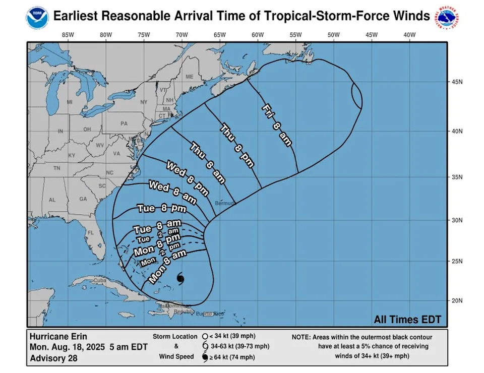
Delaware can expect to start feeling tropical storm-force winds by Aug. 20.
Dewey Beach closes for Hurricane Erin
Dewey Beach closed ocean access around 12:30 p.m. Aug. 18 "due to rip currents and dangerous waves," the town's website said. In Rehoboth Beach, officials prohibited swimming around the same time. You can still walk on both beaches.
Dewey is seeing 20 to 25 mph sustained winds and 4-to-6-foot swells, Town Manager Bill Zolper said.
"We've got a real bad cut on the beach, it drops off about four feet. The wind is driving so hard out of the northeast it drives the waves against the sand and cuts the beach out," Zolper said. "It's only gonna get worse as the night goes on."
What are Hurricane Erin's spaghetti models?
Special note about spaghetti models: Illustrations include an array of forecast tools and models, and not all are created equal. The hurricane center uses only the top four or five highest performing models to help make its forecasts.
What's next behind Hurricane Erin?
Following behind Erin is yet another tropical wave that's given a 60% chance of becoming a tropical storm over the next seven days, the hurricane center said. A third disturbance just moved off the West African coast, but it's expected to encounter hostile conditions that may limit its further development.
What is a rip current?
According to NOAA, rip currents are channeled currents of water that flow away from the shore out past the line of breaking waves. They form from water piling up between the breaking waves and the beach. As the water returns from the shore, it forms a narrow stream of water that moves quickly out to sea.
What to do in a rip current
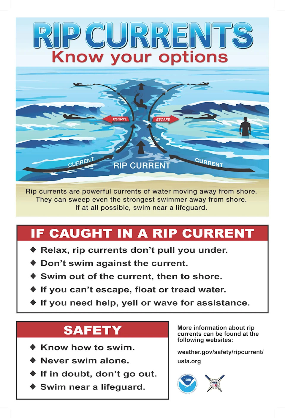
According to the United States Lifesaving Association, swimmers should do the following:
Relax, rip currents don't pull you under.
Don’t swim against the current.
You may be able to escape by swimming out of the current in a direction following the shoreline, or toward breaking waves, then at an angle toward the beach.
You may be able to escape by floating or treading water if the current circulates back toward shore.
If you feel you will be unable to reach shore, draw attention to yourself. If you need help, yell and wave for assistance.
When is hurricane season?
Hurricane season runs from June 1 through Nov. 30. However, hurricanes can occur before and after those dates.
What are the categories for tropical cyclones and hurricanes?
Tropical storm
A tropical storm is a tropical cyclone with winds between 39 and 73 mph. These storms bring heavy rains that could lead to dangerous flooding.
Category 1
A category 1 storm is the weakest of the hurricanes with winds between 74 and 95 mph. The storm will cause some flooding, but no real structural damage.
Category 2
A category 2 storm has winds between 96 and 110 mph. The storm can cause moderate damage to buildings.
Category 3
A category 3 storm will have winds from 111-129 mph. It can cause major damage to well-built framed homes, uproot trees and cause power and communication outages.
Category 4
A category 4 storm can cause catastrophic damage to well-built framed homes, tearing off roofs and breaking exterior walls. Mobile homes are destroyed. Roads are impassible and there are communication and power outages.
Category 5
A category 5 storm can cause catastrophic damage with most framed homes and mobile homes being destroyed. Trees will be snapped and uprooted. Roads will be impassible and there will be extended power and communication outages.
This article originally appeared on Delaware News Journal: Hurricane Erin tracker: Latest forecast category 3 storm, spaghetti models


Comments