The Brief
Central Florida faces extreme heat today with feels-like temps up to 115°, prompting a warning from 12–7 p.m.
Scattered storms are likely this afternoon and evening.
More daily storms are expected later this week as high pressure shifts.
ORLANDO, Fla. - Tuesday is a FOX 35 Weather Impact Day as we prepare for another day of dangerously hot temperatures across Central Florida.
Here's what you need to know about today's forecast.
Dangerous heat wave
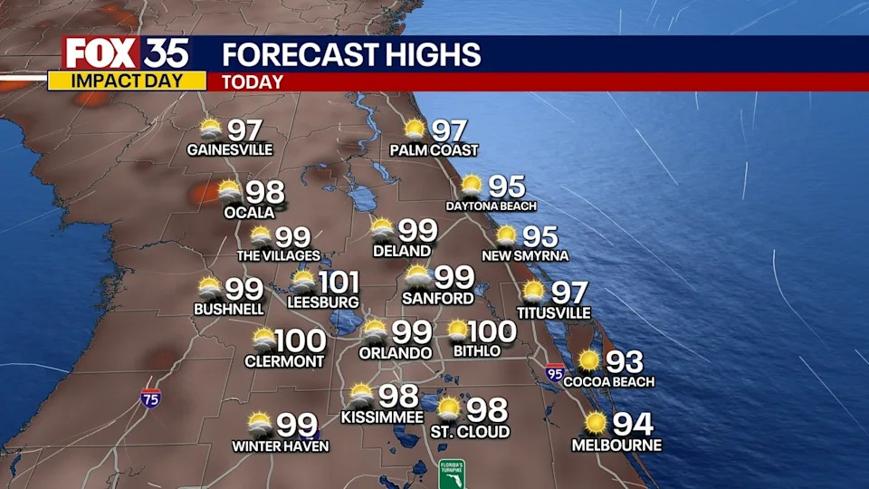
What to expect
Temperatures will be approaching dangerous levels this afternoon across Central Florida. Highs will be a degree or two either side of 100° for inland areas, and closer to the mid-90s along the coast.
CLICK TO DOWNLOAD THE FOX LOCAL APP
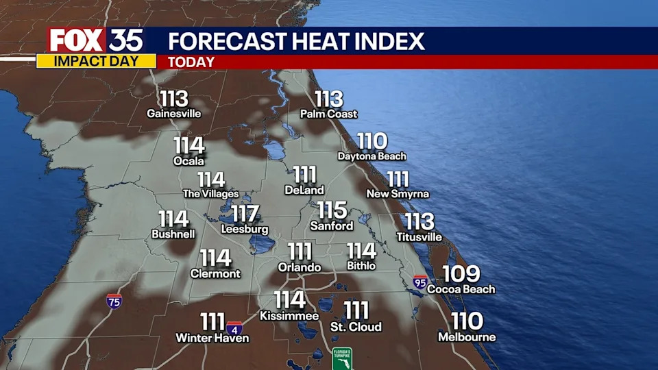
Once we factor in the humidity, temperatures will feel much hotter. Plan for heat indices that will top out at 110-115°+.
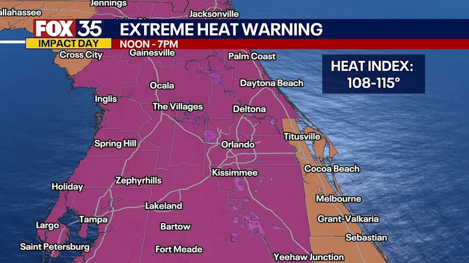
Extreme Heat Warning Today
This is why an Extreme Heat Warning has been issued for nearly the entire region from 12pm-7pm. This will be the window of time when we expect the hottest and most uncomfortable of temperatures to take shape.
Extreme Heat Warning vs. Heat Advisory: What's the difference?
Dig deeper
According to the National Weather Service, an Extreme Heat Warning is issued when dangerously high heat and humidity pose a severe risk of heat-related illnesses, often with heat index values exceeding 105°F for several hours.
A Heat Advisory, however, is issued for less intense heat conditions that still pose a risk but are generally less severe than those warranting an Extreme Heat Warning.
Extreme Heat Warning Map
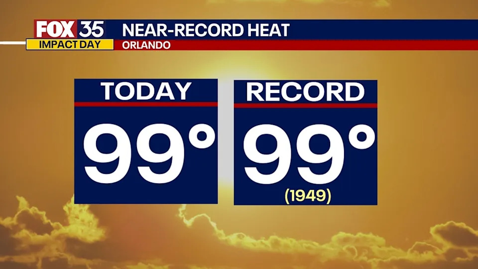
Today's high of 99° in Orlando would tie the previous record of 99° set back in 1949.
Will it rain?
Scattered afternoon and evening storms will be likely today as well, at a 40% chance. Some of these could pack a bit of a punch with heavy rain, gusty winds, and frequent lightning. The best chances of rain will be from 2pm-9pm.
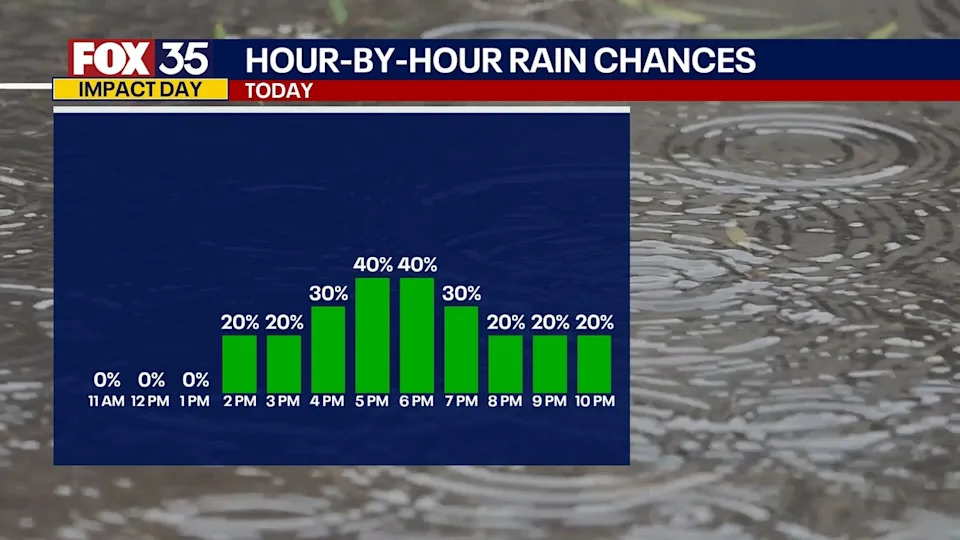
Any lingering showers will fade overnight. We stay warm and muggy with lows falling into the upper 70s and low 80s.
What will the weather look like for the remainder of the week?
Looking ahead
The large dome of high pressure, which has been the culprit behind our intense heat, will shift gradually to the west in the coming days. This will allow sea-breeze showers and storms to set back up, meaning daily rounds of afternoon showers and storms will become more likely.
Temperatures, however, will stay above average as highs soar into the mid-90s.
There is the potential of a front to stall out over north sections of Florida, which could bring added rounds of showers and storms late this weekend and into early next week.
SIGN-UP FOR FOX 35'S BREAKING NEWS, DAILY NEWS NEWSLETTERS
Tracking the Tropics
In the Atlantic, there's no tropical development expected over the next seven days, per the National Hurricane Center (NHC).
We're still monitoring the few tropical waves that are across the Atlantic. What was a more prominent wave near the west coast of Africa yesterday has fallen apart quite a bit over the last 12 hours.
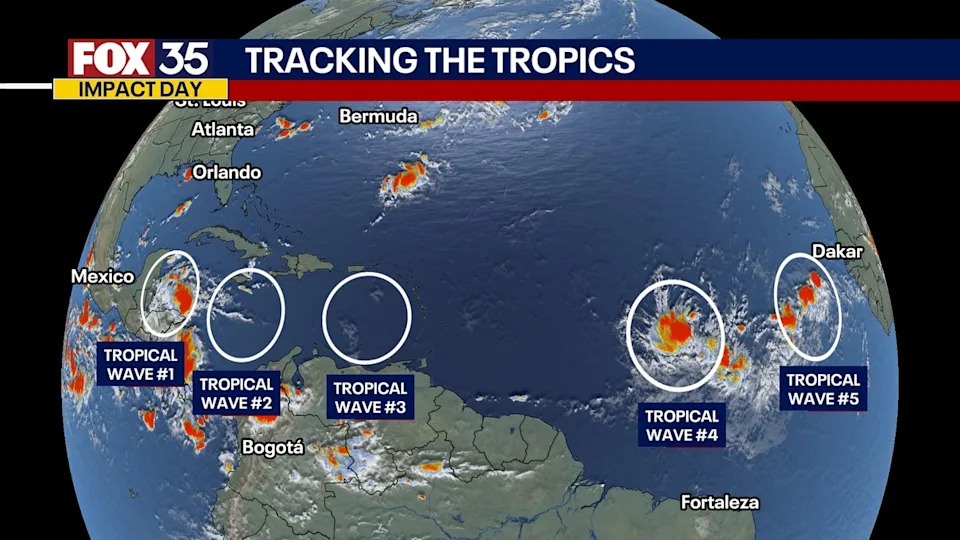
There are a few more waves, one near the south central Atlantic, and a few more near South America and the Caribbean Sea. The chance of these waves becoming a more organized system is quite low.
A large plume of Saharan Dust along with wind shear will help limit development for any system for at least the next week.
There are no areas of concern at this time and there are no impacts to Florida.
The Source
This story was written based on information shared by the FOX 35 Storm Team on July 29, 2025.


Comments