Short on time? We also have a quick guide with everything you need to know about Hurricane Erin. Read the brief explainer here.
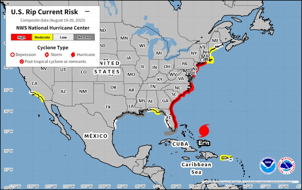
Hurricane Erin fluctuated in intensity on Monday and expanded in size as people fled North Carolina's Outer Banks and forecasters warned of "life-threatening" rip currents and surf conditions along most of the East Coast.
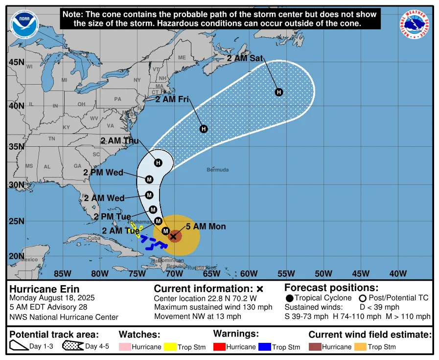
After losing some intensity over the weekend, Erin briefly strengthened back into a Category 4 storm with maximum sustained winds of 130 mph. But by an 11 p.m. advisory from the National Hurricane Center, its winds had fallen to an estimated 125 mph after its north side encountered shearing winds. The forecast indicated Erin is slowing down in forward speed and may continue to see fluctuating wind speeds over the next couple of days as it gradually turns northward along a track between the United States and Bermuda.
Dozens of rip current rescues have already been made along the North Carolina and South Carolina coasts, despite the storm still being far offshore. Local beaches are urging visitors not to swim until Friday, Aug. 22, due to dangerous conditions. It's also important to note that this warning doesn’t account for the potential contaminants and debris that could wash ashore once Hurricane Erin passes, which may take days to clear.
Erin is the fifth named storm of what forecasters predicted would be an above-average season. But more notably, it is only the fifth hurricane on record to reach Category 5 strength this early — and the first to do so outside the Gulf or Caribbean, according to WPLG-TV hurricane specialist Michael Lowry.
➤ Weather alerts via text: Sign up to get updates about current storms and weather events by location
Will Hurricane Erin hit South Carolina?
Hurricane Erin is not expected to make landfall on the U.S. and is forecast to dissipate in the open Atlantic by early Saturday, Aug. 23.
Still, Erin's large and expanding wind fields mean storm-driven waves, coastal erosion, and high seas are expected to batter areas of the coast, especially along North Carolina's Outer Banks.
In an advisory Monday, Aug. 18,, National Hurricane Center Director Michael Brennan said "breaking waves of 15 to 20 feet plus coastal flooding and storm surge could over wash dunes and flood homes and flood roads and make some communities impassable."
“These are going to be situations where you’re not going to want to be in the ocean, and you're going to want to heed any precautions given by your local officials,” he said. “Even though the weather can be nice at the coast, it can still have dangerous surf and rip current conditions from a hurricane that's well offshore like we're going to Erin.”
The storm’s rapid intensification has prompted increased emergency measures in North Carolina, and the Outer Banks — a popular summer vacation spot — are now under a state of emergency. Officials mandated evacuations for Hatteras Island, Ockracoke and Currituck County, residents to leave by 8 a.m. Tuesday, Aug. 19, as forecasters warned of life-threatening rip currents, large swells, coastal flooding and road washouts.
Where is Hurricane Erin headed? See path
Special note on the NHC cone: The forecast track shows the most likely path of the center of the storm. It does not illustrate the full width of the storm or its impacts, and the center of the storm is likely to travel outside the cone up to 33% of the time.
Here's the latest Aug. 19 update on Hurricane Erin.
Location: 720 miles south-southeast of Cape Hatteras North Carolina
Maximum sustained winds: 110 mph
Movement: northwest at 7 mph
Pressure: 958 mb
Where is Hurricane Erin headed? See projected path
Hurricane Erin spaghetti models
Special note about spaghetti models: Illustrations include an array of forecast tools and models, and not all are created equal. The hurricane center uses only the top four or five highest performing models to help make its forecasts.
Watch: Update on Major Hurricane Erin from the National Hurricane Center
When is the Atlantic hurricane season?
The Atlantic hurricane season runs from June 1 through Nov. 30.
Ninety-seven percent of tropical cyclone activity occurs during this time period, NOAA said. The season peaks in August and September.
The Atlantic basin includes the northern Atlantic Ocean, Caribbean Sea and Gulf of America, as the Gulf of Mexico is now known in the U.S. per an order from President Trump. NOAA and the National Hurricane Center are now using Gulf of America on its maps and in its advisories.
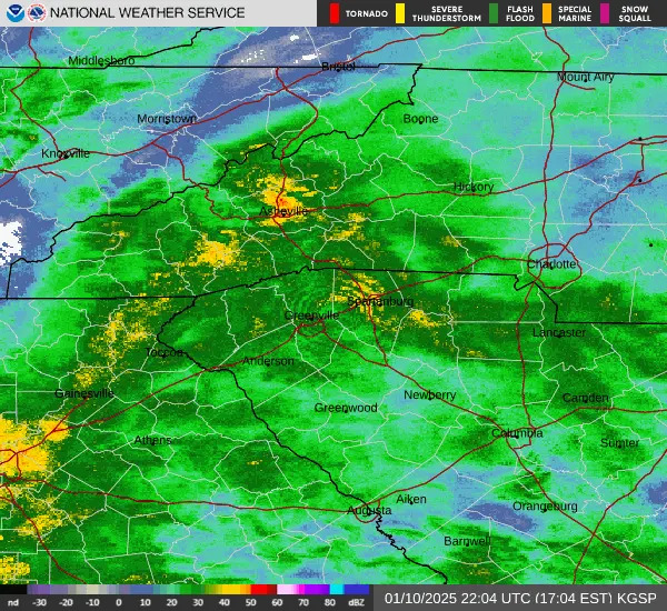
South Carolina weather radar
Stay informed. Get weather alerts via text
Brandi D. Addison covers weather across the United States as the Weather Connect Reporter for the USA TODAY Network. She can be reached at [email protected].
This article originally appeared on Greenville News: When will Hurricane Erin pass by SC? Projected paths, models


Comments