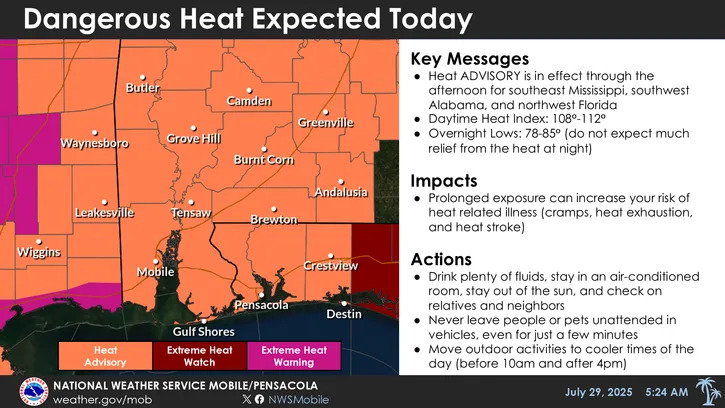
Tuesday will be another scorcher as the National Weather Service expects heat indices in the Florida Panhandle to reach 109℉.
The NWS office in Mobile, Alabama, issued another heat advisory for Escambia, Santa Rosa and Okaloosa counties in effect from 10 a.m. to 6 p.m.
It's the second heat advisory of the week, after Monday's high temperatures peaked around 97℉, with heat index values reaching 111℉, according to NWS data.
Monday's heat broke the average temperature daily record. The average temperature hit 87.5℉, which is 4℉ higher than the normal. High temperatures on Monday hit 97℉, which was 5℉ higher than the daily average and nearly matched the 98℉ daily record high set in 1993.
What is a heat advisory? What to know about heat alerts
The National Weather Service uses a three-tiered heat alert system. Not all local offices use every heat-related product due to some places being more prepared to deal with intense heat than others.
Here's a general rundown of what each heat alert means:
Extreme heat warning — Take action! An extreme heat warning is issued when extremely dangerous heat conditions are expected or occurring. Avoid outdoor activities, especially during the heat of the day. If you must be outside, be sure to drink plenty of water and take frequent breaks in the shade. Stay indoors in an air-conditioned space as much as possible, including overnight. Check on family and neighbors.
Extreme heat watch — Be prepared! An extreme heat watch is issued when conditions are favorable for an extreme heat event but its occurrence and timing is still uncertain. Plan to suspend all major outdoor activities if a warning is issued. If you do not have air conditioning, locate the nearest cooling shelter or discuss staying with nearby family or friends who have air conditioning.
Heat advisory — Take action! A heat advisory is issued for dangerous heat conditions that are not expected to reach warning criteria. Consider postponing or rescheduling outdoor activities, especially during the heat of the day. If you must be outside, be sure to drink plenty of water and take frequent breaks in the shade. Stay in a cool place, especially during the heat of the day and evening.
Has July been hotter than normal in Pensacola?
July has been a toasty one in Pensacola, with temperatures averaging 1.1℉ hotter across the month so far, according to NOAA's latest climate data.
Here's a look at July's stats so far:
Month-to-date summary | Observed | Normal | Record highest | Record lowest |
Avg. max temp | 92.2℉ | 91.6℉ | 95.6℉ in 2000 | 84℉ in 1916 |
Avg. min temp | 76.8℉ | 75.3℉ | 77.7℉ in 1932 | 71.1℉ in 1967 |
Avg. temp | 84.5℉ | 83.4℉ | 85.9℉ in 2000 | 78.4℉ in 1923 |
Total precipitation | 2.82 in. | 7.1 in. | 20.36 in. in 1979 | 0.18 in. in 2000 |
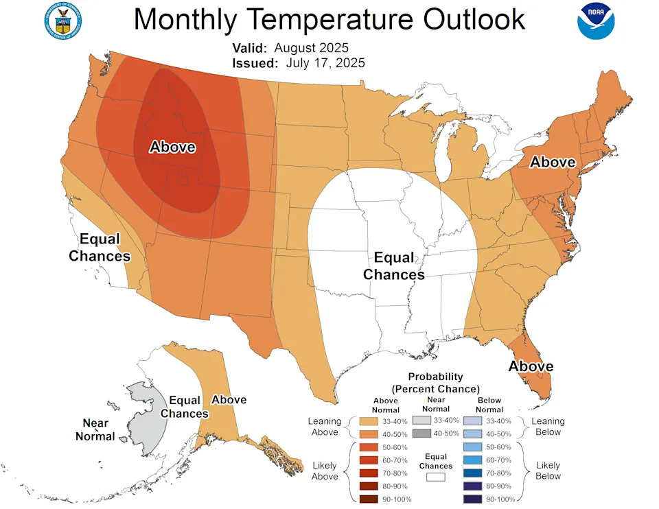
How hot will August be in Florida?
NOAA's Climate Prediction Center believes that the majority of Florida is likely to see above-normal temperatures in August. The Pensacola area stands out as the only part of the state that has equal chances of seeing below- or above-normal temperatures.
The map of areas impacted by the current heat dome is a near inversion of NOAA's monthly temperature map, which was issued on July 17. The odds could swing toward Pensacola seeing a warmer-than-normal August should the dome stick around.
Weather radar for Pensacola, Milton, Fort Walton Beach, Destin
Heat index alert: Weather watches and warnings issued in Florida
Pensacola 7-day weather forecast
Tuesday
Day forecast
High temperature: 95 degrees
Chance of rain: 58%
Detailed forecast: Showers and thunderstorms likely after 10 a.m. Mostly sunny. High near 95, with temperatures falling to around 90 in the afternoon. Heat index values as high as 107. West wind around 5 mph. New rainfall amounts between a tenth and quarter of an inch possible.
Night forecast
Low temperature: 81 degrees
Chance of rain: 60%
Detailed forecast: Showers and thunderstorms likely. Partly cloudy, with a low around 81. Northwest wind around 5 mph. New rainfall amounts between a tenth and quarter of an inch possible.
Wednesday
Day forecast
High temperature: 90 degrees
Chance of rain: 46%
Detailed forecast: A chance of showers and thunderstorms. Mostly sunny, with a high near 90. Heat index values as high as 105. Southwest wind 5 to 10 mph. New rainfall amounts between a tenth and quarter of an inch possible.
Night forecast
Low temperature: 82 degrees
Chance of rain: 46%
Detailed forecast: A chance of showers and thunderstorms before 7 p.m. Mostly clear, with a low around 82. Southwest wind 5 to 10 mph.
Thursday
Day forecast
High temperature: 90 degrees
Chance of rain: 33%
Detailed forecast: A chance of showers and thunderstorms after 7 a.m. Sunny, with a high near 90. Southwest wind 5 to 15 mph.
Night forecast
Low temperature: 82 degrees
Chance of rain: 33%
Detailed forecast: A chance of showers and thunderstorms before 7 p.m. Mostly clear, with a low around 82. Southwest wind 5 to 10 mph.
Friday
Day forecast
High temperature: 91 degrees
Chance of rain: 44%
Detailed forecast: A chance of showers and thunderstorms after 7 a.m. Sunny, with a high near 91. West wind 5 to 10 mph.
Night forecast
Low temperature: 81 degrees
Chance of rain: 44%
Detailed forecast: A chance of showers and thunderstorms. Partly cloudy, with a low around 81. West wind 5 to 10 mph.
Saturday
Day forecast
High temperature: 90 degrees
Chance of rain: 57%
Detailed forecast: Showers and thunderstorms likely. Mostly sunny, with a high near 90. West wind 5 to 10 mph.
Night forecast
Low temperature: 80 degrees
Chance of rain: 57%
Detailed forecast: Showers and thunderstorms likely. Partly cloudy, with a low around 80.
Sunday
Day forecast
High temperature: 89 degrees
Chance of rain: 65%
Detailed forecast: Showers and thunderstorms likely. Partly sunny, with a high near 89.
Night forecast
Low temperature: 79 degrees
Chance of rain: 65%
Detailed forecast: Showers and thunderstorms likely. Mostly cloudy, with a low around 79.
Monday
Day forecast
High temperature: 88 degrees
Chance of rain: 53%
Detailed forecast: A chance of showers and thunderstorms. Partly sunny, with a high near 88.
Night forecast
Low temperature: 80 degrees
Chance of rain: 53%
Detailed forecast: A chance of showers and thunderstorms. Partly cloudy, with a low around 80.
This article originally appeared on Pensacola News Journal: Florida Panhandle sees more heat advisories after record-breaking heat


Comments