In a rush? Get an abbreviated, text view of what's happening with Hurricane Erin.
Hurricane Erin is expected to bring large waves, rough surf and life-threatening rip currents from Florida to Canada as it moves northwest off the U.S. east coast, according to the latest advisory from the National Hurricane Center.
As of early Tuesday, watches and warnings associated with Erin have been issued for portions of North Carolina as residents and visitors listen to evacuation orders issued for the outer Banks.
➤ Live updates: Hurricane Erin starts rough slog up US East Coast
➤ Weather alerts via text: Sign up to get updates about current storms and weather events by location
Erin is a large hurricane and is expected to grow "substantially in size" as it moves over the western Atlantic this week, according to the Hurricane Center. Hurricane-force winds extend outward up to 80 miles from the center, and tropical-storm-force winds extend outward up to 205 miles.
So what's the latest on Erin? Erin weakened slightly overnight and Tuesday morning and is now a strong Category 2 storm with maximum sustained winds of 110 mph. A major hurricane is one that's a Category 3 or higher, with sustained winds of at least 111 mph.
What impacts could Hurricane Erin have on Florida?
Florida’s east coast faces a significant risk from Hurricane Erin, including dangerous surf and life-threatening rip currents, according to Michael Brennan, director of the National Hurricane Center.
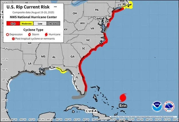
Swells generated by the storm could produce wave heights of 20 to 30 feet—and possibly up to 50 feet near its center. These swells are expected to impact much of Florida’s coastline, increasing likelihood of life-threatening rip currents to Florida's coast.
Along Northeast Florida beaches, Surf heights could reach 7 to 10 feet between August 19 and 21. Farther south, along east central Florida, waves are forecast to peak at 9 to 11 feet, with some reaching up to 14 feet on August 20, according to the National Weather Service in Melbourne.
U.S Rip Current Risk conditions from FL to NY
“This is going to make for very dangerous marine conditions across all of the western Atlantic and increase the risk for dangerous and life-threatening surf and rip current conditions across almost the entire US East Coast,” Brennan said.
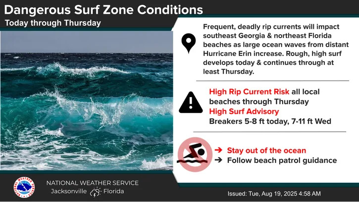
Jacksonville: 'Stay out of the ocean'
In Northeast Florida, ocean breakers of greater than seven feet are expected Tuesday through Thursday, according to the Weather Service, with the peak wave height around high tide on Wednesday. Minor coastal and tidal flooding is possible with "at least moderate beach erosion," said NWS meteorologist Angela Enyedi. Moderate beach erosion is possible during the early Wednesday evening high tide.
The National Weather Service is advising everyone, including surfers, to 'stay out of the ocean' as High Rip Current risk will impact all local beaches with a High Surf Advisory in effect until Thursday with breakers reaching 5 to 8 ft today and 7 to 11ft Wednesday.
How is Hurricane Erin impacting Jacksonville this week?
Here's a breakdown for the week:
Tuesday: Seas will build to 6-8 feet offshore after midnight and to Caution levels of 4-6 feet near shore this evening, building further to 5-7 feet during the predawn hours on Tuesday. Deadly surf conditions will begin on Tuesday all along the coast, with breaker heights building to 6-8 feet by the afternoon hours at Northeast Florida beaches
Wednesday: Seas will peak in the 8-11 foot range near shore on Wednesday and Wednesday night, while seas offshore peak in the 11-14 foot range on Wednesday. A high surf advisory will likely be issued for the Northeast Florida beaches from Tuesday through at least Thursday night, with breakers peaking in the 9-11 foot range on Wednesday.
Thursday: Expect seas ranging from 6 to 9 feet, Shashy said, and to remain elevated through the weekend.
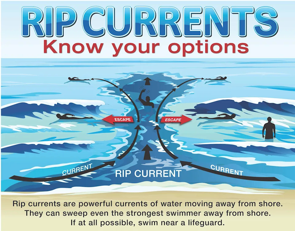
What is a rip current?
Rip currents are powerful channels of water flowing quickly away from shore, which occur most often at low spots or breaks in the sandbar and in the vicinity of structures such as jetties and piers.
Rip currents form when incoming waves create an underwater sandbar. The waves push more water between the sandbar and the shore until it collapses and the water rushes back to the sea through a narrow gap, where it starts to spread out. But they can be difficult to see when you're in the water as the ocean over them can still be smooth.
Entering the surf is strongly discouraged. If caught in a rip current, relax and float. Don`t swim against the current. If able, swim in a direction following the shoreline. If unable to escape, face the shore and call or wave for help.
Hurricane Erin projected path. See current location
Special note on the NHC cone: The forecast track shows the most likely path of the center of the storm. It does not illustrate the full width of the storm or its impacts, and the center of the storm is likely to travel outside the cone up to 33% of the time.
Location: 665 miles southwest of Bermuda; 720 miles south-southeast of Cape Hatteras, North Carolina; and 518 miles east of Stuart
Maximum sustained winds: 110 mph
Movement: northwest at 7 mph
Pressure: 958 mb
Next advisory: 11 a.m. ET
North Carolina braces for Hurricane Erin. Watches issued
Several watches associated with Erin have been issued for North Carolina:
Storm surge watch: Cape Lookout to Duck, North Carolina
Tropical storm watch: Beaufort Inlet to Duck, North Carolina including Pamlico Sound
The storm’s rapid intensification prompted increased emergency measures in North Carolina. The Outer Banks — a popular summer vacation spot — are under a state of emergency. Officials mandated evacuations for Hatteras Island, ordering visitors to leave by 10 a.m. Monday, Aug. 18, and residents by 8 a.m. Tuesday, Aug. 19, as forecasters warned of life-threatening rip currents, large swells, coastal flooding and road washouts.
The hurricane center warned storm surge could cause the water to rise 2 to 4 feet above dry ground along the Outer Banks as Erin moves north.
➤ NC declares state of emergency in Outer Banks. See Hurricane Erin tracker
Residents along the North Carolina coast were warned there is a risk of strong winds associated with the outer rainbands of Erin around the middle of the week, as well as a threat for significant coastal flooding and beach erosion, according to the National Weather Service's Weather Prediction Center.
Spaghetti models for Hurricane Erin. See projected path
Special note about spaghetti models: Illustrations include an array of forecast tools and models, and not all are created equal. The hurricane center uses only the top four or five highest performing models to help make its forecasts.
How strong is Hurricane Erin and where could it go?
At 8 a.m., the center of Hurricane Erin was located near latitude 25.2 North, longitude 72.2 West.
Erin is moving toward the northwest near 7 mph. A turn toward the north-northwest with an increase in forward speed is expected today, followed by a northward motion on Wednesday and then a northeastward motion on Thursday.
On the forecast track, the center of Erin will pass to the east of the Bahamas today and tonight, and then move over the western Atlantic between the U.S. east coast and Bermuda on Wednesday and Thursday.
Maximum sustained winds are near 110 mph, with higher gusts. Fluctuations in strength are possible over the next few days.
Erin is a large hurricane. Hurricane-force winds extend outward up to 80 miles from the center and tropical-storm-force winds extend outward up to 205 miles.
Where have watches and warnings been issued for Hurricane Erin?
A tropical storm warning is in effect for:
Turks and Caicos Islands
Southeast Bahamas
A tropical storm watch is in effect for:
Central Bahamas
Beaufort Inlet to Duck, North Carolina including Pamlico Sound
A storm surge watch is in effect for:
Cape Lookout to Duck, North Carolina
Key messages from the National Hurricane Center: What you need to know about Hurricane Erin
Erin is expected to produce life-threatening surf and rip currents along the beaches of the Bahamas, much of the east coast of the U.S., Bermuda, and Atlantic Canada during the next several days. Beachgoers in those areas should follow advice from lifeguards, local authorities, and beach warning flags.
Tropical storm conditions and coastal flooding are possible in the North Carolina Outer Banks beginning late Wednesday or Wednesday night where Tropical Storm and Storm Surge Watches are in effect. Interests in along the U.S. Mid-Atlantic and southern New England coasts and on Bermuda should also monitor the progress of Erin as strong winds are possible Thursday and Friday.
Heavy rainfall from the outer bands of Erin will continue today for the Turks and Caicos and through tonight for the Bahamas. Flash and urban flooding are possible.
Tropical storm conditions are expected in the Turks and Caicos Islands and in the southeast Bahamas for a few more hours. Tropical storm conditions are possible in portions of the central Bahamas today.
Current forecast: How strong could Hurricane Erin get?
At 5 a.m.: 115 mph
12 hours: 110 mph
24 hours: 110 mph
36 hours: 115 mph
48 hours: 115 mph
60 hours: 110 mph
72 hours: 105 mph
96 hours: 85 mph
120 hours: 75 mph
Hurricane categories: Saffir-Simpson Hurricane Wind Scale
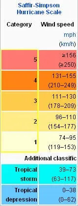
Category 1 hurricane: 74-95 mph
Category 2 hurricane: 96-110 mph
Category 3 hurricane: 111-129 mph
Category 4 hurricane: 130-156 mph
Category 5 hurricane: 157 mph or higher
Interactive map: What tropical storms, hurricanes have impacted your area in the past?
Stay informed. Get weather alerts via text
This article originally appeared on Florida Times-Union: Hurricane Erin is causing deadly rip currents. Here's what to know


Comments