Hurricane Erin is growing in size and impacts from coastal flooding and eventually tropical storm winds will increase in parts of North Carolina and the Virginia Tidewater. Erin is also a major high surf and rip current danger for virtually the entire East Coast the next few days.
(MORE: Erin Maps Tracker - Spaghetti Models, Forecasts, More)
Where Erin Is Now
Erin's center is currently less than 500 miles south-southeast of Hatteras, North Carolina, or in between North Carolina and Bermuda. Erin continues to move north-northwestward.
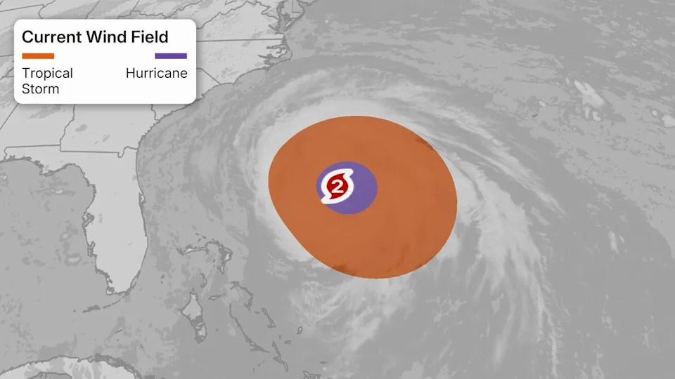
While its maximum sustained winds are not as extreme as they were last weekend, it remains a powerful hurricane. Just as importantly, though, the size of Erin's tropical-storm- and hurricane-force winds has increased dramatically over the past few days, as expected.
(MORE: Why A Hurricane's Size Matters)
Watches And Warnings
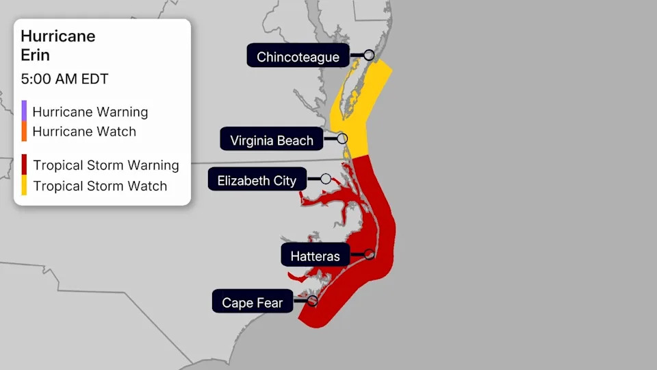
Tropical storm warnings have been issued in eastern North Carolina from Beaufort Inlet to the Virginia border, including Pamlico and Albemarle Sounds. A storm surge warning is also in effect in the Outer Banks from Cape Lookout to Duck, North Carolina. These warnings mean tropical storm conditions and storm surge flooding are expected within the next 48 hours.
A tropical storm watch has been issued northward in southeast Virginia to Chincoteague, Virginia, and also for Bermuda. This means that tropical storm conditions are possible within 48 hours.
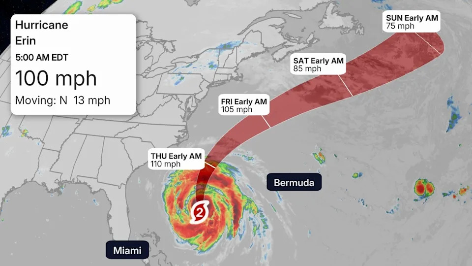
Path, Intensity Forecast
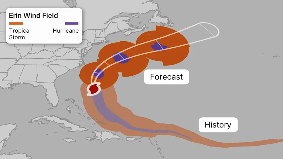
As the forecast path graphic below shows, Erin's center will curl northeastward between North Carolina and Bermuda and south of Atlantic Canada.
Erin is expected to remain a strong hurricane with some fluctuations in intensity possible. While further significant intensification isn't likely, Erin's large and growing size means tropical storm force winds are increasingly likely in outer rainbands for the Outer Banks of North Carolina and possibly in Bermuda. We even can't rule out a few stronger gusts making their way farther up the East Coast into the mid-Atlantic or even southeast New England.
That said, we do not expect Erin's strongest hurricane-force winds to come anywhere close to the East Coast or Bermuda.
Potential U.S. Impacts
Storm Surge
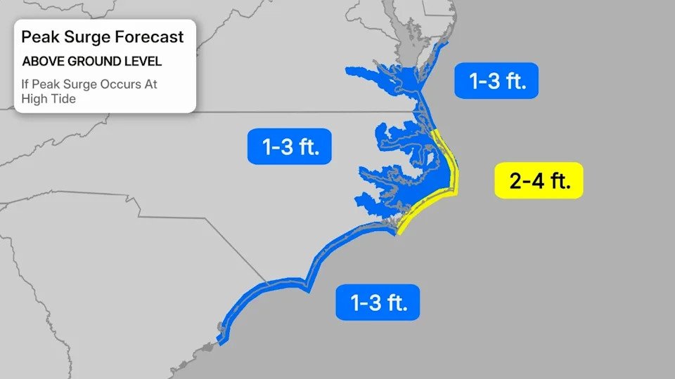
Erin's large size means it will push water from the ocean toward coastal areas, leading to flooding of normally dry areas at high tide from the Virginia Tidewater to the coastal Carolinas.
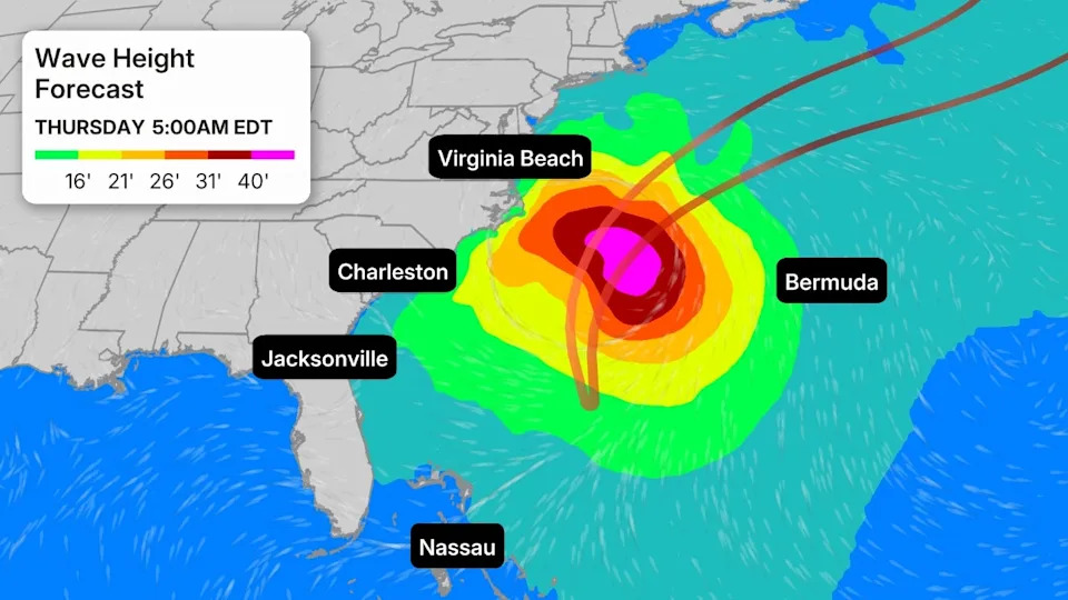
The high tide where coastal flooding may be most expansive and significant appears to be early Thursday evening from the southern Delmarva Peninsula and southern Chesapeake Bay into eastern North Carolina. That's when inundation may reach the values shown in the map below, flooding roads and possibly some properties, particularly in the Outer Banks.
This will strongly affect Highway 12 in the Outer Banks with overwash and washouts through at least Thursday.
Minor to moderate coastal flooding is also expected with Wednesday evening's high tide in coastal South Carolina and southern North Carolina, including Charleston. Moderate coastal flooding at high tide is also expected Thursday and Friday farther north into coastal Delaware and New Jersey.
Some coastal flooding may persist into Friday before water levels gradually recede this weekend.
High Surf, Rip Currents
Erin will generate life-threatening, dangerous high surf and rip currents all along the East Coast, from Florida to southern New England the next several days.
This will last through the weekend, even as Erin moves into the open waters of the North Atlantic.
Monday, 60 to 80 rip current rescues were required at Wrightsville Beach, North Carolina. Another 15 rescues were conducted Tuesday.
Of all hurricane hazards, 16% of fatalities come from rip currents and rough seas. Heed all advice from lifeguards, local officials and any warning flags flying at the beach.
If in doubt, don't wander into the surf on Atlantic beaches this week.
Winds
To emphasize, we do not expect the core of Erin's strongest hurricane winds to affect any part of the U.S. East Coast, nor Bermuda.
However, given Erin's size, tropical storm force winds are increasingly likely in eastern North Carolina, even though the center will remain well offshore. These winds could arrive as soon as late Wednesday and continue into Thursday. These winds may down some tree limbs and could knock out power in a few areas.
There's also a small chance of at least a few stronger gusts farther up the Eastern Seaboard from the Delmarva Peninsula to southeast New England Thursday into Friday.
In Bermuda, tropical storm force winds are possible Thursday and Friday.
Rain
According to the National Hurricane Center, parts of eastern North Carolina could pick up 1 to 2 inches of rain in outer rainbands from Erin through Thursday.
This rainfall could add to the flooding from surge at high tide in this area.
Erin's History
Meteorologists first began watching the area of instability that eventually formed Hurricane Erin several days before the storm was named Monday of this past week.
The system remained a tropical storm as it traveled westward across the Atlantic, weakening slightly mid-week as it battled cooler waters.
Thanks to warmer waters in the western Atlantic, Erin began a period of explosive rapid intensification starting on Friday, going from a tropical storm to Category 5 in just under 30 hours, and from a Category 3 to a Category 5 in just under 6 hours.
Erin has also joined a rare group of only five hurricanes that have wind speeds of at least 145 mph by August 16 since 1970, according to Dr. Phil Klotzbach. Erin is the first Category 5 hurricane since Milton and Beryl in 2024.
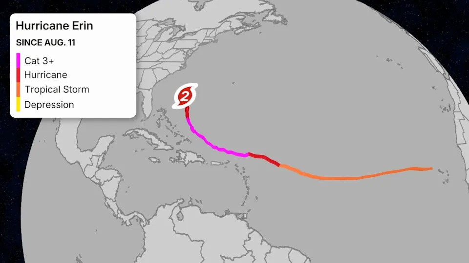
Erin began to undergo an eyewall replacement cycle on Saturday, setting off a period of fluctuation in intensity and bringing the storm back to Category 4 intensity by Saturday evening.
While Erin has been skirting around islands in the Caribbean, a wind gust of 57 mph was recorded on the island Tortola in the British Virgin Islands Saturday evening, but sustained tropical storm force winds have remained to the north of the islands so far.
Erin dumped up to 6 inches of rain in Puerto Rico and up to 7 inches of rain in the U.S. Virgin Islands, according to the National Weather Service.
Winds gusted to 53 mph in the Turks and Caicos, as Erin passed near the group of islands southeast of the Bahamas earlier this week, according to the National Hurricane Center.
Jennifer Gray is a weather and climate writer for weather.com. She has been covering some of the world's biggest weather and climate stories for the last two decades. Jonathan Erdman is a senior meteorologist at weather.com and has been covering national and international weather since 1996. Extreme and bizarre weather are his favorite topics. Reach out to him on Bluesky, X (formerly Twitter) and Facebook.


Comments