(The Center Square) – Outer bands of Hurricane Erin are at the shores of the Carolinas, the National Hurricane Center said in its 5 p.m. report on Wednesday.
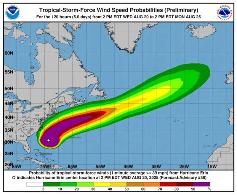
Category 2 Erin has maximum sustained winds of 110 mph and was 295 miles south-southeast of Cape Hatteras. Hurricane force winds of 74 mph or greater were extending 105 miles from its core, and tropical storm force winds of 39 mph or greater were outward to 265 miles.
Erin was moving at 14 mph and due north preceding a forecast turn more northeast.
From the Carolinas to New England, coastal communities were in preparation. The storm’s timing comes while the 63rd annual Coastal Edge East Coast Surfing Championships are at the Virginia Beach Oceanfront through Sunday.
Tropical storm conditions were expected overnight Wednesday into Thursday at the Outer Banks in North Carolina and up into the Tidewater of Virginia. Storm surge between Cape Lookout and Duck was forecast 2 to 4 feet; elsewhere from Charleston, S.C., to Chincoteague, Va., the rise was projected at 1 to 3 feet.
The next high tides on the Outer Banks are 6:18 p.m. Wednesday, and Thursday at 6:45 a.m. and 7:10 p.m.
Erin has already sent Atlantic Ocean water over dunes and N.C. 12, the famed 148-mile roadway linking peninsulas and islands of the Outer Banks.
Mandatory evacuations have been issued for Ocracoke Island in Hyde County and Hatteras Island in Dare County. Each county has declared an emergency.
Storm surge warnings were in effect from Cape Lookout to Duck; and a tropical storm warning was in effect from Beaufort Inlet to the Chincoteague, Va., inclusive of the Pamlico and Albemarle sounds.
The Wednesday evening high tide for coastal South Carolina, including Charleston, and southern North Carolina is being closely watched for flooding. Early Thursday evening is the expected time of coastal flooding from the southern Delmarva Peninsula and southern Chesapeake Bay down to eastern North Carolina.
The storm’s projected path through the weekend skirts parallel to moving more away from the Atlantic Seaboard. Thursday’s pass is by the Carolinas and Virginia, and Friday the storm will be moving by Maine.
As often happens with hurricanes, water began to run over N.C. 12 on Tuesday. The highway begins at U.S. 70 at the community of Sea Level and runs to a point just north of Corolla and south of the Currituck Banks North Carolina National Estuarine Research Reserve. Two ferries, Hatteras Island to Ocracoke Island and Cedar Island to Ocracoke Island, are part of the route.
The storm's landfall miss of the state is particularly welcome in light of Hurricane Helene. Recovery from that storm is in its 47th week. Helene killed 107 in the state, 236 across seven states in the South, and caused an estimated $60 billion in damage to North Carolina.


Comments