Simply put, today is the day that Hurricane Erin will do its worst along the U.S. East Coast. We're already see the large waves and coastal flooding in North Carolina's Outer Banks, but this large storm's trek northeast is also pushing ocean swells high onto beaches along New York's Fire Island and the Jersey Shore.
Our meteorologists have a full rundown of where Erin is now, where it's headed today and when you can expect the peak of today's impacts.
Our team will also keep you updated throughout the day on where the flooding is happening and the closures that result.
(09:39 a.m. EDT) How Close Was Erin?
From senior meteorologist Jonathan Erdman:
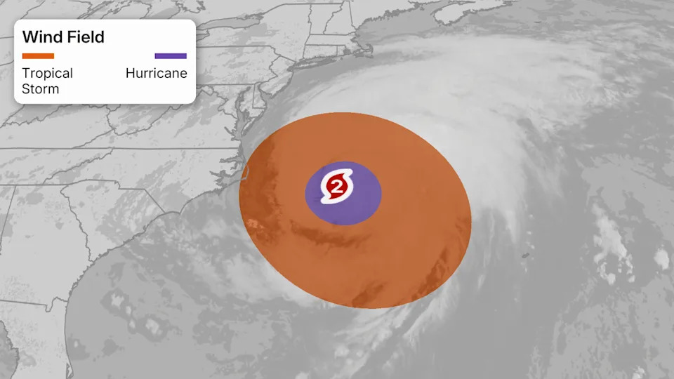
It turned out, Erin’s center came as close as 200 miles east-southeast of Hatteras, North Carolina, as of 2 a.m. ET today.
But given Erin’s tropical storm force winds were up to 480 miles wide, it is bringing tropical storm conditions to coastal North Carolina and the Virginia Tidewater today, not to mention coastal flooding, high surf and rip currents along the East Coast.
A hurricane — especially one this large — doesn’t have to make landfall to be impactful.
(09:20 a.m. EDT) Massive Swells At Popular Florida Pier
A Florida meteorologist shared some impressive sunrise video of huge ocean swells crashing onto Juno Beach. The waves popped out a few boards of the Juno Pier, which remains open right now.
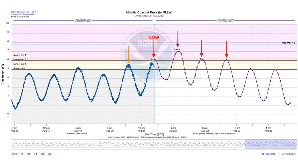
(09:00 a.m. EDT) Another High Tide
From senior meteorologist Jonathan Erdman:
We’re at another high tide along the East Coast and, as you can see in the graphic from the National Weather Service below, there are three more high tides after this morning where coastal flooding is expected in the northern Outer Banks of North Carolina.
This evening’s high tide is the one where flooding may be greatest from North Carolina to the Jersey shore, as northeast winds from soon departing Hurricane Erin keep pushing water to the coast.
(08:44 a.m. EDT) Will NC-12 Hold?
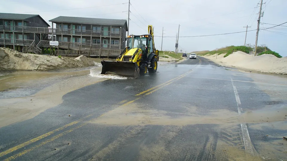
From managing editor Sean Breslin:
That’s the million-dollar question along North Carolina’s Outer Banks. The highway known as NC-12 is a lifeline for locals, vacationers and emergency responders alike. It spans about 150 miles, connecting the islands of the Outer Banks, but stretches of it have been destroyed by hurricanes of previous years.
Last night, about a 48-mile stretch of the highway was closed due to storm surge between Oregon Inlet and Hatteras Village.
(08:40 a.m. EDT) Welcome To Day 11 Of Erin
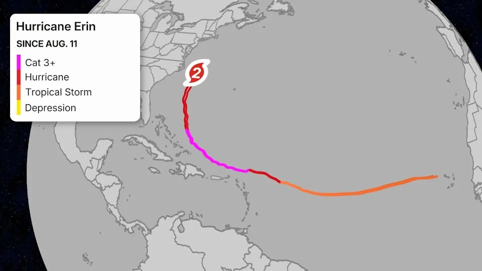
From senior meteorologist Jonathan Erdman:
This "Cabo Verde" storm already made quite a voyage. It's 2,941 miles away from where it first became a tropical storm 10 days ago near Cabo Verde.
(08:16 a.m. EDT) Sun Rises On East Coast
From senior writer Chris DeWeese:
Early risers along the East Coast are posting photos to social media of a pretty spectacular sunrise, courtesy of Hurricane Erin’s moisture. This photo from Charleston, South Carolina, was just posted by meteorologist Joey Sovine.
(07:47 a.m. EDT) Imagine Being On This Ferry
From managing editor Sean Breslin:
Keeping in mind that this is all the way up near the Rhode Island coast, check out how this boat was jostled by large waves yesterday evening:
(07:34 a.m. EDT) Buoy Shows 44.9 Foot Wave Height From Hurricane Erin
From senior writer Chris DeWeese:
Hurricane Erin is a huge storm capable of producing some giant waves. Many of these waves will remain unknown and unrecorded, but there are plenty of buoys out in the Atlantic capable of picking up data to give us some sense of what’s going on out there.
Keep an eye on buoy 41001, located 150 nautical miles east of Cape Hatteras, which recently reported significant wave heights of 44.9 feet. As senior digital meteorologist Jonathan Erdman explains, since "max wave heights" are usually 2x the sig. wave heights....there could be up to 90-foot waves well offshore!”


Comments