Fall is coming to the Florida Panhandle, and a cold front will bring the first signs of it next week when highs escape the 90s and lows dip into the upper 60s.
Before the Pensacola area can see some cooler and drier air, it will go through a weekend of scattered afternoon showers and thunderstorms in a typical summer pattern.
Meanwhile, in the Atlantic, tropical activity has exploded after Hurricane Erin formed and ran up the eastern coast. The National Hurricane Center is tracking three tropical waves with varying chances of developing.
One of those waves, dubbed Invest 99L, is worth keeping an eye on in the Florida Panhandle.
Invest 99L’s development will be touch-and-go over the next week. It has a small window of opportunity to develop into a short-lived tropical depression over the next day or so before it moves into less conducive conditions.
The NHC’s latest advisory indicates that it could track south of the Caribbean Islands, placing it into an area where further development is more likely.
Here’s a look at the latest forecast for the Pensacola area.
Where is Hurricane Erin?
Erin remains a very large Category 1 hurricane that is moving east-northeastward near 28 mph. It’s located near latitude 38.8 North, longitude 63.1 West, which is hundreds of miles directly east of New York and south of Nova Scotia.
NHC forecasters expect Erin to fully transition into an extratropical storm by Friday night, and it’s expected to become even larger and more powerful later Saturday into Sunday. Forecasters say that Erin will start to weaken next week as it occludes and loses its upper support south of Iceland.
NHC tracks three tropical waves in the Atlantic
The National Hurricane Center is tracking a trio of tropical waves in the Atlantic basin, dubbing two as invests. Of the three, Invest 99L is the one to keep an eye on in the Florida Panhandle.
Leeward Islands wave (Invest 90L)
Showers and thunderstorms are showing some signs of organization in association with a tropical wave located about a hundred miles east-northeast of the northern Leeward Islands. Environmental conditions appear conducive for further development of this system, and a tropical depression or tropical storm is very likely to form this weekend while it moves northwestward and then northward, between the northern Leeward Islands and Bermuda.
Formation chance through 48 hours: 80%
Formation chance through 7 days: 90%
Central tropical Atlantic wave (Invest 99L)
Showers and thunderstorms associated with a tropical wave located about midway between Africa and the Windward Islands have become less organized overnight. While there is still some chance that a short-lived tropical depression could form during the next day or so, the system is expected to move through a less conducive environment into Saturday. The wave could reach a slightly more favorable environment again late this weekend into early next week as it moves westward at 10 to 15 mph over the central tropical Atlantic and approaches the Lesser Antilles.
Formation chance through 48 hours: 40%
Formation chance through 7 days: 50%
Central subtropical Atlantic wave
A small area of low pressure located well southwest of the Azores has weakened overnight, and no development is expected while it drifts northward.
Formation chance through 48 hours: 0%
Formation chance through 7 days: 0%
What is a tropical invest?
Meteorologists use the term “invest” to describe a tropical weather system that they are interested in collecting specialized data sets or running model guidance for, according to the NHC It isn’t used as an indicator of the likelihood a system will develop into a tropical cyclone.
Pensacola area 7-day weather forecast
Here’s a look at the National Weather Service’s seven-day weather forecast for the Pensacola area.
Friday, Aug. 22
High: 89
Low: 75
Chance of rain: 70%
Notes: Showers and thunderstorms likely, mainly after 1 p.m. A second round is expected Friday night. New rainfall amounts between a half and three-quarters of an inch are possible during the day; between a tenth and a quarter of an inch are expected Friday night.
Saturday, Aug. 23
High: 88
Low: 75
Chance of rain: 60%
Notes: Showers are likely and possibly a thunderstorm before 1 p.m., then a chance of showers and thunderstorms after 1 p.m. Saturday night brings a 30% chance of showers.
Sunday, Aug. 24
High: 91
Low: 75
Chance of rain: 30%
Monday, Aug. 25
High: 93
Low: 72
Chance of rain: None
Tuesday, Aug. 26
High: 91
Low: 72
Chance of rain: None
Wednesday, Aug. 27
High: 89
Low: 69
Chance of rain: None
Thursday, Aug. 28
High: 89
Chance of rain: 20%
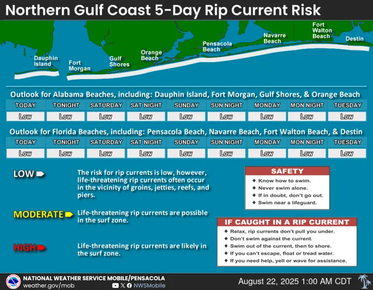
Five-day rip current risk for the Florida Panhandle
This article originally appeared on Pensacola News Journal: Florida Panhandle will see slightly cooler temperatures next week


Comments