In a rush? Get an abbreviated, text view of what's happening in the tropics.
We're in the middle of the busiest time of the Atlantic hurricane season but the National Hurricane Center's tropical outlook map is empty, except for Tropical Storm Fernand in the middle of the Atlantic, according to the latest advisory.
What's happening and how long will the lull last?
➤ Weather alerts via text: Sign up to get updates about current storms and weather events by location
Don't let down your guard, forecasters warned.
"Sometimes you can get these lulls in the middle of the hurricane season, and it looks like we are going to be having one, at least across the main (storm) development region," said Alex DaSilva, lead hurricane expert for AccuWeather.
The next named storms of the season will be Gabrielle and Humberto.
Here's the latest advisory from the National Hurricane Center as of 8 a.m. Aug. 26:
See projected path for Tropical Storm Fernand
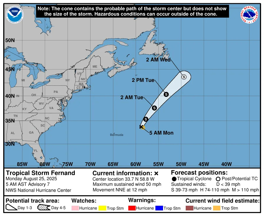
Special note on the NHC cone: The forecast track shows the most likely path of the center of the storm. It does not illustrate the full width of the storm or its impacts, and the center of the storm is likely to travel outside the cone up to 33% of the time.
➤ Track Tropical Storm Fernand
Fernand is moving toward the northeast near 14 mph.
Maximum sustained winds have decreased to near 45 mph (75 km/h) with higher gusts. Continued weakening is likely, and Fernand is likely to become a post-tropical cyclone later tonight or early Wednesday before dissipating on Thursday.
There are no hazards to land associated with Fernand.
What tropical waves, disturbances are in Atlantic basin now?
The National Hurricane Center is tracking Tropical Storm Fernand and four tropical waves in the Atlantic basin, which consists of the northern Atlantic, Caribbean and Gulf.
Tropical wave 1: A far eastern Atlantic tropical wave is analyzed near 25W from 18N and the western Cabo Verde Islands southward, moving west at around 17 mph.
Tropical wave 2: A central Atlantic tropical wave is analyzed along 52.5W, from 20N southward, moving west at around 17 mph.
Tropical wave 3: A central Caribbean tropical wave is analyzed along 72W, from near the border of Colombia and Venezuela, moving west at around 23 mph.
Tropical wave 4: The northern tip of a tropical wave is in the central Bay of Campeche near 93W south of 21N and into the eastern Pacific Ocean, moving west at around 11 mph.
Is there a hurricane heading toward Florida?
No. Tropical Storm Fernand poses no threat to land and there's nothing else out there at this time.
"Unfavorable upper-level wind conditions are expected to kick up this week over the Atlantic’s Main Development Region, and the end of August and first week of September should be relatively quiet in the tropics," said Dr. Ryan Truchelut on Aug. 13. Truchelut is the chief meteorologist at WeatherTiger and works with the USA TODAY Network.
➤ Hurricane forecast: Quiet spell likley until mid-September
Mid-August through mid-October is the busiest portion of hurricane season, and officials regularly urge residents to always be prepared for storms.
Could Florida face any tropical risks last week of August?
There is a low risk of tropical development late this week off the Southeast coast of the Atlantic and in the western Gulf, according to AccuWeather.
AccuWeather meteorologists warn that additional areas are also being closely monitored for development. There is a low risk of tropical development late this week off the Southeast coast of the Atlantic and in the western Gulf.
“A front is forecast to stall near the Atlantic and Gulf coasts,” said AccuWeather Lead Hurricane Expert Alex DaSilva.
“This stalled boundary could produce a storm that could develop tropical characteristics around the holiday weekend.”
Hurricane Erin left behind a corridor of cooler water over the Atlantic, but sea-surface temperatures are expected to rebound during the next week or two, according to AccuWeather.
“By late this week, the Atlantic should again be warm enough to support tropical development, while the Gulf remains sufficiently warm for formation west of Florida,” DaSilva said.
Colorado State University predicting 'quieter period' in Atlantic basin for Aug. 20-Sept. 2
"Following Hurricane Erin becoming post-tropical ... we anticipate a quieter period for Atlantic hurricane activity," Colorado State University said in its two-week forecast for Aug. 20-Sept. 2.
Historically, "the primary threat formation area for major hurricanes in late August is in the eastern and central tropical Atlantic," CSU said.
"We are approaching the climatological peak of the season, and there is certainly potential for other TCs — tropical cyclones — to form, especially given that the large-scale environment doesn't look especially harsh."
What should you do now to prepare for hurricane season?
Officials regularly encourage Florida residents to prepare for storms before a hurricane is approaching, while shelves are fully stocked and you aren't battling crowds all rushing to the store at the same time.
➤ Don't have a hurricane supply kit? From the basics to the extras, here's what you need
"It only takes one storm to make it an impactful year for your community," the National Hurricane Center Miami posted on X. "Hurricane season is a marathon, not a sprint."
On Aug. 1, specific hurricane supplies became permanently tax-free in Florida, ranging from batteries to generators.
➤ See list of emergency supplies you can now buy tax free
Florida weather radar for Aug. 26, 2025
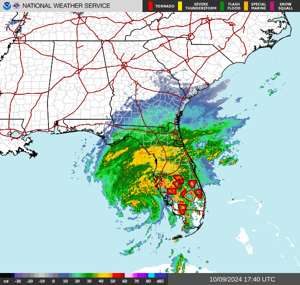
Weather watches and warnings issued in Florida
When is the Atlantic hurricane season?
The Atlantic hurricane season runs from June 1 through Nov. 30.
Ninety-seven percent of tropical cyclone activity occurs during this time period, NOAA said.
The Atlantic basin includes the northern Atlantic Ocean, Caribbean Sea and Gulf of America, as the Gulf of Mexico is now known in the U.S. per an order from President Trump. NOAA and the National Hurricane Center are now using Gulf of America on its maps and in its advisories.
When is the peak of hurricane season?
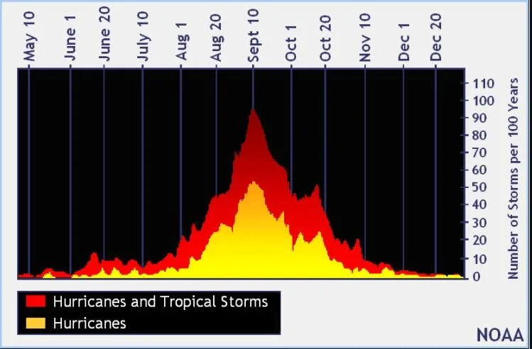
The peak of the season is Sept. 10, with the most activity happening between mid-August and mid-October, according to the Hurricane Center.
Hurricane names for 2025 season
Here are the names for the 2025 Atlantic hurricane season, along with how to pronounce them.
Andrea(June 20)Barry(June 29)Chantal(July 5)Dexter: (Aug. 3)Erin: (Aug. 11; hurricane Aug. 15; major hurricane Aug. 16)Fernand: (Aug. 23)
Gabrielle: ga-bree-ELL
Humberto: oom-BAIR-toh
Imelda: ee-MEHL-dah
Jerry: JEHR-ee
Karen: KAIR-ren
Lorenzo: loh-REN-zoh
Melissa: meh-LIH-suh
Nestor: NES-tor
Olga: OAL-guh
Pablo: PAHB-lo
Rebekah: reh-BEH-kuh
Sebastien: se-BAS-tee-en
Tanya: TAHN-yuh
Van: van
Wendy: WEN-dee
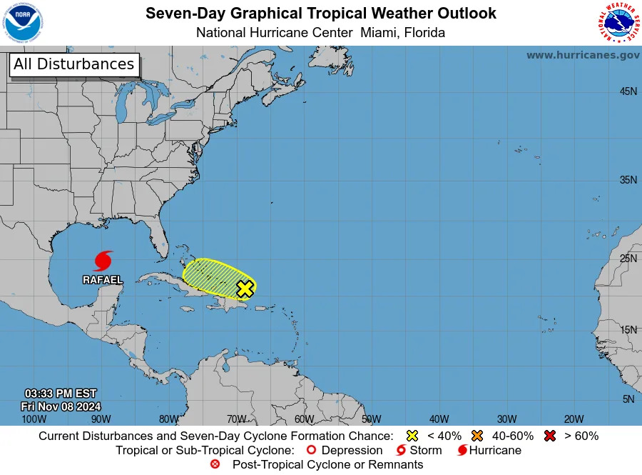
National Hurricane Center map: See what forecasters are watching now
Systems currently being monitored by the National Hurricane Center include:
Interactive map: Hurricanes, tropical storms that have passed near your city
Stay informed. Get weather alerts via text
What's next?
We will update our tropical weather coverage daily.
Download your local site's app to ensure you're always connected to the news. And look for our special subscription offers here.
This article originally appeared on Fort Myers News-Press: NOAA tracking 4 tropical waves, Fernand. What to do in Florida


Comments