Tsunami waves reached Hawaii and the West Coast after one of the strongest earthquakes in recorded history, a magnitude 8.8 temblor, struck off Russia's Kamchatka Peninsula on July 29 before most of the warnings were downgraded hours later.
The waves began arriving in Hawaii after 7 p.m. local time, but initial observations were heartening to officials bracing for major damage in the state. By 10:45, authorities announced that the Tsunami Warning System had downgraded risk to the state from a tsunami warning to an advisory. There were no major reports of damage.
"Evacuations canceled for Oahu. Residents may return home," state emergency management officials posted on social media July 30. "Remain cautious in or near the water. Widespread flooding is NOT expected. Stay away from beaches, shorelines, and out of the ocean."
Tsunami waves began to arrive at Crescent City, California, and Humboldt Bay overnight, the weather service in Eureka posted on X. Tsunamis can cause a long series of waves, extensively flood coastal areas and present dangers that continue for many hours.
"Tsunami activity is continuing to build this morning as we approach the 4 AM minor high tide," the weather service posted July 30 on X. The post said maximum confirmed heights for the coast included 3.6 feet at Crescent City and urged residents to avoid beaches and harbors "as tsunami activity will persist."
Crescent City is located along a stretch of the West Coast under a tsunami warning, an upgraded risk level from the rest of the West Coast. The area is considered more vulnerable to tsunamis than any other part of the West Coast based on previous events, according to the National Oceanic and Atmospheric Administration. The waves get amplified in the area and are higher in the city’s harbor than at other locations along the coast.
Meanwhile, along the Washington Coast, tsunami waves began arriving just after midnight local time, according to the Seattle weather service office, but wave height measurements weren't yet available.
Alaska could feel impact for days, forecasters warn
Initial tsunami warnings have been cancelled or downgraded in much of Alaska, but an advisory still exists along the state's Aleutian Islands and the Alaska Peninsula along an over 1,000-mile stretch from Attu Island to Chignik Bay, according to the National Weather Service in Anchorage as of 2:45 a.m. local time.
Currents at beaches and harbors, marinas, bays and inlets can be especially dangerous in the wake of tsunami waves and the danger can last for days, forecasters said.
Tsunami waves have been recorded at gauges along the Aleutian Islands, with the highest wave of 2.7 feet near Adak Island at about 10:21 p.m. local time on July 29.
“Impacts from Tsunamis may continue for many hours to days after arrival of the first wave,” forecasters said.
In Russia, some damage and injuries
The earthquake was recorded at 7:24 p.m. ET, about 78 miles east-southeast of Petropavlovsk-Kamchatsky, Russia, the U.S. Geological Survey (USGS) said. The agency stated that the quake was shallow, occurring at a depth of approximately 12 miles.
A wall collapsed in a kindergarten in Petropavlovsk-Kamchatsky, but there were no casualties, the Russian news agency Tass reported. Elsewhere, several people sought medical assistance, Tass said. And a tsunami wave made landfall on the coast near Severo-Kurilsk, the government of the Sakhalin Region told Tass.
What is the Pacific Tsunami Center?
The United States is served by two tsunami centers operated by the National Oceanic and Atmospheric Administration. The Pacific Tsunami Warning Center serves the Hawaiian Islands, the Pacific and Caribbean territories and the British Virgin Islands. It also covers the international forecast for nations in the Pacific and Caribbean Basins. It’s located on Hawaii’s Ford Island, on the south side of Oahu near Pearl Harbor.
The other, the National Tsunami Warning Center, serves the mainland United States, Alaska and Canada. The warning centers are staffed 24/7 to monitor for tsunamis or earthquakes that could cause them, issue tsunami messages and work to improve warnings.
The Pacific Tsunami Warning Center was first established in the wake of official tsunami warnings that began in 1949, in response to a 1946 tsunami that devastated Hilo, Hawaii, known as the April Fools Day Tsunami.
Trump warns of tsunami on social media
Shortly before 11:30 p.m. ET, a tsunami advisory was upgraded to a warning for the coastal areas of California, from Cape Mendocino to the Oregon-California border, the weather service said. A tsunami warning means significant inundation is possible.
Earlier in the night, President Donald Trump took to social media to warn of the tsunami.
"Due to a massive earthquake that occurred in the Pacific Ocean, a Tsunami Warning is in effect for those living in Hawaii," he posted on X. "... STAY STRONG AND STAY SAFE!"
Most areas along the U.S. Pacific Coast can expect a tsunami of less than 1 foot, the National Weather Service said just after 10:30 p.m. E.T. But even a tsunami of that size can generate deadly currents, the weather service warned.
What is a tsunami warning? What to know after huge earthquake.
Tsunami waves recorded in Hawaii
After authorities urged residents and tourists to move to higher ground and evacuate from coastal zones, initial data showed waves arriving on the evening of July 29 were less than the potential projected maximum of 9.8 feet.
Tsunami waves in Hawaii reached amplitudes of up to 5.7 feet in Kahului, Maui, a measurement that compares the wave to height above normal sea level, the weather service said. In Hilo, the wave amplitude reached 4.9 feet.
"Look, everything has been OK so far. We haven't seen a big wave," Green said at around 8:30 p.m. But he said officials were concerned about an earlier pullback of water, which can signal a tsunami risk.
Context: Hawaii has a long history with tsunamis, thanks to the 'ring of fire'
Hawaii has a long history with tsunamis
The state of Hawaii is one of the more tsunami susceptible spots in the world, thanks to its remote location in the Pacific Ocean, surrounded by the infamous seismic activity known as the "ring of fire."
Tsunami waves can arrive in the islands from any location around the ocean, including Russia, South America and Alaska and the Aleutian Islands, according to the National Oceanic and Atmospheric Administration. On average, Hawaii experiences destructive tsunamis about once every 11 years.
The earliest historical accounts emerge from oral histories of the islands, including a 16th century chant about a wave that struck the coast of Molokai'i.
Read more: Hawaii has a long history with tsunamis, thanks to the 'ring of fire'
When was the tsunami predicted to hit Hawaii?
A tsunami warning was issued for Hawaii, according to the state's Department of Emergency Management. The agency estimated that the first tsunami wave will arrive at around 7:17 p.m., Hawaii Standard Time.
"A tsunami has been generated that could cause damage along coastlines of all islands in the state of Hawaii," the agency said in a bulletin. "Urgent action should be taken to protect lives and property."
The Honolulu Department of Emergency Management called for the evacuation of some coastal areas in Hawaii. "Take Action! Destructive tsunami waves expected," the Honolulu Department of Emergency Management said on X.
In a video update at 5:50 p.m. local time, Green said authorities were prepared and noted that county officials were “fully involved” in emergency management. The governor warned residents and visitors to not be outside on all shorelines when the wave strikes, adding that warning sirens will be used within the next hour.
“(The earthquake has) caused a wave we believe that will be significant,” Green said. “People need to evacuate — that’s very clear. They have to be out of the evacuation zone or up four stories.”
'It’s always scary to get an alert like that': Hawaii residents rush to higher ground
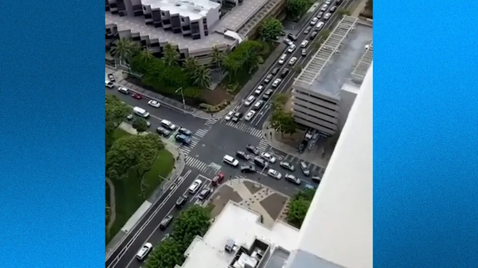
Shortly after the initial tsunami warning sirens went off at around 3 p.m. local time in Hawaii, the streets of Honolulu, including the tourist hub Waikiki, were congested as people quickly tried to move to higher ground and away from coastal evacuation zones. Some reported long lines at gas stations, as sirens continued to go off on the hour to the estimated first wave.
Oahu local Megan Lee said she hit more traffic than usual on her commute home from work. “It’s nice to see everyone taking it seriously,” Lee told USA TODAY. “It’s always scary to get an alert like that.”
Some felt desensitized to the warning following the 2018 false missile alert, when residents woke up to an emergency alert notification that a ballistic missle was headed their way. Residents across the islands scrambled to find shelter before learning it was sent as an error.
Lee, who was living on Oahu during the false missile alert, said she feels desensitized to these types of warnings. “It makes me not take the sirens as seriously, unfortunately,” she said. “We get a lot of alarms in Hawaii, and you see people going surfing because there’s a tsunami warning.”
Those living more inland said they’re not as concerned about the warning, like Honolulu resident Julie Shimer. “I think it’s great (the state) is being more cautious,” Shimer told USA TODAY. “It’s always better being more prepared just in case.”
In a statement sent on the afternoon of July 29, Honolulu Mayor Rick Blangiardi said, “Residents and visitors are urged to monitor local media for updates and stay away from the coastline. For those flying in or out of Hawaii today please check with your airline for the status of your flight.”
— Kathleen Wong
San Diego officials monitoring tsunami situation
In San Diego County, officials were monitoring the situation on the evening of July 29. San Diego County spokesperson Chuck Westerheide said the county would issue an alert if necessary, but stressed that so far, a tsunami advisory was all that was in place.
“As of 8:08 p.m. (local time) we are in an advisory area, meaning strong currents and a tsunami are possible and waves and currents can kill or injure people who are in the water,” Westerheide said. “But that’s key — people who are in the water.”
“Currents at beaches in harbors, marinas, bays and inlets may be especially dangerous,” he added.
Ilya Zaides, who lives on the beach in La Jolla, said he was monitoring X while also waiting to see if an official alert would be issued.
“We’re going to wait and see if there’s an alert, and hopefully there will be enough time to leave if we need to,” Zaides said.
— Will Carless
Tsunami activity possible in Alaska
The tsunami warning for Alaska includes coastal areas from Attu to Samalga Pass. The tsunami advisory has been expanded to areas from Samalga Pass to Chignik Bay. Expected tsunami start times in Alaska include the following: 6:45 p.m., Unalaska; 7:25 p.m., Sand Point and 8:00 p.m. Cold Bay.
The National Tsunami Warning Center advises that tsunami activity is possible at Shemya, Alaska beginning at 4:46 p.m., Alaskan Daylight Time, then at 5:46 p.m. at Adak and 7:06 p.m. at Saint Paul, about 760 miles west of Anchorage.
A buoy south-southwest of Attu, Alaska detected a tsunami wave of 3 feet, the weather service reported. The measurements from DART buoys are from the deep ocean and are generally much smaller than the wave would be when it arrives at the coast, the weather service said.
Tsunami alerts issued in the U.S. Here's where.
Hazardous currents warned for coastal communities in California
In San Francisco and Monterey, California, the weather service expects to see tsunami heights of less than one feet, but advises it could present strong and hazardous currents.
"Move off the beach and out of harbors and marinas," the weather service said. "Do not go to the coast to watch the tsunami."
In San Diego, the weather service said the area should not expect widespread inundation, but advised people in coastal areas under the advisory to stay off the beach and out of harbors and marinas.
"Dangerous and powerful currents are still expected within the ocean and along the coast," said Dial Hoang, a weather service meteorologist in San Francisco. "In 2011, a man near Crescent City died after he was swept out to sea while trying to photograph the tsunami coming in."
The highest peak wave is forecast for Crescent City, California, where the height could peak at between 2.9 feet and 5.4 feet, with tsunami waves lasting for 36 hours. In Port San Luis, California, the waves could peak at 2 to 3.8 feet and last for 24 hours, the weather service warned.
Estimated tsunami start times for West Coast
Possible tsunami start times stretch from 8:20 p.m. local time in Kodiak, Alaska, southward along the coast to La Jolla, California, where tsunami activity would be expected to begin by 1:15 a.m. local time.
Estimated tsunami start times, in local times, for selected sites are:
Alaska: Kodiak - 8:20 p.m., Seward - 8:45 p.m., Sitka - 8:55 p.m., Homer - 9:40 p.m., and Craig - 9:55 p.m.
British Columbia: Langara - 10:05 p.m. and Tofino - 11:30 p.m.
Washington state: La Push - 11:35 p.m., Port Angeles - 12:20 a.m. on July 30, Port Townsend - 12:45 a.m. on July 30, and Bellingham - 1:10 a.m. on July 30
Oregon: Port Oxford - 11:40 p.m., Charleston - 11:45 p.m., Brookings - 11:50 p.m., Seaside - 11:55 p.m., and Newport - 11:55 p.m.
California: Fort Bragg - 11:50 p.m., Monterey - 12:15 a.m. on July 30, San Francisco - 12:40 a.m. on July 30, Los Angeles Harbor - 1:05 a.m. on July 30, and La Jolla - 1:15 a.m. on July 30
Along the West Coast, the weather service warned after 10 p.m. ET that widespread inundation is not expected in most locations. The weather service office in Seattle, Washington has advised that the tsunami waves are expected to arrive on the coast at Moclips at 11:50 p.m. and last for nine hours. The forecast peak of the highest wave is .8 to 1.4 feet, the weather service said.
"This is a significant, real event," said Reid Wolcott, a meteorologist with the weather service in Seattle. "The imminent threat is for Alaska and areas near the quake. The National Tsunami Warning Center needs additional observation information before more is known about the threat to the US West Coast."
It will take time for ocean buoys and other observations to come in so that the tsunami warning centers can make a forecast with real data, Wolcott said.
Wave heights expected along U.S. Pacific Coast
Though the peak of the tsunami could be less than a foot, the weather service has warned that it could still be dangerous. Estimated wave heights for selected sites are:
Alaska: Adak - 1.2 to 2.2 feet; and Unalaska, Saint Paul, Sand Point, and Cold Bay are all less than 1 foot.
British Columbia: Langara and Tofino are less than 1 foot
Oregon: Port Orford - 1 to 1.8 feet, Charleston - less than 1 foot, and Brookings - 0.8 to 1.5 feet
Washington state: Moclips - 0.7 to 1.3 feet; and Neah Bay, Long Beach, Westport, Port Angeles, Port Townsend, and Bellingham are all less than 1 foot.
California: Fort Bragg - 0.8 to 1.4 feet; Crescent City - 2.9 to 5.4 feet; Santa Barbara, 0.7- 1.3 feet; and Monterey, San Francisco, Los Angeles Harbor, Newport Beach, and La Jolla are all less than 1 foot.
'Risk must be taken seriously until the threat has passed'
AccuWeather meteorologists said they are monitoring the "developing tsunami threat that may impact coastal areas of Hawaii, Alaska, and the western United States."
“Any earthquake with a magnitude greater than 7.0 poses a tsunami risk, even thousands of miles away from the epicenter,” said AccuWeather Vice President of Forecast Operations Dan DePodwin. “The force of water from tsunamis is incredibly violent and destructive.”
Preliminary data currently indicates that strong currents, wave surges, and possible inundation in low-lying areas are possible in areas where tsunami warnings have been issued, according to AccuWeather.
"This earthquake is likely to be in the top 10 strongest ever recorded. The strongest was the 1960 Valdivia earthquake in Chile, which was 9.4-9.6 magnitude. The March 2011 earthquake that triggered the tsunami which devastated parts of Japan was a 9.0-9.1 magnitude,” DePodwin added. “Although not all major earthquakes lead to tsunamis, the risk must be taken seriously until the threat has passed."
DePodwin noted that a tsunami would not reach Hawaii for at least several hours and advised the public to follow guidelines from local emergency officials.
Tsunami alerts issued for Japan, Pacific Islands
The Japan Weather Agency upgraded its warning, saying it expected tsunami waves of up to 10 feet to reach large coastal areas starting around 10:00 a.m. local time. Much of Japan's eastern seaboard, which was devastated by a powerful earthquake and tsunami in 2011, was ordered to evacuate.
Tsunami alarms sounded in coastal towns across Japan's Pacific coast with authorities urging people to seek higher ground.
The U.S. Tsunami Warning System also issued a warning of "hazardous tsunami waves" within the next three hours along some coasts of Russia, Japan and Hawaii. A tsunami watch was also in effect for the U.S. island territory of Guam and other islands of Micronesia.
In Guam, the weather service is warning of sea level fluctuations and strong ocean currents that could be a hazard along beaches and in harbors. The weather service has advised people to get out of the ocean and move away from beaches and harbors, following the instructions of local government officials. The estimated time of the activity in Guam, Rota, Tinian and Saipan is 2:37 p.m. local time.
A tsunami advisory is in effect for American Samoa, where hazardous sea level fluctuations and strong ocean currents could occur beginning at 9:39 p.m. local time. Tsunami alerts also are in effect along the coast of Central and South America.
Volcanoes are turning in their sleep: What does that mean for Washington?
Earthquake in Russia was 'the strongest in decades of tremors'
The powerful earthquake generated a tsunami of up to 13 feet in Russia, prompting evacuations and damaging buildings, officials said.
"Today's earthquake was serious and the strongest in decades of tremors," Kamchatka Gov. Vladimir Solodov said in a video posted on the Telegram messaging app, according to Reuters.
Multiple aftershocks were also recorded following the major quake, ranging between a magnitude of 5.2 and 6.9, according to the USGS. Kamchatka and Russia's Far East sit on the Pacific Ring of Fire, a geologically active region that is prone to major earthquakes and volcanic eruptions.
Russia's Ministry for Emergency Services said on Telegram that the port in the Sakhalin town of Severo-Kurilsk and a fish processing plant there were partially flooded by a tsunami. The area was evacuated.
While a kindergarten was also damaged, no serious injuries or fatalities had been reported, the ministry added.
What do tsunami alerts mean?
The National Weather Service said tsunami messages are issued by the tsunami warning centers to alert local authorities and the public of a possible tsunami. There are four levels of tsunami alerts, according to the weather service:
Tsunami Warning: "Take Action—Danger! A tsunami that may cause widespread flooding is expected or occurring. Dangerous coastal flooding and powerful currents are possible and may continue for several hours or days after initial arrival."
Tsunami Advisory: "Take Action—A tsunami with potential for strong currents or waves dangerous to those in or very near the water is expected or occurring. There may be flooding of beach and harbor areas."
Tsunami Watch: "Be Prepared—A distant earthquake has occurred. A tsunami is possible."
Tsunami Information Statement: "Relax—An earthquake has occurred, but there is no threat or it was very far away and the threat has not been determined. In most cases, there is no threat of a destructive tsunami."
How does NOAA track tsunamis?
A real-time tsunami monitoring system created by the Pacific Marine Environmental Laboratory in Washington placed buoys at strategic locations throughout the ocean and they play a critical role in tsunami forecasting, according to the NOAA. The buoys are named DART, for Deep-ocean Assessment and Reporting of Tsunamis.
When a tsunami event occurs, the first information available is the seismic information from the preceding earthquake, according to NOAA. As the tsunami wave moves across the ocean, it reaches the DART systems, which report sea level information measurements to the Tsunami Warning Centers. That buoy data is used to refine estimates of the tsunami source and to make the forecasts for watches, warnings and evacuations.
The Pacific Marine Environmental Laboratory is working on a third generation of the buoy system, but the laboratory is one of those proposed to be closed under the budget NOAA has proposed for the coming year.
Contributing: Reuters
This article originally appeared on Palm Beach Post: Tsunami waves reach Hawaii, West Coast after earthquake off Russia


Comments