The heat and humidity have been oppressive in Connecticut lately, but some wet relief is on the way.
Temperatures are also expected to cool down today, Thursday, July 31, according to the National Weather Service branch in New York, NY.
But when Thursday night rolls around, rain is expected in the New London County, with chances of thunderstorms and up to an inch of rainfall, possibly more, and it will last until approximately 2 p.m. Friday, reports say.
With the rain comes the danger of flash floods, so it's best to be cautious if you're out there driving.
Here's what to know about the coming weather.
What's the forecast for Thursday, July 31 and Friday, Aug. 1?
The National Weather Service's online forecaster's discussion for Norwich states, "A chance of showers and thunderstorms, then showers and possibly a thunderstorm after 2pm. Some of the storms could produce heavy rainfall. High near 81. Northeast wind 6 to 11 mph. Chance of precipitation is 80%. New rainfall amounts between a tenth and quarter of an inch, except higher amounts possible in thunderstorms."
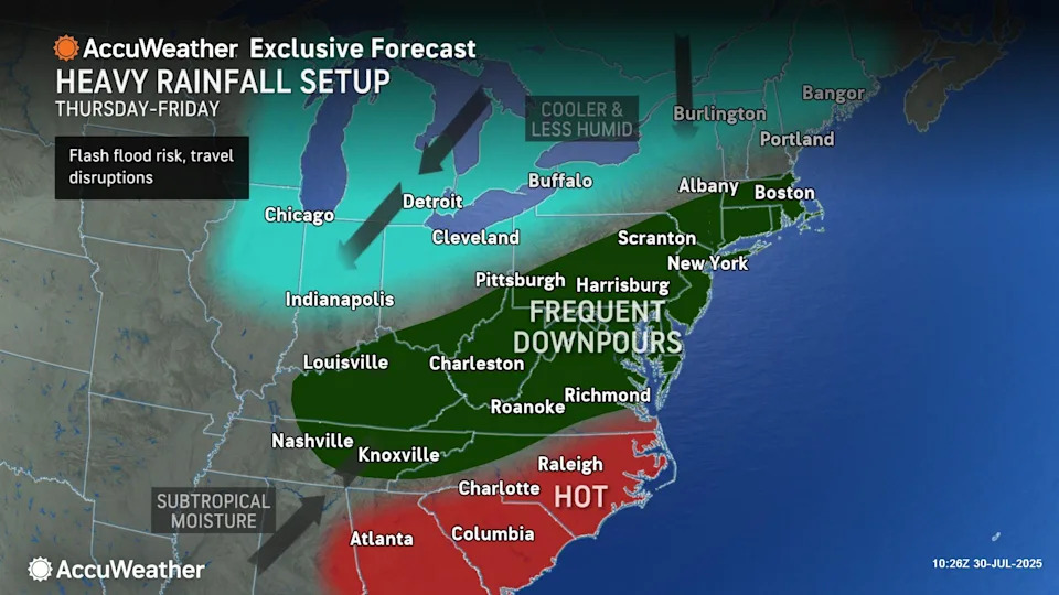
"A flash flood risk will exist along a significant portion of the mid-Atlantic region to southern New England into Friday as the front and jet stream dip begin to join together," a release from AccuWeather added. "This joint effort will unleash a swath of heavy rain."
An AccuWeather graphic indicates that Massachusetts, Rhode Island and Connecticut are in a region labeled, "frequent downpours" from Thursday into Friday.
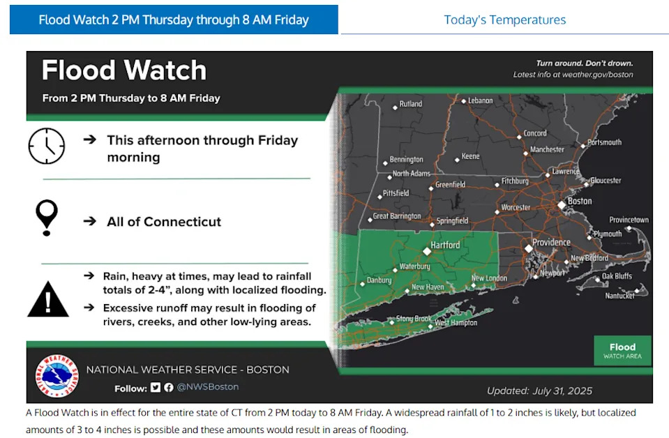
The report added that parts of Connecticut could get up to four inches of rain when all is said and done.
And that's why flash floods could become an issue, according to experts.
“Heavy rainfall can lead to flash flooding in a matter of minutes, especially in areas with hilly terrain, creeks, streams and other flood-prone spots," AccuWeather Chief Meteorologist Jonathan Porter said in a written statement. "Drivers should never attempt to go down a flooded road, even if the water appears to be only a few inches deep. It’s impossible to know how deep the water is, how fast it is moving or if the road or bridge underneath has been compromised or washed out.
"Most flash flooding fatalities involve vehicles and are preventable. Do not put yourself, your passengers, bystanders and emergency responders at risk. It is important that everyone take flash flood watches and warnings seriously, especially after dark."
The rain is expected to move out of the Norwich area by 2 p.m. Friday, according to the National Weather Service.
The weather entity reported in its forecaster's discussion that, "High pressure builds in late Friday and will then remain in control through Saturday night. This will lead to clear skies by Friday night with plenty of sunshine on Saturday."
The report noted that "Friday will be an anomalously cool day for the first day of August," with high temperatures in the 60s to low 70s.
What's the weather forecast for the weekend?
There's good news when it comes to the weekend.
Saturday is predicted to be sunny, with a high near 79, and overnight lows in the high 50s. Sunday is also expected to be sunny, with a high near 83 and lows around 60.
An AccuWeather report online added that temperatures are expected to cool down into the beginning of next week, also noting the humidity won't be as bad as it has in Connecticut as of late.
This article originally appeared on The Bulletin: Heavy downpours, floods expected in CT Thursday, July 31. What to know


Comments